Three things stand out about the East Stony Creek Trail to Wilcox lake:
This is one of the best hiking routes in the southern Adirondacks
East Stony Creek is noisy and beautiful
The intense green of the Adirondack forest in mid-June
At various points during the day the black flies also got my attention, but I'll forget that part soon enough.
East Stony Creek. This location is 1.5 miles from the parking area and from this spot to the bridge the trail is within sight (or sound) of the creek the entire way. On the day I was there the creek was running high following three weeks with substantial rainfall.
Just below the hiking bridge that provides access to Wilcox Lake.
This trail was previously marked for snowmobiles but blue markers have recently been added to designate the route for hikers. In the past there were parking complications at the trail head but a new parking area solves that problem. From the parking area hikers should continue along the road for four tenths of a mile and pick up the trail at the end of the road (where parking is now prohibited). The rest of the route is unchanged and the first quarter mile crosses private land with the permission of the land owner (so stay on the trail). The old trail to Tenant Creek Falls, which also crossed private land, is now closed. A new route to Tenant Creek Falls leaves directly from the new parking area.
From the new parking area it's 4.2 miles to suspension bridge over East Stony Creek. From that point it's one more mile to Wilcox Lake but you could choose to skip that part. The creek and forest you pass through along the way are well worth the walk. After crossing the bridge the mile of trail to Wilcox Lake is heavily eroded and Wilcox Lake itself has suffered from overuse in the past. That said, it's an attractive lake and I've been there twice and not seen a soul either time.
The newly built parking area is located on Hope Falls Road .4 miles from the end of the road (and the previously used parking). The trail to Tenant Creek Falls, which previously started at the end of the road, has been re-routed and leaves directly from the new parking area. That new trail is not shown on map above. You can see the new route here on the DEC website.
Green. Deep, intense green. In June the Adirondacks are a temperate jungle.
The East Stony Creek trail is within sight of the creek for much of the way and it is an exceptionally attractive path. The forest is mature second growth composed mostly of Hemlock with hardwoods mixed in. The high canopy, and open forest floor, provide a feeling of remoteness.
Green
Wilcox Lake from the point where the trail reaches the lake. A pair of loons were hanging out in the small bay to the left of where this was taken. A side trail leads to a nice lean-to on that side of the lake. To the right a path leads to the site of a new lean-to build in 2016 to replace the one that I visited the year before. The old one had stood for several years on the verge of collapse.
Dishrag Pond appears on modern maps as a tiny blue dot deep in the heart of the Blue Ridge Wilderness. The pond made its' first appearance on USGS topographic maps in the 1950s and that curious name has been on the list of Adirondack ponds ever since. The Blue Ridge Wilderness Master Plan (1) contains a single paragraph which describes the pond as extremely remote, devoid of fish, and exceptionally shallow. Historical images from Google Earth show a small body of water at the location but images from August 2015 show a mud flat surrounded by a swampy perimeter. A perfect destination for a hike.
Screen capture from Google Earth showing the pond as it appeared in August 2015. The Blue Ridge Wilderness Master Plan notes that the pond is exceptionally shallow with an average depth of one foot. From that it's reasonable to guess that the 'pond' goes missing when conditions are dry.
My plan was to walk the Northville Lake Placid Trail (NLPT) north from Wakely Pond (2) to intersect with a unmarked path that runs up the valley toward Dishrag pond (3). That path follows the route of a long abandoned woods road that ran from the Cedar River Road to the headwaters of Brown's Brook. It's just under five miles on the NLPT to the intersection and an additional 2.5 miles up the drainage to the vicinity of Dishrag Pond. All was going according to plan until I reached the crossing of Brown's Brook where the bridge is partially out.
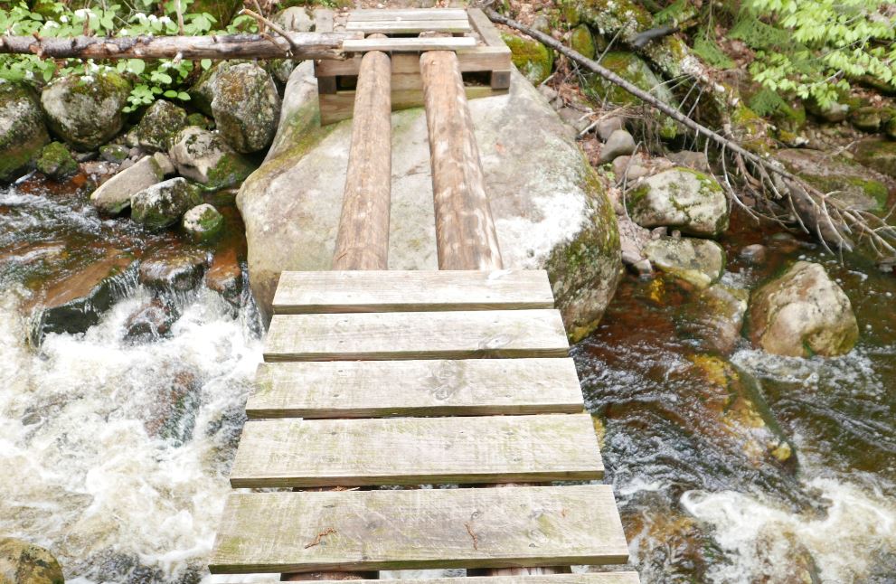
The NLPT bridge crossing Brown's Brook is missing half its' planking. It's not evident how it got into this state since it's a relatively new bridge; this section of trail was opened in just the last ten years. When the water is low you can rock hop to cross the brook and, if the logs are dry, you might chose to walk across the beams. On this day the logs were damp and slippery and I was not prepared to wade. So I headed up stream to find a place where I could get across with dry feet. On the way back I crossed the broken section of the bridge on my hands and knees using my hiking pole as a brace. It was not graceful but at that point I was not looking for style points.
Normally you might bypass the bridge and rock hop to cross the stream but two days of heavy rain had the brook running hard. I also considered walking the exposed logs but they were damp and slippery. Since I would be going up the valley anyway I figured the best bet would be to bushwhack along the stream until I found a place where I could cross. The first complication with that plan was that the banks of the brook are quite steep just above the bridge. So headed back up the trail to find a better spot to rejoin the brook. Eventually I did scramble down to the brook to take a look but the near bank was still quite steep and it was bordered by thick brush. Not ideal. More bushwhacking upstream expended a lot of energy but eventually I was able to get across with dry feet. My advice? Be prepared to wade this stream unless you know that the water is low.
A dense spruce thicket lines the north bank of Brown's Brook for a considerable distance above the NLPT bridge. It's a good 100 yards through this thicket before you emerge in the more open forest that lies beyond.
Getting to the far side of the brook revealed the next challenge. A spruce thicket lines the north bank of Brown's Brook and it took several minutes to find a way through and reach the open hardwood forest beyond. The spruce thicket along Brown's Brook is extensive and large spruce are present in the forest all the way to Dishrag Pond. This is notable because spruce were highly prized by loggers working this country in the early days of Adirondack logging. The abandoned road I would eventually find is seen on the first USGS map of the area published in 1903 and that probably means the area was logged before that date. The large spruce present today might have been too small to bother with back then and the passage of over 100 years has allowed them to reach mature sizes today.
The route to Dishrag Pond from the NLPT
Coming out of the band of dense growth along the brook I was unsure how far it was to the old road. Since I would be going up the valley either way I hedged my bets and set out towards a large unnamed vly that sits half way between the NLPT and Dishrag Pond. Following this course I would eventually reach the vly or find the path. After forty five minutes of bushwhacking pushed through a wall of brush I stepped out onto a clearly defined woods road. I'd hit the path at the point where the road forded the brook that flows out of the vly. The path, the brook and the vly came into view at the same time as did clarity as to where I was. A few minutes earlier I had thought that I'd have to give up on Dishrag Pond because of a lack of time, but this changed everything. The way was now clear. I could follow the old road to see where it goes.
The old road just above where it fords the brook flowing from the unnamed vly. Until I stepped out on to it I was not sure how distinct the way would be. This would be hard to miss.
Looking down the vly from the western end. This point is easily reached from the abandoned road that passes south of the vly.
From the vly to the vicinity of Dishrag pond the road is easy to follow but not easy going. Blowdown blocks the way in numerous places and the surface was consistently wet and muddy. Even so, I made decent time and just as I was starting to think that I must be getting close I rounded a bend to see the rusted hulk of a long abandoned car. The Ford coupe (I think from around 1940) had probably broken down at that spot and it has remained there ever since.
This abandoned car at the end of the old woods road provides known location for orienting yourself for the final push through the forest to Dishrag Pond. It appears to be a 1940 Ford Coupe and it probably broke down at this spot and was abandoned.
Just past the car the road ends. The 1903 USGS map shows the road reaching a small water body. If that was correct then the final stretch of road has been completely reclaimed by the forest. I couldn't tell exactly where the pond lay in relation to where I was, but, having come so far, I took my best guess and headed off through the forest one more time. What I learned is that the quarter mile between the end of the road and the string of beaver meadows below Dishrag pond is wet, very rough, and extremely thick. I hoping for at least a glimpse of Dishrag Pond but it was not to be. The pond couldn't have been more than a few hundred yards away, but it was 2:00 pm and getting there was going to take a while. So I turned for home. I'm unusually pretty good at retracing my steps through the woods and I tried to return to the spot where I had left the road. But even that proved to be difficult. As I said, the terrain is rough and the cover is exceptionally thick.
Looking across one of the beaver swamp/meadows just downstream from Dishrag Pond. The Blue Ridge is seen in the background.
If you want to reach Dishrag Pond leave the road 300 yards back from the place where you find the old car. Head north north west and stay in the hardwoods for as long as you can. I may have to return some day to see what Dishrag Pond actually looks like.
(1) Blue Ridge Wilderness Master Plan
(2) There is limited parking for the NLPT north at a pull-out on the Cedar River Road at Wakely Pond, The NLPT leaves the road at that point and enters the woods on a gravel road that can be driven a short distance to a pull out where additional cars can be parked.
(3) Current maps so the route as an unmarked path that ends at the vly halfway to Dishrag Pond. In fact it's an old woods road easily followed to a point a quarter mile from the pond.
The many projects I work on move forward in fits and starts but, over time, they do move forward (recall my approach to hiking: Start Slow, Keep Going). Case in point, The Moreau Lake State Park GIS that I've previously mentioned has progressed to the point where I have useful data to share.
I have created four map layers that hikers can use to plan outings at Moreau Lake State Park (MLSP). These layers include recent additions to the park including new trails in the Lake Bonita section. The trails map is current as of May 2017. The layers can be viewed in Google Maps (seen above) or you can download the files and open them in Google Earth. The four layers are:
The files available for download are in the KML format. KML files can be opened in Google Earth or they can be imported into QGIS or other geographic data management software for use in a geographic information system. Perhaps the most useful layer shared here is the trail map layer. Nearly all of the data on which the trails layer is based was obtained by walking the trails and capturing GPS tracks along the way. Same for the trail junctions layer. The junction positions are based on GPS waypoints. The boundary layer was digitized from existing maps made available on-line by the Office of Parks and Recreation and Moreau Lake State Park and refined using maps from additional sources such as the United States Geologic Survey. Please keep in mind that while I believe the average accuracy of the trail maps to be on the order of 15 to 30 feet, trails are sometimes rerouted and there is always the potential for errors. Pay attention to trail signs and know where you are going. Signs indicating private property should always be respected and the boundaries represented in the boundary layer should be considered to be approximate.
Most trails in the park are well marked and many junctions have signs that assign a number to that particular junction. The junctions layer represents the named junctions using "S" followed by a number (that's how they are shown on signs and park maps). Some junctions are not marked and those are numbered using "U" followed by a number. Similarly, most trails in the park have official names. Some newer trails and short connecting trails are unnamed and these are referred to as "unnamed trails". In a few cases I've provided descriptive names such as the "Lake Bonita Loop."
Screen capture of the Moreau Lake State Park GIS in QGIS. The boundary (green line) and trails (colored lines) are layered on top of a base map that uses natural color images downloaded from the New York State Ortho Imagery web site. The aerial images are downloaded in tiles (with 25 or so tiles visible above) and I didn't include images for areas outside of the park. That's why the areas around the edges show map features against the white background. You can get a sense of how the layers are managed by looking at layers panel on the left side. Each item in the list represents a layer seen in the map. Only the checked layers are displayed. This map shows trail and boundary layers along with a wetlands layer (wetlands and bodies of water shown in blue). The power of GIS lies in this ability to view and analyze different types of information with a shared geographic context.
The same map but this time infrared imagery was used for the background. (2001 infrared imagery downloaded from the New York State Ortho Imagery web site). Infrared images show foliage as red and the deeper reds represent denser foliage. These images were made in early spring when leaves are not present most deciduous trees so the deeper red areas allow us to see where conifer (evergreen) trees are present. Most conifers in Moreau Lake Start Park are Hemlock trees
While I'm presenting the boundary and trails layer here, maps for hikers is not my actual goal for the MLSP GIS. The goal is to support the study of the ecological systems found in the park. More on that in future posts.
In a previous post discussing new trails at Moreau Lake State Park I mentioned the idea of hiking a route I referred to as the "grand tour". With the new trails around Lake Bonita I figured it would be possible to walk a big loop that would cover around 15 miles. That was a pretty good estimate. I walked the route last weekend and it went for 14.3 miles with over 3000 feet of cumulative elevation gain.
The route captured using GPS. The red line is the Moreau State Park boundary and the blue line represents the route. Lake Bonita is seen at the lower left and the trailhead is at the upper right (where the blue lines of the route converge). I parked on Spier Falls Road at the informal trailhead at Mud Pond. The yellow line covers four miles. That's the distance as the crow files from the starting point to Lake Bonita. The Google Earth elevation profile help to explain why I was so tired at the end of the day. The low point is at 400 feet and the high point at just over 1200. It's the ups and downs in between that get you. Note to self for the next time I want to try this. It's NOT an easy walk.
There's nothing special about this route and, at one time or another, I've previously walked every inch of these trails. But, like many hikers, I prefer routes that loop so a long looping route with lots of interesting scenery and a 20 minute drive to the trailhead just had to be done. I also figured it would be a good shakedown for tougher trips I might try later in the season.
It's easy to underestimate the trails at Moreau Lake State Park and the "grand tour" turned out to be kinda grueling. Somehow I had forgetten about the relentless ups and downs that characterize the trails and I hadn't planned for the bursts of rain that punctuated the day. The rain made the trails a little slick which meant that a tiny bit of extra energy was needed for every step. You might imagine that I'd learn from days like this but the evidence indicates that this is unlikely.
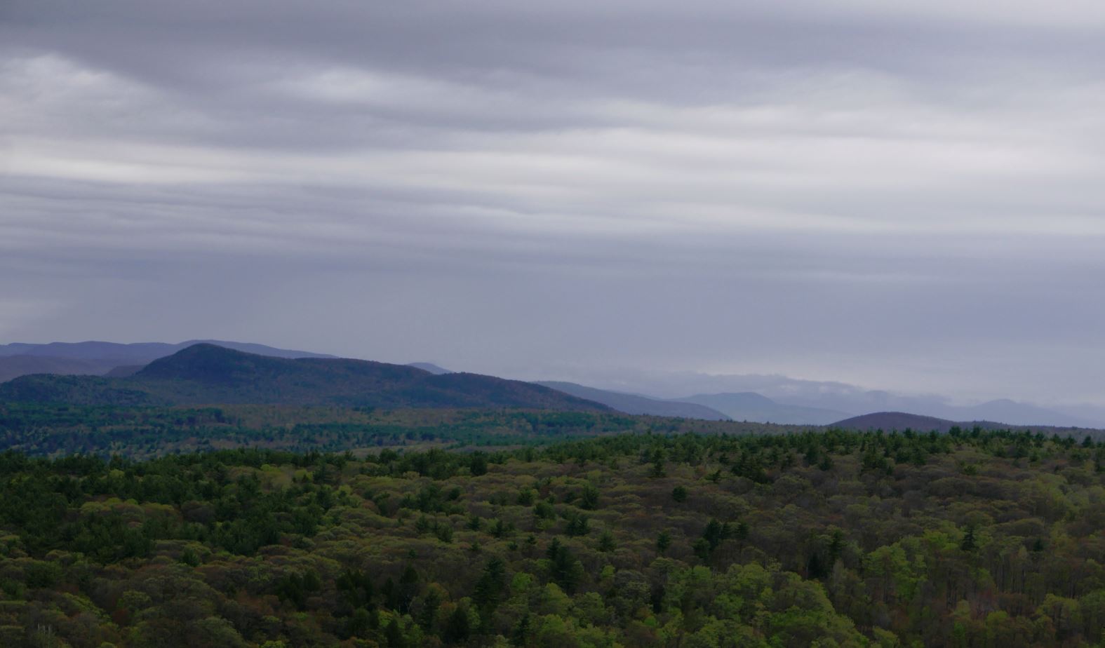
Looking east from the Moreau Lake Overlook. Southern Green Mountains just visible in the distance. I've taken similar shots from this spot many times but this is one of my favorites. A brief downpour rolled through shortly after I shot this picture.
But this is not complaining. I'd go again tomorrow if I could get away. My legs complained. My feet complained. And the next morning pretty much all of me complained. But I got exactly what I wanted. A seven plus hour walk through the varied and always interesting forests of MLSP. It was a grand tour.
The other side of the ridge, looking west towards the Adirondack foothills. The water in the foreground is the reservoir backed up by the Spier Falls dam on the Hudson. The Turkey Vulture is a bonus.
I couldn't decide which of these shots I liked better. The one with the closer view of the Turkey Vulture or the one with more background. So you get both.
Looking northwest towards the southern Adirondacks.
A small forest fire singed a few acres last spring (2016). The larger trees survived and blueberries and other post-fire opportunists will be abundant this summer.
More of the burned area in the foreground and the Spier Falls dam behind.
Overall, the winter of 2016-2017 was mild. Storms in March and April moved the snowfall total towards the average but temperatures for the season were well above normal (1). So entering the last week of April spring was in full control of the southern Adirondacks. Over the past few years I've come to see early spring as a good hiking season with one potential drawback, mud. During the winter months moisture in the soil freezes and it takes a while when spring arrives for this frozen layer to thaw. Rain and snow melt can then saturate the ground above the frozen layer and creates the muddy mire we associate with "mud season". It's not pleasant to hike through and many unpaved roads are closed until May to prevent damage. Even so, if you exercise a little judgment you can get out during mud season in most areas without damaging the trails. Plus, if your timing is good, the Adirondack Protection Force (mosquitoes, black flies, and deer flies) will waiting for warmer days to come to launch their assaults on those who venture out.
Brand new signs clarify the options at the junction of the Godfrey Road access trail and the NLPT.
My day started on the trail that leads from Godfrey Road to the Northville Lake Placid Trail (NLPT). At the trail junction just past the bridge over West Stony Creek I turned towards Woods Lake and the Benson Road. I had walked parts of this section previously. From this end on my way to Three Ponds Mountain and on a different day from the Woods Lake end turning back at Abner Brook. This left a two mile section along Abner Brook that I had not visited and still wanted to see. I planned to hike to the NLPT bridge over Abner Brook and then leave the trail and bushwhack over a ridge and into the valley of Notch Brook. A 19th century road passes up that valley and through a low pass immortalized on USGS topographic maps as "the notch". The old road would provide a route back to the NLPT and back to the car and, if time allowed, I wanted see what the "notch" looks like.
The red line is the NLPT section from Benson Road near Woods Lake (lower right) to the West Stony Creek North Branch Junction (at the sign post pictured above). The dark line is the route described in the story.
The day went mostly as planned though I didn't go as far up the ridge as I thought I might. This was my first real outing of the season and the effects of winter were weighing on me. As it was, the route covered 10 miles with bushwhacking and route finding. A pretty good stretch of the legs.
Abandoned beaver ponds transition to swampy meadows. Beaver are a keystone species in the Adirondacks shaping the landscape and supporting ecological variety.
Abner Brook just below the bridge on the NLPT. Abner Brook cuts a meandering path through a relatively flat valley creating ideal habitat for Beaver.
This was not one of those hikes where a single place stands out as the "best" part of the day. It was, however, a warm, cloudless early-spring day with dry trails and no bugs. That combination is hard to beat. But, a few things are worth noting:
The Abner Brook Valley contains an extensive network of beaver meadows, swamps and ponds. This valley is a great place to see the full range of effects this creature has on the Adirondack landscape.
A cluster of large, healthy-looking, Beech trees on the Wallface Mountain ridge
A ravine with interesting talus slopes and a possible micro-climate
The tranquil beauty of the upper Notch Brook Valley
A bit of snow remained at the bottom of the small ravine I explored while crossing the Wallface ridge. The steep slope on the southern side of the ravine prevents direct sun from reaching the slope. Creating an environment that will on average remain several degrees cooler than surrounding terrain.
The ravine was perhaps most interesting. One hundred feet deep at most this glacial gouge is barely detectable on large scale topographic maps but quite striking as seen from the rim. The ravine crosses the ridge with an east-west orientation and the south-side bank is steep with a small cliff band at the top. Over the millennia since the last glaciation rocks and small boulders have fallen from the cliff band and created a talus slope. The orientation of the ravine means that even in high summer the sun will not reach the bottom until afternoon and further up the slope there are areas that probably never see direct sunlight. Winter comes early and spring arrives late in this micro-valley. And the talus that makes it rough going for hikers also limits the advance of soil and trees. magnifying the micro-climate effect. This is the kind of place where a botanist might look for uncommon plants.
Notch Brook. Late afternoon. April 24th, 2017. A perfect place for a short nap.
The Benson to Wells road crossed Notch Brook at this point and the abandoned road is easily distinguishable on the far side. Below this crossing (towards Benson) the road is still easy to follow though extensive blowdown results in many detours. Above the crossing the blowdown is even heavier and in places the old route becomes indistinct. I still didn't make it to the height of land in the "notch". Maybe next time.
The Adirondack wilderness is wild but it is not untracked. A cook stove near the abandoned Benson-Wells Road.
Tree barnacles. Some kind of fungus seen on a downed tree at 1800 feet. Over a small area all the downed trees were covered with this growth. It may be common but I don't recall having seen it elsewhere. Maybe I just haven't noticed.
Notes
1) Heating Degree Days for Glens Falls New York. In 2017 March was slightly colder than average but January and February were well below the 10 year average.
It was just 24 months ago that 750 acres formerly held by the now closed Mt. McGregor Correctional Facility were formally added to Moreau Lake State Park. Since then a new parking area for hikers and three new trails have been built. That's a pretty good pace for these sorts of things but what makes this a truly impressive effort is that these new trails are really well thought out. Moreau Lake State Park now offers hikes ranging from a couple of miles to a "grand loop" covering nearly 15 miles without any retracing of steps (you can bet an account of that walk will appear on this blog in the future). My most recent outing, covering nine miles, took me past two attractive lakes, over ledges and past cascades and through an attractive and varied forests. There are good view along the way of the Hudson River and the southern Adirondacks.
An overview of the Moreau Lake State Park trail system. The heavy blue line, starting at the bottom left, is the route described in this post. The other colored lines seen on the map represent other trails in the park. For scale, the route represented by the heavy blue line covers a distance of just over nine miles. The two sections closest to the bottom of the image are new trails added as part of the Lake Bonita expansion.
The newest trail leaves the Lake Bonita Loop Trail near the spillway at the north end of the lake. From there it's about 1.5 miles to a to a junction with the West Ridge Trail. At the time of this writing that junction is unmarked but the trail itself is well marked (parking is on the Corinth-Wilton Mountain Road).
The Western Ridge Trail is one of the primary access trails that lead up onto the Palmertown ridge and the Park's main trail system. The Palmertown Ridge is interesting from both geological and ecological perspectives and evidence of the last glacial period lies heavily on this landscape. It is generally believed that the ice sheets of that last glacial period retreated from this area between twelve and fifteen thousand years ago with mountain glaciers persisting into the more recent end of that range. That's a long time by human standards but not even the blink of an eye in terms of geologic time. Walking the trails on the Palmertown ridge always reminds me of this. There are many places where soil lies just a few inches thick on top of deeply scarred bedrock.
A rock outcropping along the new trail from Lake Bonita to the Western Ridge Trail.
The geology of the Palmertown ridge strikes me as being somehow different from similar landscapes in the southern Adirondacks. For example, the ridge crossed in the first couple miles of the Northville to Benson section of the Northville-Lake Placid Trail has some characteristics in common with the Palmertown Ridge. The Northville ridge is a little higher but ecologically similar; an Oak-Hemlock forest. But the landscape has a different feel. Could it be the distinction between being part of the Canadian Shield (the primary geologic formation of the Adirondacks) as opposed to rock that has been pressed up against the shield. I'm imagining that as a possibility for the Palmertown Ridge. The most likely explanation is that this is my imagination run wild. Perhaps someone with more knowledge of the geology of the region will let me know.
In any case, the terrain encountered on the Palmertown ridge is unexpectedly rugged and, according to my GPS, the total elevation gain for the route I walked was 2200 feet. There's just a single significant climb so nearly all of that elevation gain comes from the relentless ups and downs you encounter along the way.
The shore line of Lake Anne. This small, shallow, lake is ringed by an ecologically interesting marshy shoreline.
One point of specific interest for me was a stand of spruce on the northwest shore of Lake Bonita. I had noticed the trees on my previous visit. But that was a day of our only major snow fall of the year and with darkness approaching I took no time to investigate. Still, I did notice two things:
The trees were some kind of Spruce (I was not sure of what variety)
The trees looked out of place
Taking a closer look under benign conditions confirmed both points. My first impression had been that this was a stand of Norway Spruce; a widely planted import to the Adirondacks. When Norway Spruce grow in the open --as the do in various places in Saratoga Spa State Park-- they exhibit a distinctive branching pattern that makes them especially easy to identify. However, when growing close together under constrained conditions Norway Spruce can look a lot like other Spruce varieties that are native to this region. However, there is one identifying characteristic that trumps all others. Norway Spruce have long cones that are much larger than any other spruce from around these parts. These trees are Norway Spruce.
A lovely cascade crossed by the new trail section that runs from Lake Bonita to the Western Ridge Trail.
From the first overlook on the Western Ridge Trail. This popular destination is barely a mile from the parking area on Spier Falls Road. It's a bit more than 2.5 miles from the new parking area on Corinth Wilton Mountain Road. The view is of the Spier Falls reservoir on the Hudson River and the Southern Adirondacks beyond.
Lake Anne. Late Winter.
This open glade on the ridge line near the Western Ridge trail was probably open meadow just a few decades ago. The trees are Chestnut Oak. A common species on this section of the Palmertown ridge. This species somehow favors the edges of steep ridges. I'd love to more about the history of the forest on this ridge.
I have not been posting much recently because I have not been able to get out but on successive January weekends I got away for quick jaunts to visit a couple of favorite haunts. The first outing was to Moreau Lake State Park on a day when over a foot of snow fell. Over the six hours I was on the trail eight to ten inches of snow fell and by late afternoon tracks I had made in fresh snow in the morning had vanished.
Looking out from the lean-to at Lake Anne. For a time the snow was falling at a rate that accumulates several inches per hour. You might think that the video has been speed up in some way. It has not.
The route. Note the red line leaving Lake Bonita. There looks to be a new marked trail going off in that direction. Also, my route does not follow the actual trail in several places. I tend to wander around investigating areas that catch my eye. The marked trail is easy to follow.
It appears that the new parking area on Corinth Mountain Road will be kept plowed and open in the winter and that provides convenient access to new trails in the southern part of Moreau Lake State Park. I followed one those new trails to Lake Anne. From there a previously existing trail joins up with the Park's main trail system at junction S9 (if you are using the Park's official trail map).
The trail to Lake Anne (opened in the summer of 2016) passes through lands added to the park following the closing of the Mount MacGregor Correctional Facility. Intriguingly, on my way back to the car I followed the loop trail around Lake Bonita and it looks like another new trail has been added leaving the northern end of Lake Bonita next the spillway. If it goes where I think it might go it could make for a nice loop hike connecting with other trails that can be reached from Spier Falls Road. I'm planning to get back soon to take a look.
A Hemlock glade in winter. Snow fell heavily throughout the day.
Lake Bonita from near the trail that circles the lake. This is from the southern end of the lake looking north.
Lake Bonita again. This time from the far shore looking roughly from the east to the west.
Northville-Lake Placid Trail to the NLPT High Point
My second outing was on the Northville-Lake Placid Trail south from the Rte. 28n junction just east of Long Lake village. This trail head is less than a mile from a family home in Long Lake and I've walked this route many times. However, this outing was different. A series of storms over the previous two weeks had dropped three feet of snow which was then softened up by two days of unusual warmth (60+ in Long Lake in February? That can't be right). Higher up the snow was even deeper; three to five feet depending on the slope and the drifts.
Video from near the place where I turned back. I didn't actually make it to the highest point on the ridge turning back a quarter mile or so short of the height of land. I had passed my turn back time and the going in very deep, soft, snow was sloooow to say the least So following a quick lunch I headed back down.
The trail was partially broken to the point where the Three Brooks Ski trail joins the NLPT but past that junction no one had left a mark in the deep snow. Breaking trail while climbing makes for slow going and it took me 4 hours to cover four miles. Coming back down was a lot faster although fatigue started to counter the benefit of having a broken trail to follow. Seven hours on show shoes in deep snow is a full day. I was using a pair of lightweight snowshoes that were not very well suited to the conditions. This was one time when my larger Sherpa snow shoes would have been a better choice.
Starting out the day was bright and sunny. The Black Spruce Bog near the trail head is a consistent source of good photos and, for those interested in Adirondack ecosystems, one of the easiest places in the park to see this type of bog. Larger bogs are found to the north and west but this is one of the southernmost instances of this type.
Near the place where the NLPT crosses Sandy Creek about a mile from the trail head.
Sandy Creek. This photo was taken the day before the hike on a short reconnaissance walk to judge conditions I would find the following day.
The Long Lake Spruce bog in early morning.
GPS Accuracy: This is what I've been talking About
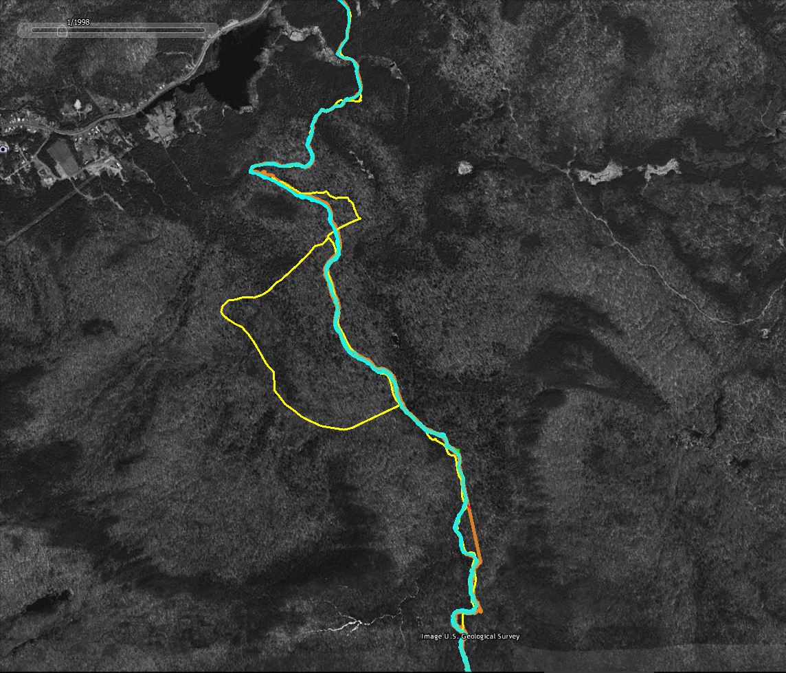
I've written about GPS accuracy in the past but nothing beats an example. The screen captures that follow (from Google Earth using historic imagery as the basemap) show how "accuracy" varies when using common GPS devices in the woods.
Legend:
Yellow Line: The trail as represented in the downloadable DEC Hiking Trails file. I don't know how DEC created the trails file but in many areas it shows only an approximation of route the trails actually take.
Cyan Line: The track captured by my Garmin GPSMap64 GPS Receiver. This was an out and back hike, so the two lines represent the trip up the mountain and return trip back down. Because I was snow shoeing in deep snow the two tracks should, in theory, overlap. I stayed in the trail I broke on the way up on the return trip.
Orange Line: The track captured using the GPS app on my phone. The two lines show the out and back routes as described above.
The Red Line is a high accuracy representation of the route. You can't see it in these images but the trail in the area shown follows an old woods road and it is possible to make out the route in the Google Earth imagery. The red line was traced from the image and should closely follow the actual route on the ground.
The horizontal green line; For scale, the green line represents a distance of 60 feet on the ground.
A section of the route overlaid with two sets of GPS tracks (the out and back tracks from two separate devices). The yellow line is less accurate representation from the DEC Trails download. The red line closely follows the actual route as traced from the image.
Same as above with the less accurate tracks captured using the phone GPS hidden. The blue lines --tracks captured by a good consumer grade GPS unit-- vary by an average of 20 feet. The absolute variance from the traced representation of the trail (the red line) is also on average in 15-30 foot range. Larger variations might be the result of wandering off the trail at certain points.
For context, more of the followed route. The yellow "bulge" in the middle is a side trail off of the NLPT main route. The straight orange towards the bottom of the image is where the phone based GPS lost the GPS signal for a period of time. The straight line connects the points where the phone lost and later regained the signal.