Sometimes things come together in unexpected ways and you just have to savor the moment. It was four PM and I had hiked to County Line Lake from the trailhead on Pinnacle Road (southwest of Benson NY). I'd scrambled part way up the small unnamed mountain north of the lake and now I was just a mile from the trailhead at the crossing of the northeast branch of Pinnacle Creek. Pausing, I was struck by what a perfect day it was. March 26th on the calendar but not the day I had expected. Temperature in the upper 40s. A brilliant blue cloudless sky. Not an annoying insect of any kind to be seen. And the transition from winter to spring nearly complete.
Route to County Line Lake from Pinnacle Road. The side trip to the right was to the vly that is the primary source of the NE branch of Pinnacle Creek. Image from Google Maps
Ten hour earlier I had been drinking coffee and scanning a map of the southern Adirondacks looking for a place to get out for a hike. I always have a few options tucked away in the back of my mind but I was looking for someplace completely new. One of the things I love about the Adirondacks is that there are so many unique and interesting places to explore. And there it was; County Line Lake.
A small cascade on the slope of Pigeon Mountain.
As beautiful as the day was it's still March in the Adirondacks. The overnight temperature at 2500 feet had certainly dipped into the 20s. The light spray from a small cascade encased these leaves in ice.
Beaver shape the Adirondack landscape. Pinnacle creek flows through a valley where Beaver create small ponds in an endless cycle of use and reuse.
Most years on March 26th this area would still be firmly held in Winter's grasp with plenty of snow and ice. But the winter of 2015-2016 has not been most years. This winter is now in the books as one of the mildest since records have been kept here abouts. A few lonely patches of ice remain in sheltered places above 2000 feet, but very minimal. And, most remarkable of all, even the dreaded "mud season" has nearly past. In a typical winter the first couple feet of soil freezes solid. In the spring, after the snow melts, that frozen soil transitions first into a soupy mud; mud season. But not this year, for the most part this route has already dried out.
County Line Lake. March 26th, 2016. The lake sits at 2500 feet and, it was still iced over. But probably not for long. The ice was out on all the water lower down.
The namesake of this route, County Line Lake is pictured above. It's a decent sized body of water but I couldn't get a sense of the depth and it might be shallow. Bill Ingersoll notes in his Discover the Southern Adirondacks that the lake has been devoid of fish for many years. And that fits. The trail arrives at the southeast corner of the lake and basically just ends. The herd paths you typically find around a body of water that attracts fishermen and campers are not present. I crossed the inlet stream and fought through a quarter mile of brush along the north shore of the lake. From there I went up the slope of the unnamed mountain that borders the lake on the north. I wasn't looking to get to the top. I just wanted to avoid a return trip through the tangle closer to the shore. This strategy was only partly successful. The entire slope is brushy with almost no canopy sized trees.
At 2600 feet on the unnamed mountain north of County Line Lake. A snarled mess of stunted Beech saplings dominate this slope.
The forest on this slope is odd. I saw no signs of a blowdown event or fire or logging. But there are almost no large trees. The stunted trees visible in the photograph (above) are mostly American Beech and it may be that Beech Bark Disease has disrupted the normal cycle of forest succession. American Beech is a pioneer species and when the forest canopy is disturbed Beech quickly fill in. However, under some circumstances, Beech Bark Disease can kill the Beech trees before they get large enough to shade the soil so that moister loving species can get going. This can set up a cycle where Beeches fill in, die off, and fill in again. This creates a tangle of stunted Beeches that I have seen referred to as a "beech hell". Of course, that may not be what is going on at this location. The soil on this slope looked to be thin and the southwestern exposure had already left the slope bone dry. Interestingly, the few larger tree that are present (not tall but judging by the bark old) looked to be Black Cherry. Not sure what to make of that. I'd appreciate knowing the fire/logging history of this area to get a better sense of what might have led to the current state.
A beaver meadow on the inlet to County Line Lake. A short distance from the lake.
Along the inlet stream.
On my return trip I paid closer attention to the forest and it struck me that the lake is not the main attraction of this route (I might see that differently on a hot July day). The trail passes through stretches of attractive middle-aged forest with some large trees ( diameter > 30 inches) present. But it's the variety, the interesting terrain, and the streams that make this route the gem that it is.
Returning to where this tale began, sitting on the bank of Pinnacle Creek with the late afternoon light filtering through the trees, I was struck by the beauty of the spot. The first mile and a half of the route passes through a magnificent Hemlock forest; open, cool and inviting. Resting for a minute I didn't want the day to end. And hey, with three hours of daylight left why not follow the stream to it's source? Within 30 minutes I had reached the swampy vly that is the source of this brook. When the beaver have raised the water level this is probably a nice spot. But on this day the water level was low and the pond was surrounded by a mud flat. Not that it mattered. The 1/2 mile walk along the stream is as good as it gets. Through a deep hemlock forest along a brook with numerous cascades. After resting for a few minutes it was time to head for home.
Mallards on the shallow pond (vly) that is the source of the northeast tributary of Pinnacle Creek.
Hikers planning to walk the Northville Lake Placid Trail (NLTP) from south to north have long faced a bit of dilemma in deciding where to start. From the official trailhead in the village of Northville the first twelve miles of the route were along paved roads and you would have walked 14 miles, at a minimum, to reach a place where you could camp. For that reason, many thru hikers started their journey at the so called "Upper Benson" trailhead on Godfrey road.
Two new sections of trail change that calculation completely. A thru hiker might still chose to start at Godfrey road but, if you do, you'll miss two compelling new segments of the trail. The first section runs from Collins Gifford Valley Road near Northville to the Benson Road; covering a distance of 8.6 miles. The second section links the Benson Road crossing with the original route at the place where the original route crossed the West Stony Creek North Branch (the bridge about 2 miles from Godfrey Road parking area). This second section covers seven miles and both sections together add 15 miles of new trail to the the NLTP.
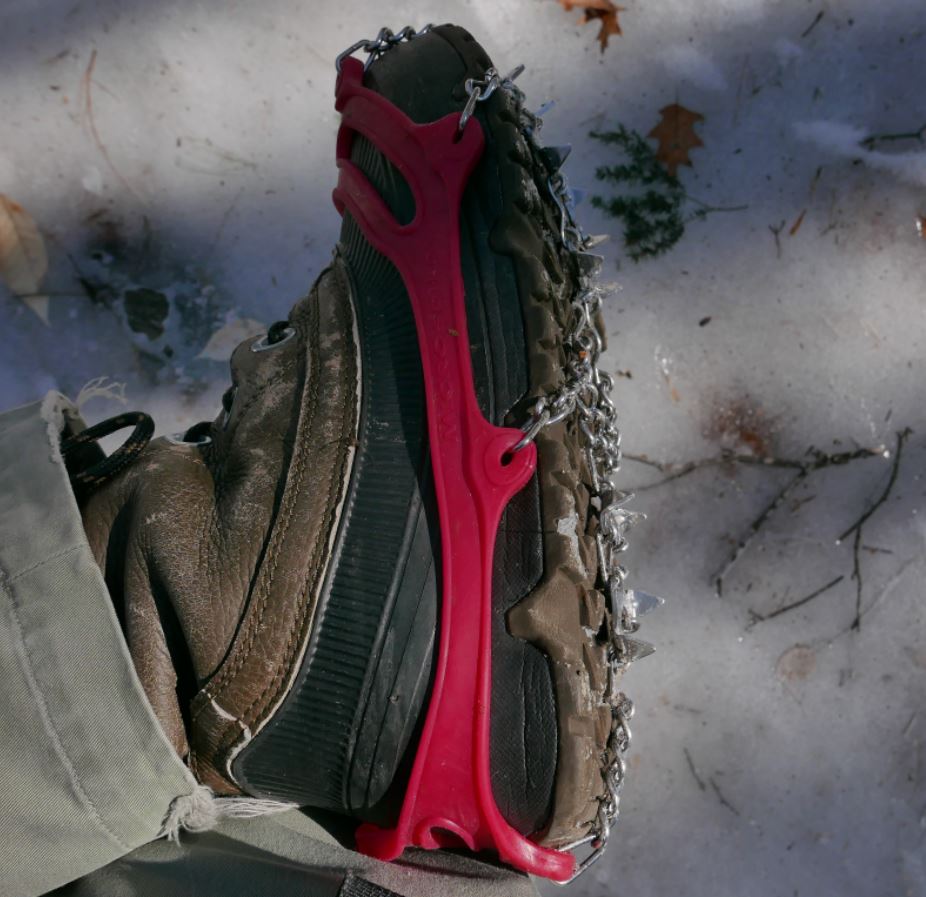
I recently walked significant portions of both of the new sections on successive weekends at the end of February and beginning of March 2016. Both trips, were made possible by the use of micro-spike "boot chains". In both cases the trails were extremely icy and neither excursion would have been possible without the micro-spikes (Images 1 and 2).
Image One
Image Two: Unusually icy conditions prevail in early spring 2016. Walking these trails would not have been practical without the use of micro-spikes.
The first of these two outings covered a portion of the the new trail that runs from the Benson Road to West Stony Creek North Branch (north of the Benson Road). The following weekend I walked the section starting at the brand new trailhead on Collins-Gifford Valley Road to the crossing of the West Stony Creek. Both hikes covered about ten miles for the round trip.
Notices at the trail registers warn that though a bridge is planned, currently there is no bridge over West Stony Creek. This is important for anyone planning to start a NLTP journey at the Gifford Valley trailhead because West Stony Creek is a significant stream. The creek can easily be forded at times of low water, but in the spring, or after heavy rains, it could present an impassable barrier.
Image Three: The only other hiker I saw on two full days of hiking is seen above on the far side of Stony Creek. He evidently hiked from the Benson road south to the creek crossing.
Not surprisingly, on the day I was there, March 6, 2016, fording the stream would have been a risky undertaking. West Stony Creek at the place where the trail crosses is wide and in early spring it carries a significant volume of water. The creek does look to be shallow, probably no more than knee deep, but with lots of ice and freezing water to contend with I can't imagine a casual hiker trying to cross at this time of year. The crossing will look completely different in six weeks and by mid-summer it might be possible cross without getting your feet wet. But without a bridge you need to factor the creek into any plan to pass thru this section. I shot a couple of short videos to illustrate.
I'm going to come back to these two outings in future posts, but for now I'll let a quick summary and some photos do the talking. Setting aside the value that these re-routes provide by finishing the long story of the NLTP, the first section, from the Collins Gifford Valley Road to the West Stony Creek crossing is a great new hiking route all on its' own. After climbing steadily for the first mile this section of trail enters a rapidly maturing oak forest that is notably different from forests along most of the NLTP. Then, at just under two miles you reach Mud Pond. The setting for the pond is attractive and open rock is visible on the ridge line northeast of the pond. The ridge appears to be easy to reach and probably has some nice views. I'm planning to return at some point to see for myself.
Image Four: Mud Pond in late winter splendor.
Past the pond the trail passes through a complex of small ridges coming down from the surrounding mountains and it crosses two stream carved valleys. Along the way the forest transitions to a more typical mix of Hemlock and northern hardwoods. This is a very attractive section of trail and the second major stream crossing, about a mile from Stony Creek, is at the head of a small gorge that also looks to be well worth a visit with time to explore.
Image Five: Details seen along the trail.
At just under five miles the trail reaches the ford of West Stony Creek. The area of the crossing, on the south side of the creek, looks to have a number of attractive potential camping spots and I suspect that this will become a well used destination.
All in all, the five mile stretch south of Stony Creek is a lovely hike on its' own terms and I have no doubt that I will return soon. When it is possible to cross it's 2.8 miles from the north bank of the creek to the Benson Road. Walking that section of trail is near the top of my list of possible future outings.
The second of my two recent hikes started at the Benson Road and covered the first five miles of the seven mile route to where the new trail joins the prior route of the NLTP. That outing was similar to the one I've just described with very ice trail conditions defining the day. The highlights of this section include the passage of Woods Lake; a long-time favorite local destination. Along the mile long shore of the lake the trail traverses some splendidly rugged terrain in crossing a ridge of Little Cat Head mountain. Little Cat Head reaches barely 2000 feet in elevation but it's an intriguing mountain with potential viewpoints. From the ridge to the point where I turned around the trail passes through mostly young second growth forests with sections of more mature Hemlocks along a couple of small ridges. I suspect that the section from where I turned back to the place where the new trail joins the old route is more interesting, but I had to leave that for another day. The Ten mile round trip --crunching along over icy ground the whole way-- is my limit for this time of year.
Image Six: Glare ice along the shore of Woods Lake. Heavy rains in the prior week followed by a temperature plunge to near zero created hard ice conditions.