Dishrag Pond appears on modern maps as a tiny blue dot deep in the heart of the Blue Ridge Wilderness. The pond made its' first appearance on USGS topographic maps in the 1950s and that curious name has been on the list of Adirondack ponds ever since. The Blue Ridge Wilderness Master Plan (1) contains a single paragraph which describes the pond as extremely remote, devoid of fish, and exceptionally shallow. Historical images from Google Earth show a small body of water at the location but images from August 2015 show a mud flat surrounded by a swampy perimeter. A perfect destination for a hike.
Screen capture from Google Earth showing the pond as it appeared in August 2015. The Blue Ridge Wilderness Master Plan notes that the pond is exceptionally shallow with an average depth of one foot. From that it's reasonable to guess that the 'pond' goes missing when conditions are dry.
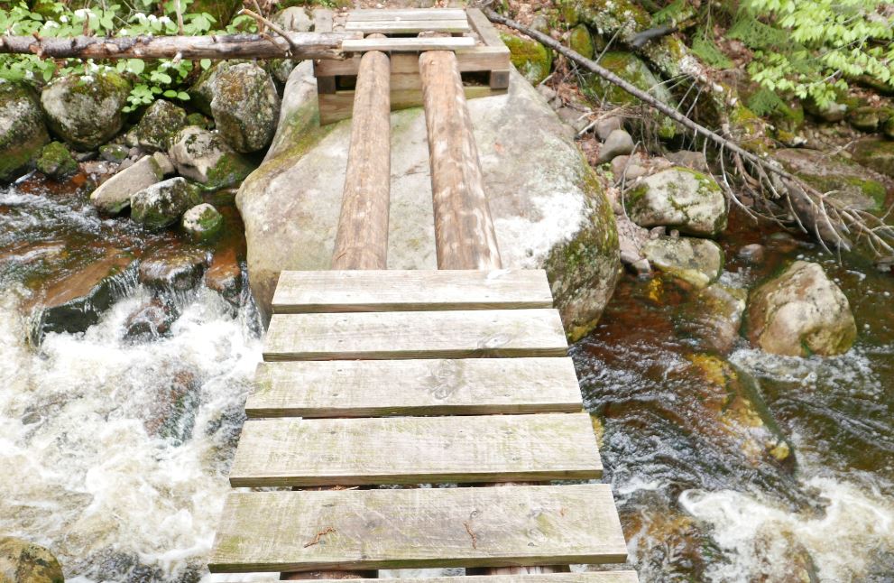
My plan was to walk the Northville Lake Placid Trail (NLPT) north from Wakely Pond (2) to intersect with a unmarked path that runs up the valley toward Dishrag pond (3). That path follows the route of a long abandoned woods road that ran from the Cedar River Road to the headwaters of Brown's Brook. It's just under five miles on the NLPT to the intersection and an additional 2.5 miles up the drainage to the vicinity of Dishrag Pond. All was going according to plan until I reached the crossing of Brown's Brook where the bridge is partially out.
The NLPT bridge crossing Brown's Brook is missing half its' planking. It's not evident how it got into this state since it's a relatively new bridge; this section of trail was opened in just the last ten years. When the water is low you can rock hop to cross the brook and, if the logs are dry, you might chose to walk across the beams. On this day the logs were damp and slippery and I was not prepared to wade. So I headed up stream to find a place where I could get across with dry feet. On the way back I crossed the broken section of the bridge on my hands and knees using my hiking pole as a brace. It was not graceful but at that point I was not looking for style points.
Normally you might bypass the bridge and rock hop to cross the stream but two days of heavy rain had the brook running hard. I also considered walking the exposed logs but they were damp and slippery. Since I would be going up the valley anyway I figured the best bet would be to bushwhack along the stream until I found a place where I could cross. The first complication with that plan was that the banks of the brook are quite steep just above the bridge. So headed back up the trail to find a better spot to rejoin the brook. Eventually I did scramble down to the brook to take a look but the near bank was still quite steep and it was bordered by thick brush. Not ideal. More bushwhacking upstream expended a lot of energy but eventually I was able to get across with dry feet. My advice? Be prepared to wade this stream unless you know that the water is low.
A dense spruce thicket lines the north bank of Brown's Brook for a considerable distance above the NLPT bridge. It's a good 100 yards through this thicket before you emerge in the more open forest that lies beyond.
Getting to the far side of the brook revealed the next challenge. A spruce thicket lines the north bank of Brown's Brook and it took several minutes to find a way through and reach the open hardwood forest beyond. The spruce thicket along Brown's Brook is extensive and large spruce are present in the forest all the way to Dishrag Pond. This is notable because spruce were highly prized by loggers working this country in the early days of Adirondack logging. The abandoned road I would eventually find is seen on the first USGS map of the area published in 1903 and that probably means the area was logged before that date. The large spruce present today might have been too small to bother with back then and the passage of over 100 years has allowed them to reach mature sizes today.
The route to Dishrag Pond from the NLPT
Coming out of the band of dense growth along the brook I was unsure how far it was to the old road. Since I would be going up the valley either way I hedged my bets and set out towards a large unnamed vly that sits half way between the NLPT and Dishrag Pond. Following this course I would eventually reach the vly or find the path. After forty five minutes of bushwhacking pushed through a wall of brush I stepped out onto a clearly defined woods road. I'd hit the path at the point where the road forded the brook that flows out of the vly. The path, the brook and the vly came into view at the same time as did clarity as to where I was. A few minutes earlier I had thought that I'd have to give up on Dishrag Pond because of a lack of time, but this changed everything. The way was now clear. I could follow the old road to see where it goes.
The old road just above where it fords the brook flowing from the unnamed vly. Until I stepped out on to it I was not sure how distinct the way would be. This would be hard to miss.
Looking down the vly from the western end. This point is easily reached from the abandoned road that passes south of the vly.
From the vly to the vicinity of Dishrag pond the road is easy to follow but not easy going. Blowdown blocks the way in numerous places and the surface was consistently wet and muddy. Even so, I made decent time and just as I was starting to think that I must be getting close I rounded a bend to see the rusted hulk of a long abandoned car. The Ford coupe (I think from around 1940) had probably broken down at that spot and it has remained there ever since.
This abandoned car at the end of the old woods road provides known location for orienting yourself for the final push through the forest to Dishrag Pond. It appears to be a 1940 Ford Coupe and it probably broke down at this spot and was abandoned.
Just past the car the road ends. The 1903 USGS map shows the road reaching a small water body. If that was correct then the final stretch of road has been completely reclaimed by the forest. I couldn't tell exactly where the pond lay in relation to where I was, but, having come so far, I took my best guess and headed off through the forest one more time. What I learned is that the quarter mile between the end of the road and the string of beaver meadows below Dishrag pond is wet, very rough, and extremely thick. I hoping for at least a glimpse of Dishrag Pond but it was not to be. The pond couldn't have been more than a few hundred yards away, but it was 2:00 pm and getting there was going to take a while. So I turned for home. I'm unusually pretty good at retracing my steps through the woods and I tried to return to the spot where I had left the road. But even that proved to be difficult. As I said, the terrain is rough and the cover is exceptionally thick.
Looking across one of the beaver swamp/meadows just downstream from Dishrag Pond. The Blue Ridge is seen in the background.
If you want to reach Dishrag Pond leave the road 300 yards back from the place where you find the old car. Head north north west and stay in the hardwoods for as long as you can. I may have to return some day to see what Dishrag Pond actually looks like.
(1) Blue Ridge Wilderness Master Plan
(2) There is limited parking for the NLPT north at a pull-out on the Cedar River Road at Wakely Pond, The NLPT leaves the road at that point and enters the woods on a gravel road that can be driven a short distance to a pull out where additional cars can be parked.
(3) Current maps so the route as an unmarked path that ends at the vly halfway to Dishrag Pond. In fact it's an old woods road easily followed to a point a quarter mile from the pond.
Overall, the winter of 2016-2017 was mild. Storms in March and April moved the snowfall total towards the average but temperatures for the season were well above normal (1). So entering the last week of April spring was in full control of the southern Adirondacks. Over the past few years I've come to see early spring as a good hiking season with one potential drawback, mud. During the winter months moisture in the soil freezes and it takes a while when spring arrives for this frozen layer to thaw. Rain and snow melt can then saturate the ground above the frozen layer and creates the muddy mire we associate with "mud season". It's not pleasant to hike through and many unpaved roads are closed until May to prevent damage. Even so, if you exercise a little judgment you can get out during mud season in most areas without damaging the trails. Plus, if your timing is good, the Adirondack Protection Force (mosquitoes, black flies, and deer flies) will waiting for warmer days to come to launch their assaults on those who venture out.
Brand new signs clarify the options at the junction of the Godfrey Road access trail and the NLPT.
My day started on the trail that leads from Godfrey Road to the Northville Lake Placid Trail (NLPT). At the trail junction just past the bridge over West Stony Creek I turned towards Woods Lake and the Benson Road. I had walked parts of this section previously. From this end on my way to Three Ponds Mountain and on a different day from the Woods Lake end turning back at Abner Brook. This left a two mile section along Abner Brook that I had not visited and still wanted to see. I planned to hike to the NLPT bridge over Abner Brook and then leave the trail and bushwhack over a ridge and into the valley of Notch Brook. A 19th century road passes up that valley and through a low pass immortalized on USGS topographic maps as "the notch". The old road would provide a route back to the NLPT and back to the car and, if time allowed, I wanted see what the "notch" looks like.
The red line is the NLPT section from Benson Road near Woods Lake (lower right) to the West Stony Creek North Branch Junction (at the sign post pictured above). The dark line is the route described in the story.
The day went mostly as planned though I didn't go as far up the ridge as I thought I might. This was my first real outing of the season and the effects of winter were weighing on me. As it was, the route covered 10 miles with bushwhacking and route finding. A pretty good stretch of the legs.
Abandoned beaver ponds transition to swampy meadows. Beaver are a keystone species in the Adirondacks shaping the landscape and supporting ecological variety.
Abner Brook just below the bridge on the NLPT. Abner Brook cuts a meandering path through a relatively flat valley creating ideal habitat for Beaver.
This was not one of those hikes where a single place stands out as the "best" part of the day. It was, however, a warm, cloudless early-spring day with dry trails and no bugs. That combination is hard to beat. But, a few things are worth noting:
The Abner Brook Valley contains an extensive network of beaver meadows, swamps and ponds. This valley is a great place to see the full range of effects this creature has on the Adirondack landscape.
A cluster of large, healthy-looking, Beech trees on the Wallface Mountain ridge
A ravine with interesting talus slopes and a possible micro-climate
The tranquil beauty of the upper Notch Brook Valley
A bit of snow remained at the bottom of the small ravine I explored while crossing the Wallface ridge. The steep slope on the southern side of the ravine prevents direct sun from reaching the slope. Creating an environment that will on average remain several degrees cooler than surrounding terrain.
The ravine was perhaps most interesting. One hundred feet deep at most this glacial gouge is barely detectable on large scale topographic maps but quite striking as seen from the rim. The ravine crosses the ridge with an east-west orientation and the south-side bank is steep with a small cliff band at the top. Over the millennia since the last glaciation rocks and small boulders have fallen from the cliff band and created a talus slope. The orientation of the ravine means that even in high summer the sun will not reach the bottom until afternoon and further up the slope there are areas that probably never see direct sunlight. Winter comes early and spring arrives late in this micro-valley. And the talus that makes it rough going for hikers also limits the advance of soil and trees. magnifying the micro-climate effect. This is the kind of place where a botanist might look for uncommon plants.
Notch Brook. Late afternoon. April 24th, 2017. A perfect place for a short nap.
The Benson to Wells road crossed Notch Brook at this point and the abandoned road is easily distinguishable on the far side. Below this crossing (towards Benson) the road is still easy to follow though extensive blowdown results in many detours. Above the crossing the blowdown is even heavier and in places the old route becomes indistinct. I still didn't make it to the height of land in the "notch". Maybe next time.
The Adirondack wilderness is wild but it is not untracked. A cook stove near the abandoned Benson-Wells Road.
Tree barnacles. Some kind of fungus seen on a downed tree at 1800 feet. Over a small area all the downed trees were covered with this growth. It may be common but I don't recall having seen it elsewhere. Maybe I just haven't noticed.
Notes
1) Heating Degree Days for Glens Falls New York. In 2017 March was slightly colder than average but January and February were well below the 10 year average.
This was my second ramble to the vacinity of the top of Blueberry Mountain. This particular Blueberry Mountain is located just south of Kemshall Mountain; a mile from the east shore of Long Lake. I had previously bushwhacked up the mountain from a point on the Northville Lake Placid Trail about 3.5 miles north of the NLPT parking area on Tarbell Hill road. The route I took on that first trip was very steep and it passed through a dense swath of Spruce and Balsam. At the time I decided my route was ill chosen and in fact I came down the north side of the of the mountain where I stumbled on the old trail up Kempshall Mountain. Since then I've been back and followed the abandoned trail to the top of Kemshall. That route climbs to a saddle between Kempshall and Blueberry and I figured that the best route up Blueberry would be to follow the old trail to the saddle and then bushwhack to the top from there. This is indeed the easier way to go.
A low cloud cover limited views from near the summit of Blueberry Mountain.
But the main reason to hike Blueberry again was that my brother Mike was visiting from Colorado and we were looking for a good outing. Something close to town, of moderate length and hopefully with views. Blueberry normally has fantastic views and I figured it to be a 12 mile round trip with the last 1/2 mile a bushwhack up from the saddle. That seemed like the right mix so off we went.
And we did reach the top basically as planned. The bushwhacking stretch was a little harder than anticipated but 45 minutes after we left the old Kempshall trail in the saddle we came to a boulder with a small cairn on top of it. There didn't appear to be any more "up" anywhere around so we declared that point to be the summit. As for the view, the top of Blueberry is in the elevation zone where dense stands of Spruce and Balsam typically dominate. And the cover on summit of Blueberry varies between dense and very dense. However, I knew from my prior visit that open rock slabs exist on Blueberry with great views. Searching around on top we did find some rock outcropings that could have had good views. Unfortunately, as the day had progressed the thick overcast had lowered until visibilty from the top was on the order of a quarter mile. Basically we were staring off into the clouds.
Yup, still limited over on the other side of the summit area.
There it is, the view, looking southwest from one of the open areas near the summit of Blueberry Mountain. This shot is from my prior visit in July of 2014.
Still, I assured Mike that there were two large areas of open rock where good views would normally be found and that maybe we could sneak a view through the clouds from one of those areas. After half an hour of searching, beating through the thickets, I sensed that Mike was starting to doubt that these "open areas" even existed (Ok, it didn't require any great powers of perception, he readily pointed out that this was his theory). Eventually we paused for lunch at a place near where we had first reached the top.
Screen capture from Google Earth showing our route. The orange line is the GPS track. The yellow line is the trail overlay from the New York State Dept. of Environmental Conservation trails map. This version (of the overlay) still shows the trail up Kempshall Mountain. That trail is officially abandoned and while still easy to follow it is not a marked trail.
A broader perspective on our route and the summit of Blueberry mountain. Kempshall is in the background.
Returning home the GPS track told the tale. We had circled around the summit of the mountain and the two large open areas (yes, they do exist) are slightly lower down; one on the west side and one on the east. We had come close to each one but had not gone far enough down the slopes to break out into the open. Oh well, there wouldn't have been views anyway. That is the story I'm sticking with. Now I'll just have to make the pleasent walk down the lake and up Blueberry again to see those great views. It could be worse.
Along the shore of Long Lake near the point where the abandoned Kempshall Moutain trail intersects with the NLPT. The lake is very low, even for this time of year (Oct. 1). The summer has been unusually dry and hot
Long Lake from near place where the picture above was taken. The bushes in this photo are also in the previous picture. In that one seen from the side. A point was under water when this picture was taken in July of 2014.
Forest scene from along the NLPT along the way to Blueberry Mountain.
Another forest scene. From July 2014.
Near the top of Blueberry Mountain. Previous visitors had built chairs from which to watch the sunset (one might imagine).
I probably learned a lot of useful things as a boy scout in the 1960s but most of it blended in with all the other things being learned in those happy years. But the boy scouts get full credit for one bit of cultural wisdom, the boy scout motto: Be Prepared. This odd thought slipped into my active brain while I was hiking on Sunday (5/16/2016). I had pulled out my phone to see how far it was to the car on the GPS. But the phone battery was low and it had disabled the location feature to save itself. My location was no longer being recorded. And I knew there was no point in pulling the separate GPS unit out of my pack; those batteries had quit an hour before. I was carrying spare batteries but I hadn't bothered to put the new ones in.
I was plodding along, pretty much soaked thru, with the wind gusting hard enough to bend the trees and the air temperature hovering around 34 degrees. Along with the fresh batteries I had dry clothes in my pack. I just didn't want to stop to put them on. The heavy spring snow that had been falling higher up was now a steady rain and I figured that my best option was to just keep walking.
The storm at full force over Big Alderbed Vly. The video below is shot from this same spot and provides a sense of the wind that you just can't get from the still picture.
"Be Prepared" had come to mind because I had just taken a mis-step while crossing a brook; the slip left me standing in water over the tops of my boots. But even that had limited practical effect; my hiking boots had been feeling soggy for a while. Several hours of bushwhacking through wet vegetation along with rain and snow will do that.
What I did notice was that I was getting a little stumbley and not paying attention to my surroundings in the way that I normally do. I'm usually pretty careful about my footing, so slipping on a rock that was obviously slippery was an warning sign. The warning being that my body was starting to reserve warm blood for use by core organs which, under these circumstances, do not include the brain. Sort of like the phone shutting down the GPS to save a little bit of juice for one last phone call. That's when it occurred to me that I had stopped doing the things I normally do to give myself an extra margin of safety; like changing the batteries in my GPS and putting on dry clothes to stay warm. I was getting sloppy. Which is why hypothermia is so insidious. The first effect is to muddle ones thinking. But it was less than two miles back to the car and in an hour I was there. Driving home with the heater blasting I wondered if I'll see it coming the next time.
Big Alderbed Vly
My visit to Big Alderbed Vly had not gone as planned. My intent was to visit the old growth spruce stands reported to exist around Blind Mans Vly. The catch is that to get to Blind Mans Vly you have to cross East Canada Creek. Heavy rain had fallen on Friday, two days before. But water levels this spring are running below normal so I though it should be possible cross the creek. That turned out to be a bit optimistic. I looked at a couple of rock hopping options but both required making a jump from one slippery rock to another slippery rock. My old bones and (at that point) still functioning self-preservation circuits argued against that. Wading seemed possible and I put on sandals I had carried for that purpose. Unfortunately the rocks in East Canada Creek are thickly coated with algae (not sure what that's all about) and extremely slippery. As the water rose above my knees I decided that the big spruce would have to wait for another visit and turned back.
The dam on Big Alderbed Vly. The dam is broken in the center but it still constricts the flow of water and raises the water level in the pond. At times wind driven waves were pushing water over the dam remnants for much of its' length.
Plan B was to bushwhack along the south shore of Big Alderbed Vly; a one and half mile long swampy pond noted for an abundance of waterfowl. And the weather soon confirmed my choice. As I changed back into my boots the spitting snow turned to heavy wet flakes and the storm that had been threatening came in full force with strong gusty winds.
From the place where the trail crosses the creek it took only a few minutes to bushwhack to the site of the former dam on Big Alderbed Vly. At one time a rock crib dam had turned the vly into a pond. The dam was broken out long ago but it still constricts the flow of water and raises the level of the Vly. Standing there I realized that the wind --blowing straight down the narrow valley occupied by the Vly-- was pushing water up against and over the remnants of the dam. This was adding significantly to the flow in East Canada Creek. A flow that was going to be much lower after the storm passed.
Snow falling over Big Alderbed Vly. Big Alderbed Mountain in the background.
The snow did make for interesting pictures and old growth trees are seen all along the trail to the vly. In particular, there are notable ancient Yellow Birch trees as large as any I've seen. In places where spruce are mixed in there are some good sized specimens with diameters greater than 12 inches. But the really big ones I had hoped to find are on the north side of East Canada Creek. Those will have to wait for another day.
Ancient Yellow Birch. One of several very large and very old Yellow Birch seen along the trial to Big Alderbed Vly. Trees like this pre-date settlement of the region and indicate that the area was logged selectively, if at all.
For those who seek out wild places in the southern Adirondacks one name stands out. The "three ponds" located in the heart of the Silver Lake Wilderness. The ponds are located in a high basin on an otherwise nondescript mountain that bears the same name (Three Ponds Mountain). Climbing up from the "Notch" road I visited only the first of the three ponds. Bushwhacking alone, and well off the route I had said I would be on, going further seemed like pushing my luck. Not to mention that it was 2:00 PM and the climb to the lower of the three pond had been strenuous to say the least.
Starting at the Godfrey Road Parking area I followed the "old" Northville-Lake Placid Trail route to the bridge over Stony Creek North Branch. Just past the bridge the old route joins the new NLPT route. Heading south (towards Northville) it is a half mile back to the point where the long abandoned woods road through the notch forded the creek. The NLPT continues east and south and the notch route heads north following the old road (this not an official trail but for the first couple of miles it is easy to follow). At a mile from Stony Creek the road crosses a significant stream. From there it is just 1.25 miles (as the crow flies) to the lower pond. However, the climb covers 1000 feet and the upper half is characterized by dense brush. Following the stream there is a nice falls just a quarter mile from the old road. Continuing due north from there takes you up what is probably the least steep route to the ponds. I went up that way but came down following the outlet brook. The brook route is steeper but it avoids some of brush filled terrain near the top. In the image, the yellow line shows the "old" NLPT route. The dark blue line shows the route I followed. The light blue line is the approximate route of the abandoned woods road through the "notch". Image from Google Earth.
And did I mention the Black Flies? It has been an atypical spring and there was some question of whether the Black Flies have emerged for their annual rite of tormenting creatures big and small. That question is now answered. I'm sure I've seen them worse but they were pretty bad. While climbing up to the ponds I inhaled several to extract a small measure of revenge.
Three Ponds: The Lower Pond. The notch at the far end of the pond provides the route to middle and upper ponds. From where this picture was taken it's just a quarter mile to the Middle Pond and another quarter mile to the Upper Pond. But don't let the distance fool you; it's tough bushwhacking the whole way.
Basically the same shot as above, but this time with several black flies visible as dark blurs in the foreground. By this point my bug spray was not deterring them in the least.
Along with the Blackflies the spring flowers have also appeared. Painted Trillium, Red Trillium and Trout Lily were all seen (Trout Lily being very numerous).
Red Trillium: Trillium erectum - common
Painted Trillium: Trillium undulatum - Only saw these two
Trout Lily: Erythronium americanum - very common
While the ponds are not particularly scenic, the brook down from the ponds to Notch Brook is. There are a number of lovely cascades and at least one has a pool that should hold sufficient water for a cool dip even in the dog days of summer.
The outlet brook falls 1000 feet in less than a mile. Just a thin layer of top soil covers the bedrock and there are numerous attractive cascades.
The final highlight of this trip is that much of the way passes through mature second growth forest. Higher up, in places where the jagged terrain appears to have shielded (from logging) what I took to be pockets of old-growth forest. Very large Maple, Yellow Birch and Hemlock are present.