Showing posts with label Moreau Lake State Park. Show all posts

Sunday, January 7, 2018

Moreau Lake State Park - Two New Trails

The trail network at Moreau Lake State Park is getting two well-considered new additions. As of December 2017 one of the new trails has been completed and the other has been marked but not yet finished.

Rock formations along the new trail that connects the Lake Anne trail with the East Ridge trail.
The completed trail joins the Lake Anne Trail halfway between the S9 intersection and Lake Anne itself. From there, the new route runs for about one mile to intersect the East Ridge trail (blue). Like most of the trails at MLSP this one is interesting and well built. The new trail is represented by the heavy burgundy line in the map below.


The other new route has been marked with streamers but the path has not yet been improved. This route is represented by the black line on the map above.

In 2016, trails built in the newly added Lake Bonita section of the park connected with existing trails to create a very attractive loop hike covering six miles. In terms of hiking routes at MLSP, this route was an instant hit. Starting at the Lake Bonita Parking area the route follows the shoreline of Lake Bonita, visits Lake Anne, passes close to the popular Hudson River overlook above Spier Falls Road and then returns to Lake Bonita following another new section of trail. The only catch is that route requires descending nearly all the way to Spier Falls Road and then regaining that elevation to return to Lake Bonita. That's not necessarily a bad thing but, if you knew the terrain, it might have occurred to you that it would be possible stay on the ridge and complete the circuit without the extra climb. That's what this second new trail, when completed, will do. It will join the existing trail between intersections S13 and S9 and allow the loop described above to without the descent and extra climb.

GPS tracks (KML Format) representing the two new trails can be accessed here:
Lake Anne Trail to the East Ridge Trail
Spier Falls Road Bypass


Sunday, May 14, 2017

The Moreau Lake State Park GIS

The many projects I work on move forward in fits and starts but, over time, they do move forward (recall my approach to hiking: Start Slow, Keep Going). Case in point, The Moreau Lake State Park GIS that I've previously mentioned has progressed to the point where I have useful data to share.


Google My Map with layers for trails and parking

I have created four map layers that hikers can use to plan outings at Moreau Lake State Park (MLSP). These layers include recent additions to the park including new trails in the Lake Bonita section. The trails map is current as of May 2017. The layers can be viewed in Google Maps (seen above) or you can download the files and open them in Google Earth. The four layers are:
The files available for download are in the KML format. KML files can be opened in Google Earth or they can be imported into QGIS or other geographic data management software for use in a geographic information system. Perhaps the most useful layer shared here is the trail map layer. Nearly all of the data on which the trails layer is based was obtained by walking the trails and capturing GPS tracks along the way. Same for the trail junctions layer. The junction positions are based on GPS waypoints. The boundary layer was digitized from existing maps made available on-line by the Office of Parks and Recreation and Moreau Lake State Park and refined using maps from additional sources such as the United States Geologic Survey. Please keep in mind that while I believe the average accuracy of the trail maps to be on the order of 15 to 30 feet, trails are sometimes rerouted and there is always the potential for errors. Pay attention to trail signs and know where you are going.  Signs indicating private property should always be respected and the boundaries represented in the boundary layer should be considered to be approximate.

Most trails in the park are well marked and many junctions have signs that assign a number to that particular junction. The junctions layer represents the named junctions using "S" followed by a number (that's how they are shown on signs and park maps). Some junctions are not marked and those are numbered using "U" followed by a number. Similarly, most trails in the park have official names. Some newer trails and short connecting trails are unnamed and these are referred to as "unnamed trails". In a few cases I've provided descriptive names such as the "Lake Bonita Loop."
  
Screen capture of the Moreau Lake State Park GIS in QGIS. The boundary (green line) and trails (colored lines) are layered on top of a base map that uses natural color images downloaded from the New York State Ortho Imagery web site. The aerial images are downloaded in tiles (with 25 or so tiles visible above) and I didn't include images for areas outside of the park. That's why the areas around the edges show map features against the white background. You can get a sense of how the layers are managed by looking at layers panel on the left side. Each item in the list represents a layer seen in the map. Only the checked layers are displayed. This map shows trail and boundary layers along with a wetlands layer (wetlands and bodies of water shown in blue). The power of GIS lies in this ability to view and analyze different types of information with a shared geographic context.
The same map but this time infrared imagery was used for the background. (2001 infrared imagery downloaded from the New York State Ortho Imagery web site). Infrared images show foliage as red and the deeper reds represent denser foliage. These images were made in early spring when leaves are not present most deciduous trees so the deeper red areas allow us to see where conifer (evergreen) trees are present. Most conifers in Moreau Lake Start Park are Hemlock trees    
While I'm presenting the boundary and trails layer here, maps for hikers is not my actual goal for the MLSP GIS. The goal is to support the study of the ecological systems found in the park. More on that in future posts.

Saturday, May 6, 2017

Moreau Lake State Park: The Grand Tour

In a previous post discussing new trails at Moreau Lake State Park I mentioned the idea of hiking a route I referred to as the "grand tour". With the new trails around Lake Bonita I figured it would be possible to walk a big loop that would cover around 15 miles. That was a pretty good estimate. I walked the route last weekend and it went for 14.3 miles with over 3000 feet of cumulative elevation gain.

The route captured using GPS. The red line is the Moreau State Park boundary and the blue line represents the route. Lake Bonita is seen at the lower left and the trailhead is at the upper right (where the blue lines of the route converge). I parked on Spier Falls Road at the informal trailhead at Mud Pond. The yellow line covers four miles. That's the distance as the crow files from the starting point to Lake Bonita. The Google Earth elevation profile help to explain why I was so tired at the end of the day. The low point is at 400 feet and the high point at just over 1200. It's the ups and downs in between that get you. Note to self for the next time I want to try this. It's NOT an easy walk. 
There's nothing special about this route and, at one time or another, I've previously walked every inch of these trails. But, like many hikers, I prefer routes that loop so a long looping route with lots of interesting scenery and a 20 minute drive to the trailhead just had to be done. I also figured it would be a good shakedown for tougher trips I might try later in the season.

It's easy to underestimate the trails at Moreau Lake State Park and the "grand tour" turned out to be kinda grueling. Somehow I had forgetten about the relentless ups and downs that characterize the trails and I hadn't planned for the bursts of rain that punctuated the day. The rain made the trails a little slick which meant that a tiny bit of extra energy was needed for every step. You might imagine that I'd learn from days like this but the evidence indicates that this is unlikely.

Looking east from the Moreau Lake Overlook. Southern Green Mountains just visible in the distance. I've taken similar shots from this spot many times but this is one of my favorites. A brief downpour rolled through shortly after I shot this picture.
But this is not complaining. I'd go again tomorrow if I could get away. My legs complained. My feet complained. And the next morning pretty much all of me complained. But I got exactly what I wanted. A seven plus hour walk through the varied and always interesting forests of MLSP. It was a grand tour.

The other side of the ridge, looking west towards the Adirondack foothills. The water in the foreground is the reservoir backed up by the Spier Falls dam on the Hudson. The Turkey Vulture is a bonus.

I couldn't decide which of these shots I liked better. The one with the closer view of the Turkey Vulture or the one with more background. So you get both.

Looking northwest towards the southern Adirondacks.

A small forest fire singed a few acres last spring (2016). The larger trees survived and blueberries and other post-fire opportunists will be abundant this summer. 


More of the burned area in the foreground and the Spier Falls dam behind. 


Saturday, March 11, 2017

Moreau Lake State Park: Wondrous Lake Bonita Trails

It was just 24 months ago that 750 acres formerly held by the now closed Mt. McGregor Correctional Facility were formally added to Moreau Lake State Park. Since then a new parking area for hikers and three new trails have been built. That's a pretty good pace for these sorts of things but what makes this a truly impressive effort is that these new trails are really well thought out. Moreau Lake State Park now offers hikes ranging from a couple of miles to a "grand loop" covering nearly 15 miles without any retracing of steps (you can bet an account of that walk will appear on this blog in the future). My most recent outing, covering nine miles, took me past two attractive lakes, over ledges and past cascades and through an attractive and varied forests. There are good view along the way of the Hudson River and the southern Adirondacks.

An overview of the Moreau Lake State Park trail system. The heavy blue line, starting at the bottom left, is the route described in this post. The other colored lines seen on the map represent other trails in the park. For scale, the route represented by the heavy blue line covers a distance of just over nine miles. The two sections closest to the bottom of the image are new trails added as part of the Lake Bonita expansion.
The newest trail leaves the Lake Bonita Loop Trail near the spillway at the north end of the lake. From there it's about 1.5 miles to a to a junction with the West Ridge Trail. At the time of this writing that junction is unmarked but the trail itself is well marked (parking is on the Corinth-Wilton Mountain Road).

The Western Ridge Trail is one of the primary access trails that lead up onto the Palmertown ridge and the Park's main trail system. The Palmertown Ridge is interesting from both geological and ecological perspectives and evidence of the last glacial period lies heavily on this landscape. It is generally believed that the ice sheets of that last glacial period retreated from this area between twelve and fifteen thousand years ago with mountain glaciers persisting into the more recent end of that range. That's a long time by human standards but not even the blink of an eye in terms of geologic time. Walking the trails on the Palmertown ridge always reminds me of this. There are many places where soil lies just a few inches thick on top of deeply scarred bedrock.

A rock outcropping along the new trail from Lake Bonita to the Western Ridge Trail.
The geology of the Palmertown ridge strikes me as being somehow different from similar landscapes in the southern Adirondacks. For example, the ridge crossed in the first couple miles of the Northville to Benson section of the Northville-Lake Placid Trail has some characteristics in common with the Palmertown Ridge. The Northville ridge is a little higher but ecologically similar; an Oak-Hemlock forest. But the landscape has a different feel. Could it be the distinction between being part of the Canadian Shield (the primary geologic formation of the Adirondacks) as opposed to rock that has been pressed up against the shield. I'm imagining that as a possibility for the Palmertown Ridge. The most likely explanation is that this is my imagination run wild. Perhaps someone with more knowledge of the geology of the region will let me know.

In any case, the terrain encountered on the Palmertown ridge is unexpectedly rugged and, according to my GPS, the total elevation gain for the route I walked was 2200 feet. There's just a single significant climb so nearly all of that elevation gain comes from the relentless ups and downs you encounter along the way.

The shore line of Lake Anne. This small, shallow, lake is ringed by an ecologically interesting marshy shoreline. 
One point of specific interest for me was a stand of spruce on the northwest shore of Lake Bonita. I had noticed the trees on my previous visit. But that was a day of our only major snow fall of the year and with darkness approaching I took no time to investigate. Still, I did notice two things:
  1. The trees were some kind of Spruce (I was not sure of what variety) 
  2. The trees looked out of place
Taking a closer look under benign conditions confirmed both points. My first impression had been that this was a stand of Norway Spruce; a widely planted import to the Adirondacks. When Norway Spruce grow in the open --as the do in various places in Saratoga Spa State Park-- they exhibit a distinctive branching pattern that makes them especially easy to identify. However, when growing close together under constrained conditions Norway Spruce can look a lot like other Spruce varieties that are native to this region. However, there is one identifying characteristic that trumps all others. Norway Spruce have long cones that are much larger than any other spruce from around these parts. These trees are Norway Spruce.

A lovely cascade crossed by the new trail section that runs from Lake Bonita to the Western Ridge Trail.

From the first overlook on the Western Ridge Trail. This popular destination is barely a mile from the parking area on Spier Falls Road. It's a bit more than 2.5 miles from the new parking area on Corinth Wilton Mountain Road. The view is of the Spier Falls reservoir on the Hudson River and the Southern Adirondacks beyond.


Lake Anne. Late Winter.

This open glade on the ridge line near the Western Ridge trail was probably open meadow just a few decades ago. The trees are Chestnut Oak. A common species on this section of the Palmertown ridge. This species somehow favors the edges of steep ridges. I'd love to more about the history of the forest on this ridge.   


Wednesday, March 1, 2017

Winter Outings 2017

Moreau Lake SP: Heavy Snow
Northville Lake Placid Trail: To the High Point
GPS Accuracy: This is what I've been talking about

Moreau Lake State Park: Heavy Snow

I have not been posting much recently because I have not been able to get out but on successive January weekends I got away for quick jaunts to visit a couple of favorite haunts. The first outing was to Moreau Lake State Park on a day when over a foot of snow fell. Over the six hours I was on the trail eight to ten inches of snow fell and by late afternoon tracks I had made in fresh snow in the morning had vanished.

Looking out from the lean-to at Lake Anne. For a time the snow was falling at a rate that accumulates several inches per hour. You might think that the video has been speed up in some way. It has not. 

The route. Note the red line leaving Lake Bonita. There looks to be a new marked trail going off in that direction. Also, my route does not follow the actual trail in several places. I tend to wander around investigating areas that catch my eye. The marked trail is easy to follow. 
It appears that the new parking area on Corinth Mountain Road will be kept plowed and open in the winter and that provides convenient access to new trails in the southern part of Moreau Lake State Park. I followed one those new trails to Lake Anne. From there a previously existing trail joins up with the Park's main trail system at junction S9 (if you are using the Park's official trail map).

The trail to Lake Anne (opened in the summer of 2016) passes through lands added to the park following the closing of the Mount MacGregor Correctional Facility. Intriguingly, on my way back to the car I followed the loop trail around Lake Bonita and it looks like another new trail has been added leaving the northern end of Lake Bonita next the spillway. If it goes where I think it might go it could make for a nice loop hike connecting with other trails that can be reached from Spier Falls Road. I'm planning to get back soon to take a look.

A Hemlock glade in winter. Snow fell heavily throughout the day.

Lake Bonita from near the trail that circles the lake. This is from the southern end of the lake looking north.

Lake Bonita again. This time from the far shore looking roughly from the east to the west.

Northville-Lake Placid Trail to the NLPT High Point

My second outing was on the Northville-Lake Placid Trail south from the Rte. 28n junction just east of Long Lake village. This trail head is less than a mile from a family home in Long Lake and I've walked this route many times. However, this outing was different. A series of storms over the previous two weeks had dropped three feet of snow which was then softened up by two days of unusual warmth (60+ in Long Lake in February? That can't be right). Higher up the snow was even deeper; three to five feet depending on the slope and the drifts.


Video from near the place where I turned back. I didn't actually make it to the highest point on the ridge turning back a quarter mile or so short of the height of land. I had passed my turn back time and the going in very deep, soft, snow was sloooow to say the least So following a quick lunch I headed back down.

The trail was partially broken to the point where the Three Brooks Ski trail joins the NLPT but past that junction no one had left a mark in the deep snow. Breaking trail while climbing makes for slow going and it took me 4 hours to cover four miles. Coming back down was a lot faster although fatigue started to counter the benefit of having a broken trail to follow. Seven hours on show shoes in deep snow is a full day. I was using a pair of lightweight snowshoes that were not very well suited to the conditions. This was one time when my larger Sherpa snow shoes would have been a better choice.

Starting out the day was bright and sunny. The Black Spruce Bog near the trail head is a consistent source of good photos and, for those interested in Adirondack ecosystems, one of the easiest places in the park to see this type of bog. Larger bogs are found to the north and west but this is one of the southernmost instances of this type.  

Near the place where the NLPT crosses Sandy Creek about a mile from the trail head.

Sandy Creek. This photo was taken the day before the hike on a short reconnaissance walk to judge conditions I would find the following day.
The Long Lake Spruce bog in early morning.


GPS Accuracy: This is what I've been talking About

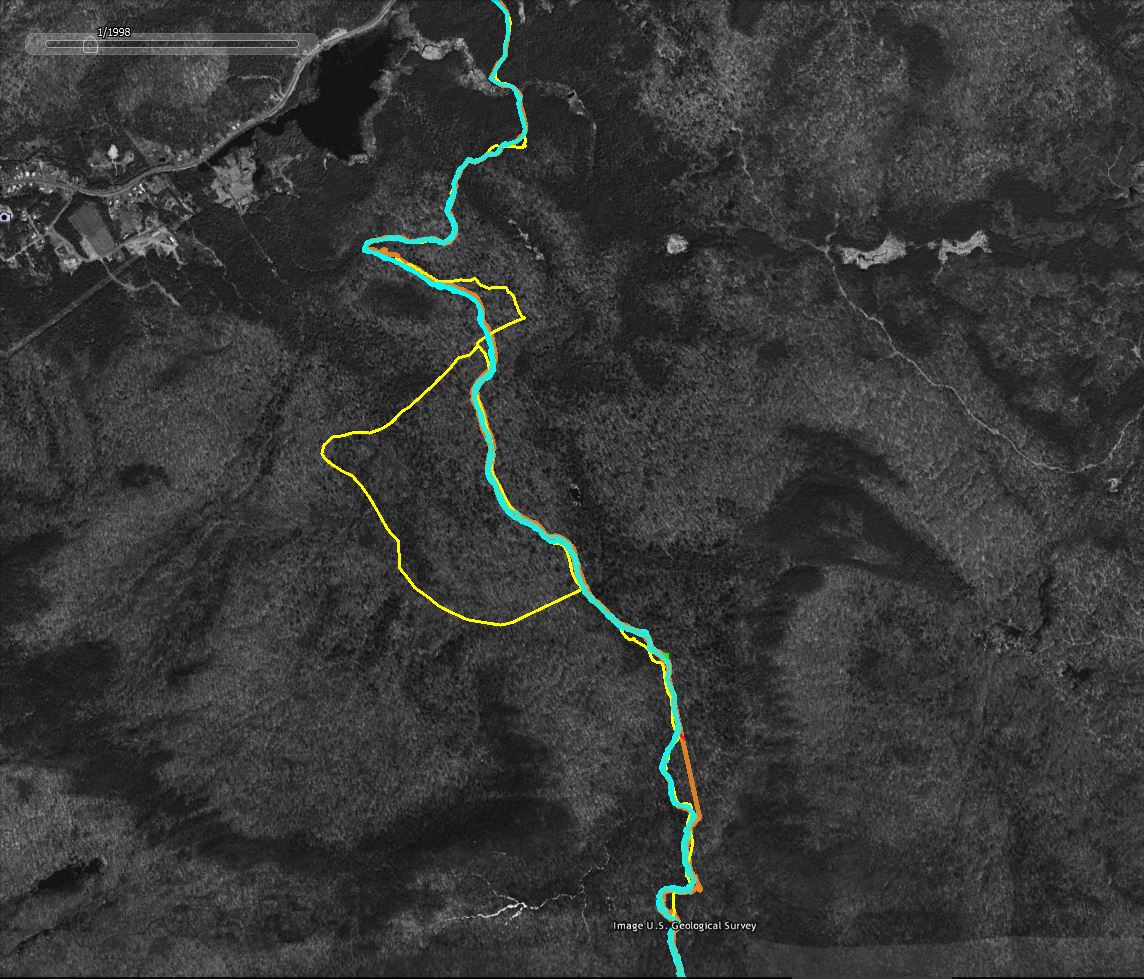
I've written about GPS accuracy in the past but nothing beats an example. The screen captures that follow (from Google Earth using historic imagery as the basemap) show how "accuracy" varies when using common GPS devices in the woods.
Legend:
  • Yellow Line: The trail as represented in the downloadable DEC Hiking Trails file. I don't know how DEC created the trails file but in many areas it shows only an approximation of route the trails actually take.
  • Cyan Line: The track captured by my Garmin GPSMap64 GPS Receiver. This was an out and back hike, so the two lines represent the trip up the mountain and return trip back down. Because I was snow shoeing in deep snow the two tracks should, in theory, overlap. I stayed in the trail I broke on the way up on the return trip.
  • Orange Line: The track captured using the GPS app on my phone. The two lines show the out and back routes as described above.
  • The Red Line is a high accuracy representation of the route. You can't see it in these images but the trail in the area shown follows an old woods road and it is possible to make out the route in the Google Earth imagery. The red line was traced from the image and should closely follow the actual route on the ground.
  • The horizontal green line; For scale, the green line represents a distance of 60 feet on the ground.


A section of the route overlaid with two sets of GPS tracks (the out and back tracks from two separate devices). The yellow line is less accurate representation from the DEC Trails download. The red line closely follows the actual route as traced from the image. 


Same as above with the less accurate tracks captured using the phone GPS hidden. The blue lines --tracks captured by a good consumer grade GPS unit-- vary by an average of 20 feet. The absolute variance from the traced representation of the trail (the red line) is also on average in 15-30 foot range. Larger variations might be the result of wandering off the trail at certain points.

For context, more of the followed route. The yellow "bulge" in the middle is a side trail off of the NLPT main route. The straight orange towards the bottom of the image is where the phone based GPS lost the GPS signal for a period of time. The straight line connects the points where the phone lost and later regained the signal.

Monday, June 6, 2016

New Trails at Lake Bonita, Moreau Lake State Park

In many parts of the U.S., Moreau Lake State Park would be a premier destination for hikers (those of us who live near the Adirondacks are totally spoiled). The park contains an extensive network of trails that pass over a varied and surprisingly rugged terrain. There are options for everything from short walks to ten mile mountain grinders. And those options just got better; much better. Two new trails have been built that integrate the 800 acres transferred to the park following the closing of the Mt. McGregor Correctional Facility and these new routes are particularly appealing.

Overview map of the new trails. from the parking area on Wilton Mountain Road it's 1.5 miles to Lake Anne. From there another mile of walking takes you to the main park trail system at junction 3. 

The new routes include a well designed trail that circles Lake Bonita --a lovely and distinctive small lake that was previously inaccessible to the public-- and a connection from the new trailhead on Wilton Mountain Road to the parks' existing trail system at Lake Anne. You can find the details of what is planned in the Office of Parks, Recreation & Historic Preservation (OPRHP) addendum the Moreau Lake State Park Master Plan. I'll probably have more to say about the newly added areas in the future but, for now, a few photos will have to suffice.


Lake Bonita from one of the spur trails that provide access to the waters edge. The shoreline of Lake Bonita is mostly undisturbed and OPRHP states that the lake is free of aquatic invasives; a rarity these days. The master plan details the agency's intent to protect these attributes of the lake. Boats of any kind are prohibited and no live baits are allowed for fishing.

Lake Anne: This lovely small "bog lake" boast floating bog mats that are uncommon this far south. No fishing is allowed in Lake Anne and, given that the lake is shallow and has a measured pH of 4.3, it's doubtful that any fish could survive in its' waters. 

Extensive swamps surround Lake Anne. If you like swamps as both I and biting insects do, these are wondrous places. 

The connection from Lake Anne to the parks existing trail system opens the potential for long loop hikes along Palmertown ridge. The southern Adirondacks from one of the many viewpoints along the West Ridge Trail.

Looping back over the East Ridge trail you'll pass through some of the most rugged and wildest sections of the park.

Back at Lake Anne. There is a pretty decent lean-to near Lake Anne. The spot is attractive and the parks' plans call for allowing backcountry camping at this site. You would probably not want to do that in June however. Just trust me on that point. 


Lake Bonita

Lake Bonita

Lake Bonita from the dam.


Wednesday, January 20, 2016

Along the Hudson and a new GPS Receiver

In this post I'm going to touch on three regular topics for this blog:
  • Hiking in Moreau Lake State Park (MLSP)
  • Old Trees
  • GPS Technologies
Looking across the Hudson towards the Palmertown ridge (and the main body of Moreau Lake State Park). Spier Falls Road is visible in the foreground on the far shore.
I got out yesterday (Jan. 18, 2016) for a hike on the east side of the Hudson River in Moreau Lake State Park (MLSP). Starting at an informal parking area on Call Street (between Queensbury and Corinth) this was a bushwhacking trip of just under six miles (round trip). Even so, it was a rather tough day. It was cold (mid-teens at best), the ground was covered with a layer of solid ice with an inch of snow on top and, and the route crossed a series of deep ravines cut by the streams that flow down from the surrounding hills into the Hudson. Only the last mile; from the point opposite the Sherman Island boat launch on Spier Falls Road to the Spier Falls dam itself was easy walking. Worth mentioning is that I could not have made this trip without the "micro-spikes" that I now carry on all Winter outings. These "boot chains" have exceeded my expectations at every use (available from many sources, here is one). 

The area in question is across the Hudson River from the main body of MLSP and it is little known and little used. Probably the best access is from Hawk Road (previous post here), but parking at Hawk Road is a problem in the Winter and it's a lengthy walk from there to the section east of Spier Falls dam. This area is not wilderness by any stretch, but it is wild and in places the terrain is very rough. There are numerous old logging roads and places once cleared for agriculture throughout this section and the foundations of abandoned structures are seen in several places. 

Foundation of an abandoned structure. The area around this foundation is relatively level and large enough for a field or pasture. The stand of same size trees indicates that this was cleared land in the past. Judging from the size of the trees, that was not the distant past. The agricultural use of this land was likely abandoned only in the past 30 to 40 years.

An ancient Maple

On the fringe of a once cleared agricultural area I came across a tree that has got to be one of the oldest in Moreau Lake State Park. It's a Sugar Maple (I think, mid-winter ID), and this tree is clearly in its twilight years. I didn't have my tape measure with me, but it is easily four feet in diameter. 

Sugar Maples can live to be over 300 years old and a tree of this size, with bark weathered and aged in this way, could be in that category.

This tree was located at the edge of an area that was probably cleared for grazing. And that's a common scenario for witness trees in the northeast. When the land was initially cleared trees growing along the edges of fields and pastures, and along stone walls, were left in place and became part of the agricultural landscape.

GPS - Garmin GPSMap 64S

One of my purposes for this outing was to put my new GPS receiver to the test. I've just purchased a Garmin GPSMap 64S. I've been thinking about acquiring a new GPS receiver for a while, but nothing I was seeing justified the cost. Then the clever robots at Amazon dropped an ad for the 64S on a web page I was viewing. At $230 the deal was too good to pass up.

Initial testing at Spa State Park over the weekend looked very promising, but I really wanted to put the unit through its' paces on a longer hike through a forested area. Not surprisingly, the 64S produces superior results on every front. For one thing, it's easier to use; no small consideration when it's 15 degrees with a stiff breeze blowing in your face. And while it is slightly larger and heavier than the eTrex it has a much better antenna. This is important when operating in thick forests and steep terrain.

It's not trivial to compare the accuracy of GPS units, at least not in the under $1000 dollar category where you have limited control over which satellites the receiver makes use of, but 64S has several features that should provide better and more consistent accuracy. The GPSMap 64 series receivers can make use of both the US GPS system as well as the Russian GLONASS satellites. All other things being equal more satellites should produce better results. The 64S is also capable of using the WAAS/EGNOS ground correction system. That's a big topic in its' own right and I'll discuss that further in a future post.

There are also a number of feature improvements, the most significant of which is that the 64S allows you to control the frequency at which it stores new locations when recording a track. This particularly useful when recording hiking routes. I set the 64S to add a new point to the track at one meter intervals; meaning that as you move along it stores one point per meter of travel (it can also be set to use a time differential). Set in this way you get a lot of data but it produces a much more detailed route than I could previously capture. This also avoids the annoying problem that I encountered with my older Garmin unit. When I would stop for a break, or for lunch, the older unit would continue to add points to the route based on a time differential (every 15 seconds would be my guess). So you would end up with a large number of points clustered around the location where you stopped. These could be cleaned from the data, but it was one more step in the process of producing a clean representation of the route.

I'm working on a detailed comparison of the performance of the 64S with my older receivers but the summary is that I don't know how I was getting by before.

Moreau Lake State Park, east of the Hudson River. The light blue line is my route. The heavy red line is the boundary of the section of the park that lies east of the Hudson River. Call Street is represented by the yellow line. The main section of the Park is on the west side of the Hudson, and Moreau Lake is just out of the area of the image at the lower right corner.
  • Marker A: Parking on Call Street
  • Marker B: Stream Valley
  • Marker C: Spier Falls Dam
  • Marker D: Sherman Island boat launch site on the west side of the Hudson (for reference)
  • Marker E: The Hawk Road Area
You might notice from the map that I wandered outside of the Park boundary at one point. That was inadvertent. At that point along this route you have to get over a steep-sided gully. Steep enough that given the icy conditions it was a challenge to find a place to get across. Most of the year it would be easier to stay in the park and get through this section.

A Section of the route showing each point captured by the GPS. Click the image to see it at full size. The GPSMap 64S, set to add a point to the track at one meter intervals captures a highly detailed representation of the route. Map Images from Google Earth.


Wednesday, May 20, 2015

Moreau Lake State Park Boundary (KML) for Google Earth

This is a follow up to my recent post on the addition of lands formerly held by the McGregor Correctional facility to Moreau Lake State Park. That post included a map image with a rough outline of the newly added parcel. I've refined that boundary and saved it to a KMZ format file that can be opened in Google Earth/Maps.

Link to the Moreau Lake State Park Boundary File
https://drive.google.com/file/d/0B3QHBL0PwDqWZFpxSG9nYU1BY0E/view?usp=sharing

Clicking the link will open a new browser window (or tab) showing Google Maps with the boundary layer displayed as an overlay. You can also download the boundary from Google Maps by clicking the Download Button (down arrow icon) on the Google Maps toolbar. The file is in the KML/KMZ format native to Google Earth/Maps. If you have Google Earth installed on your computer you can double click the downloaded file it to open it.

Image 1: Moreau Lake State Park Boundary.
Note: These boundaries are approximate and not official in any way. (Base map source: Google Earth)
The red outline represents the boundary of the main section of Moreau Lake State Park. The newly added "Lake Bonita" section is shown in blue (lower left). The area in brown (near the top) is the section along the Hudson River and north of Spier Falls Road, The section with the green outline is the area east of the Hudson (previous post on this here).

Image 2: The same boundary outlines viewed as an overlay in Google Maps. 
Viewing the boundary layer in Google Maps you might wonder why the outlines I've provided don't match the park boundary shown tinted light green. Most striking is that Maps only shows the main section of the Park. Probably because the data that Google used as the basis for the parks layer was created before the section east of the river was added. That question of "when was the data created" also applies to the new Lake Bonita section. The boundary outline I've provided was digitized from images provided with the press release announcing the land transfer (so again, it is only approximate).

Perhaps the most interesting discrepancy is the area outside of the red outline seen just below and left of Moreau Lake. That's not newly added so, is it in the park or outside of the park? It's probably a data error in Google Maps. No other source that I've seen includes that acreage in the Park and if you zoom in, as seen in Image 3, we see that there are streets located there. I know from having been there that there are houses on those streets so that area is probably not inside the State Park.

Image 3: The section in green, but outside of the red outline, is probably a data error. (Source Google Maps)
The outlines I've shared were digitized from base map layers obtained from several sources. My starting point was the official Park map and I edited and added detail using a base map layer from ArcGIS Online (Esri). My point in discussing these discrepancies is that geographic data usually represents a moment in time. If our subject of interest is represented by data that changes continuously then we can consider that data to be out-of-date the second we save it to a database. Even something far less dynamic --a State Park boundary for example-- will change over time and representations provided by varied sources will not necessarily be in agreement. And then there are errors of all kinds and the question of accuracy. But that's another whole story.

As a representation of the real world geographic data is uncertain. And uncertain is not the opposite of certain. It's a lot more complicated than that.


Monday, May 11, 2015

Lake Bonita - Moreau Lake State Park

It's not every day that a favorite local State Park has a good sized chunk of land added on. Especially when that addition includes an attractive lake that was previously off limits. But this is exactly what has happened at Moreau Lake State park. It was announced last week (May 2015) that 750 acres formerly controlled by the Mount McGregor Correctional Facility have been added to the park (official press release here).

A rough map of the area added to Moreau Lake State Park. The light blue outline shows the approximate boundary of the addition. Lake Bonita lies entirely inside the newly added parcel as does the Grant Cottage historic site. The red line represents the previous Park boundary and the colored lines inside that boundary show existing trails. Wilton Road passes through the addition and the prominent forest cut that intersects with Lake Bonita (from the top of the map) is an abandoned power line right of way. The even more prominent straight cut (gap in the forest) is a current power line ROW.  The buildings and infrastructure of the former correctional facility were not added to the park pending possible redevelopment. Note that the new parcel outline shown in this map was drawn by hand and is only approximate. The map is from Google Earth.

The minimum security Mount McGregor facility was closed in 2014 by New York State in a cost cutting move. Given that the 1100 acre Corrections property is mostly forested --and that it shared a 1.5 mile long boundary with Moreau Lake State Park-- the possibility that some portion might be added to the park received immediate local interest and support. Best of all, the corrections property included all of Lake Bonita. Lake Bonita is a 50 acre reservoir backed up by 150 foot long earth and rock fill dam across the headwaters of Beaver Brook (information on the dam). The lake is quite attractive and during a short visit on May 10th (2015) we saw a variety of water loving birds and what appeared to be Rock Bass spawning near the shore.

But the lake's most appealing characteristic is that it is undeveloped. A well maintained gravel road reaches the dam from Wilton Road and a second road reaches the east end of the lake from the former McGregor facility. The lake was the water supply for the prison and a pump house at that point is the only building visible on the entire lake shoreline.

The press release announcing the land transfer from Corrections to the State Park system noted that access is currently limited by a lack of parking and the absence of trails. We took that to mean that it's OK to visit if you can get there. Which is not to difficult if you are willing to hike and do a little bushwhacking. Probably the easiest way to visit right now is to hike the existing trail from Spier Falls Road to Lake Anne. Lake Anne sits right on the old property line between the Park and the Corrections department lands. From Lake Anne it is about 3/4 of a mile cross country to Lake Bonita. The only challenging part was getting around the extensive marsh found at the southeast end of Lake Anne. You could walk for a ways and then turn towards the lake, but it's been so dry that we went straight through it. We managed to keep our feet dry but we picked up a few hitchhikers while beating through the underbrush. Tick precautions are required if you go off trail anywhere in Moreau State Park.

Looking down the lake from near the east end. The dam is out of sight around the corner to the right.

Lake Bonita from near the dam. The lake is approximately half a mile long and 300 yards across at the widest point.


The dam on the northwest end of Lake Bonita.


History of Mount McGregor Part 1
History of Mount McGregor Part 2

Saturday, October 18, 2014

Moreau Lake - East of the Hudson -StoneWall Trail

The Hudson River splits Moreau Lake State Park (MLSP) into two sections. The main body of the park --where Moreau Lake is located-- is west of the Hudson River. However, a good sized chunk of park lies east of the river and coming from Saratoga Springs you must cross the Hudson to get there. Confusing the issue is that the Hudson makes a 90 degree turn and flows northeast through the park. So a hiker viewing the Hudson from the Palmertown Ridge is looking west toward the section of the park that is east of the river.

Moreau Lake State Park; The eastern section is on the left in this image of the park trail map.
To reach this eastern section of the park from Saratoga Springs take route 9N to Corinth. Cross the river and drive north for a half mile to the intersection with Call Street.  Turn right onto Call Street. About three miles from that intersection you'll see Hawk Road on the right (one sign says Hawk Street but it is Hawk Road). The first half mile of Hawk Road is paved but you'll quickly reach a steel gate where a sign reads; "Trailhead Parking Straight Ahead". From there it's about a mile on a one lane dirt road to the large parking area. As of October 2014 the road was passable for normal passenger cars with just a couple of rough spots.

The Stonewall trail --with Blue Markers-- leaves the west side of the parking lot (on your right as you drive into the lot). A second blue marked trail leaves the lot on the opposite northeast side. That trail is not seen on park maps that I have but it's a nice addition to the trail system. It makes possible a very pleasant loop hike of about 2.5 miles. The far point of the loop is near the Hudson at a spot where some 19th century building foundations remain. Making the "loop" is a bit confusing because, as mentioned, not all of the trails appear on the current trail maps. Even so, it's easy country to navigate and the continuation of Hawk Road (abandoned) crosses the trail at a couple of points making it possible to return to the parking area by that route.

Through the trees - the Spier Falls reservoir (Hudson River) 
This "Hawk Road Trail" (a name I just made up) also reaches the Hudson; but at a point further downstream just above the Spier Falls dam. From there the trail/road continues to the power line right-of-way leaving the power station at Spier Falls. The trail runs along the right-of-way as part of the canoe portage route around the Spier Falls dam. Canoeists approaching the dam from above leave the water and climb up to the road, follow a short stretch to Hawk Road to the right of way, and return to the water walking downhill under the power line. At that point you are on the upper section of a second reservoir backed up behind the Sherman Island dam about 3 miles further downstream. The hiking trail continues along the east bank of this reservoir for a couple more miles, but the transition between the two sections is heavily overgrown and serious tick precautions will be needed to get through unscathed.

Also worth mentioning is that this entire area is open to hunting and I ran into two hunters on my recent outing there. They politely handled their guns in a way that was safety aware but you should wear bright colors if you hike during hunting season.

As with the better known trails on the west side of the river, these trails offer a wealth of natural and human history to consider as you walk. I got a clear look at a male Red Bellied Woodpecker (Melanerpes carolinus). This species is distinctive and common in many eastern forests, but MLSP is a bit north of its' historic range. Which begs the question of whether this species is expanding its' range northward. And if so, why? Birds are able to respond to changing environmental conditions at a faster rate than many animals and plants (flying comes in real handy). So shifts in bird ranges can serve as an early indicator of changing ecological conditions. If the normal range of the Red Bellied Woodpecker is shifting northward it could be in response to a warming climate. But to make that assertion we need to know the natural history of this species for this area. Has the Red Bellied Woodpecker been present here in the past? If not, when did it arrive and what environmental/ecological changes make the area attractive now?

A less positive indicator of changing environmental conditions is seen in the extensive infestations of Asiatic Bittersweet (AB) along the section of Hawk Road that runs above Spier Falls dam. That AB is present here is hardly surprising. I had previously spotted AB from my canoe; at a place along the river/reservoir bank just below this section of trail. This area has been extensively altered by human activity and once it is present AB thrives where people disturb the forest and create forest edges. AB is common along a half mile stretch of the old road above the dam but I did not spot in the wilder forest areas. It would be interesting to survey the surrounding forest to determine the extent to which it has spread.
Asiatic Bittersweet along the (abandoned) section of Hawk Road near Spier Falls Dam.
Asiatic Bittersweet grows in dense stands that crowd out other vegetation and its' bulk can pull down trees. There is a similar native species; American Bittersweet. The two are easy to tell apart in the fall when the berries are present. If the berries grow all along a stem, it is the Asiatic variety. American Bittersweet has berries only at the ends of stems. Complicating matters is that the two varieties hybridize easily.
To round out my recent day of hiking I took a bush-whacking side excursion from the Hawk Road parking area down to the point where Bennie Brook flows into the Hudson (about 3/4 of a mile). Two things stand out from this little adventure. First, don't try to walk along the edge of the reservoir. It is really tough going and the dreaded deer (black legged) ticks --that carry Lyme disease-- are definitely present. The second point is that I did find something interesting along way; a very large White Oak, diameter 47 inches at chest height. This is probably the largest tree (by this measure) that I've seen anywhere in Moreau Lake State Park. And, because White Oaks are long lived, it could be the oldest as well. White Oaks can live to be 300+ years old and I'd love to know if this tree is really old, having somehow escaped logging, fires and other mishaps. Or is it a younger tree, maybe in the 150 year range, that just happened to grow under particularly favorable conditions. So many questions so little time.