Dishrag Pond, Extremely Remote and Exceptionally Shallow
Dishrag Pond appears on modern maps as a tiny blue dot deep in the heart of the Blue Ridge Wilderness. The pond made its' first appearance on USGS topographic maps in the 1950s and that curious name has been on the list of Adirondack ponds ever since. The Blue Ridge Wilderness Master Plan (1) contains a single paragraph which describes the pond as extremely remote, devoid of fish, and exceptionally shallow. Historical images from Google Earth show a small body of water at the location but images from August 2015 show a mud flat surrounded by a swampy perimeter. A perfect destination for a hike.
Screen capture from Google Earth showing the pond as it appeared in August 2015. The Blue Ridge Wilderness Master Plan notes that the pond is exceptionally shallow with an average depth of one foot. From that it's reasonable to guess that the 'pond' goes missing when conditions are dry.
My plan was to walk the Northville Lake Placid Trail (NLPT) north from Wakely Pond (2) to intersect with a unmarked path that runs up the valley toward Dishrag pond (3). That path follows the route of a long abandoned woods road that ran from the Cedar River Road to the headwaters of Brown's Brook. It's just under five miles on the NLPT to the intersection and an additional 2.5 miles up the drainage to the vicinity of Dishrag Pond. All was going according to plan until I reached the crossing of Brown's Brook where the bridge is partially out.
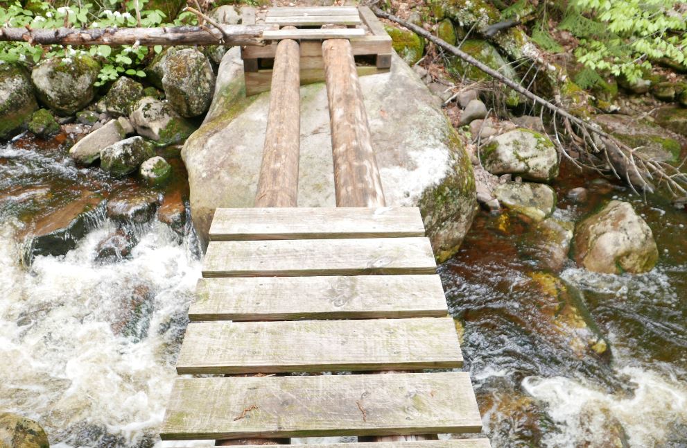
The NLPT bridge crossing Brown's Brook is missing half its' planking. It's not evident how it got into this state since it's a relatively new bridge; this section of trail was opened in just the last ten years. When the water is low you can rock hop to cross the brook and, if the logs are dry, you might chose to walk across the beams. On this day the logs were damp and slippery and I was not prepared to wade. So I headed up stream to find a place where I could get across with dry feet. On the way back I crossed the broken section of the bridge on my hands and knees using my hiking pole as a brace. It was not graceful but at that point I was not looking for style points.
Normally you might bypass the bridge and rock hop to cross the stream but two days of heavy rain had the brook running hard. I also considered walking the exposed logs but they were damp and slippery. Since I would be going up the valley anyway I figured the best bet would be to bushwhack along the stream until I found a place where I could cross. The first complication with that plan was that the banks of the brook are quite steep just above the bridge. So headed back up the trail to find a better spot to rejoin the brook. Eventually I did scramble down to the brook to take a look but the near bank was still quite steep and it was bordered by thick brush. Not ideal. More bushwhacking upstream expended a lot of energy but eventually I was able to get across with dry feet. My advice? Be prepared to wade this stream unless you know that the water is low.
A dense spruce thicket lines the north bank of Brown's Brook for a considerable distance above the NLPT bridge. It's a good 100 yards through this thicket before you emerge in the more open forest that lies beyond.
Getting to the far side of the brook revealed the next challenge. A spruce thicket lines the north bank of Brown's Brook and it took several minutes to find a way through and reach the open hardwood forest beyond. The spruce thicket along Brown's Brook is extensive and large spruce are present in the forest all the way to Dishrag Pond. This is notable because spruce were highly prized by loggers working this country in the early days of Adirondack logging. The abandoned road I would eventually find is seen on the first USGS map of the area published in 1903 and that probably means the area was logged before that date. The large spruce present today might have been too small to bother with back then and the passage of over 100 years has allowed them to reach mature sizes today.
The route to Dishrag Pond from the NLPT
Coming out of the band of dense growth along the brook I was unsure how far it was to the old road. Since I would be going up the valley either way I hedged my bets and set out towards a large unnamed vly that sits half way between the NLPT and Dishrag Pond. Following this course I would eventually reach the vly or find the path. After forty five minutes of bushwhacking pushed through a wall of brush I stepped out onto a clearly defined woods road. I'd hit the path at the point where the road forded the brook that flows out of the vly. The path, the brook and the vly came into view at the same time as did clarity as to where I was. A few minutes earlier I had thought that I'd have to give up on Dishrag Pond because of a lack of time, but this changed everything. The way was now clear. I could follow the old road to see where it goes.
The old road just above where it fords the brook flowing from the unnamed vly. Until I stepped out on to it I was not sure how distinct the way would be. This would be hard to miss.
Looking down the vly from the western end. This point is easily reached from the abandoned road that passes south of the vly.
From the vly to the vicinity of Dishrag pond the road is easy to follow but not easy going. Blowdown blocks the way in numerous places and the surface was consistently wet and muddy. Even so, I made decent time and just as I was starting to think that I must be getting close I rounded a bend to see the rusted hulk of a long abandoned car. The Ford coupe (I think from around 1940) had probably broken down at that spot and it has remained there ever since.
This abandoned car at the end of the old woods road provides known location for orienting yourself for the final push through the forest to Dishrag Pond. It appears to be a 1940 Ford Coupe and it probably broke down at this spot and was abandoned.
Just past the car the road ends. The 1903 USGS map shows the road reaching a small water body. If that was correct then the final stretch of road has been completely reclaimed by the forest. I couldn't tell exactly where the pond lay in relation to where I was, but, having come so far, I took my best guess and headed off through the forest one more time. What I learned is that the quarter mile between the end of the road and the string of beaver meadows below Dishrag pond is wet, very rough, and extremely thick. I hoping for at least a glimpse of Dishrag Pond but it was not to be. The pond couldn't have been more than a few hundred yards away, but it was 2:00 pm and getting there was going to take a while. So I turned for home. I'm unusually pretty good at retracing my steps through the woods and I tried to return to the spot where I had left the road. But even that proved to be difficult. As I said, the terrain is rough and the cover is exceptionally thick.
Looking across one of the beaver swamp/meadows just downstream from Dishrag Pond. The Blue Ridge is seen in the background.
If you want to reach Dishrag Pond leave the road 300 yards back from the place where you find the old car. Head north north west and stay in the hardwoods for as long as you can. I may have to return some day to see what Dishrag Pond actually looks like.
(1) Blue Ridge Wilderness Master Plan
(2) There is limited parking for the NLPT north at a pull-out on the Cedar River Road at Wakely Pond, The NLPT leaves the road at that point and enters the woods on a gravel road that can be driven a short distance to a pull out where additional cars can be parked.
(3) Current maps so the route as an unmarked path that ends at the vly halfway to Dishrag Pond. In fact it's an old woods road easily followed to a point a quarter mile from the pond.