Wednesday, May 27, 2015

Siamese Lakes Wilderness - Big Shanty River Driving Camp

Memorial Day; May, 25th, 2015. A thirteen mile round trip hike into the northern half of the 114,000 acre Siamese Ponds Wilderness. From Rte. 28 in North Hudson, turn (west) at the DEC sign for the Siamese Ponds Wilderness and Thirteenth Lake. Follow the signs to the "Old Farm Clearing" trail-head. There is a large parking area.

The "Old Farm Clearing" trailhead is a major access point for the Siamese Ponds Wilderness. My plan was to follow the main Sacandaga East Branch trail approximately seven miles to the suspension bridge that provides access to to the ponds for which the Wilderness area is named. There's a Lean-to near the bridge but nothing special about that location. It just seemed like a good turn around point and seven miles (each way) was fairly ambitious for this time of year.

I  didn't make it quite that far. Over the past few years my hiking mode has evolved into a slow (but steady) ramble through the forest. I peer into the woods looking for trees that are not like the others, plants that shouldn't be where they are, birds, other wildlife, unusual rock outcropping, signs of past human activity, elves and whatever else catches my eye. I take a lot of little side jaunts when I spot something interesting. So even though I left the car at 9:30 I had not reached the lean-to by my 1:30 turn around time. I figured I had maybe three-quarters of a mile left to go on the seven mile distance.

Not reaching the lean-to was of no concern but I was on the lookout for a sign for the "Big Shanty Lumber Driving Camp" mentioned in the 1994 edition of the ADK Guide to Trails of the Central Adirondacks. I didn't have the book with me but I thought it was located about a mile from the lean-to. If that was true, then I should have reached it. Of course, it might have fallen down or it might have been removed by a Hun or Vandal. And not knowing exactly where it was located, or even what it looked like, I might have simply missed it.

Oh well, time to turn back. Except, I could see a small clearing just 50 another yards down the trail. This one looked to be no different than a half-dozen others passed along the way. But why not, I decided to go just that bit further. And there it was, 20 feet off the trail. Just as the ADK book described it, large and rustic.

Big Shanty River Driving Camp, 1890.
I'd love to know the story behind this sign. Based on the rate of decay in the Adirondack forest it couldn't be more than 30 or 40 years old. But that's just a guess. If anyone knows more about this sign, and who put it up, please leave me a comment.

As for the rest of the hike, it was your standard late May outing in the Adirondacks. I participated in the annual Black Fly Count. And having encountered only a few thousand I can say with confidence that Black Fly numbers are way down this year. Or maybe the little buggers are just bidding their time. Waiting for warmer and wetter weather.

The Old Farm Clearing. There was some kind of tree farm surrounding this location and the clearing is well on its' way to filling in.

There are stands of  large hardwoods, including this Maple, along the trail. What I would call large second growth. Based on size and the bark I'd estimate this tree to be at least 150 years old. If so it would have been a small tree when this land was logged in the later part of the nineteenth century.

From the bridge over the East Branch of the Sacandaga River. Very low water following six weeks of dry weather.

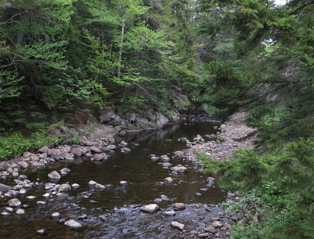
East Branch of the Sacandaga (looking north) from near the Big Shanty sign.
Flood plain of the East Branch a couple of miles upstream from the Lean-to and suspension bridge. Very low water 
There are a few very large White Pine scattered through the forest along the river. This tree has to be 150 years old or older. How did it escape the loggers saw? Maybe they weren't interested in White Pine at that time.


Wednesday, May 20, 2015

Moreau Lake State Park Boundary (KML) for Google Earth

This is a follow up to my recent post on the addition of lands formerly held by the McGregor Correctional facility to Moreau Lake State Park. That post included a map image with a rough outline of the newly added parcel. I've refined that boundary and saved it to a KMZ format file that can be opened in Google Earth/Maps.

Link to the Moreau Lake State Park Boundary File
https://drive.google.com/file/d/0B3QHBL0PwDqWZFpxSG9nYU1BY0E/view?usp=sharing

Clicking the link will open a new browser window (or tab) showing Google Maps with the boundary layer displayed as an overlay. You can also download the boundary from Google Maps by clicking the Download Button (down arrow icon) on the Google Maps toolbar. The file is in the KML/KMZ format native to Google Earth/Maps. If you have Google Earth installed on your computer you can double click the downloaded file it to open it.

Image 1: Moreau Lake State Park Boundary.
Note: These boundaries are approximate and not official in any way. (Base map source: Google Earth)
The red outline represents the boundary of the main section of Moreau Lake State Park. The newly added "Lake Bonita" section is shown in blue (lower left). The area in brown (near the top) is the section along the Hudson River and north of Spier Falls Road, The section with the green outline is the area east of the Hudson (previous post on this here).

Image 2: The same boundary outlines viewed as an overlay in Google Maps. 
Viewing the boundary layer in Google Maps you might wonder why the outlines I've provided don't match the park boundary shown tinted light green. Most striking is that Maps only shows the main section of the Park. Probably because the data that Google used as the basis for the parks layer was created before the section east of the river was added. That question of "when was the data created" also applies to the new Lake Bonita section. The boundary outline I've provided was digitized from images provided with the press release announcing the land transfer (so again, it is only approximate).

Perhaps the most interesting discrepancy is the area outside of the red outline seen just below and left of Moreau Lake. That's not newly added so, is it in the park or outside of the park? It's probably a data error in Google Maps. No other source that I've seen includes that acreage in the Park and if you zoom in, as seen in Image 3, we see that there are streets located there. I know from having been there that there are houses on those streets so that area is probably not inside the State Park.

Image 3: The section in green, but outside of the red outline, is probably a data error. (Source Google Maps)
The outlines I've shared were digitized from base map layers obtained from several sources. My starting point was the official Park map and I edited and added detail using a base map layer from ArcGIS Online (Esri). My point in discussing these discrepancies is that geographic data usually represents a moment in time. If our subject of interest is represented by data that changes continuously then we can consider that data to be out-of-date the second we save it to a database. Even something far less dynamic --a State Park boundary for example-- will change over time and representations provided by varied sources will not necessarily be in agreement. And then there are errors of all kinds and the question of accuracy. But that's another whole story.

As a representation of the real world geographic data is uncertain. And uncertain is not the opposite of certain. It's a lot more complicated than that.


Monday, May 11, 2015

Lake Bonita - Moreau Lake State Park

It's not every day that a favorite local State Park has a good sized chunk of land added on. Especially when that addition includes an attractive lake that was previously off limits. But this is exactly what has happened at Moreau Lake State park. It was announced last week (May 2015) that 750 acres formerly controlled by the Mount McGregor Correctional Facility have been added to the park (official press release here).

A rough map of the area added to Moreau Lake State Park. The light blue outline shows the approximate boundary of the addition. Lake Bonita lies entirely inside the newly added parcel as does the Grant Cottage historic site. The red line represents the previous Park boundary and the colored lines inside that boundary show existing trails. Wilton Road passes through the addition and the prominent forest cut that intersects with Lake Bonita (from the top of the map) is an abandoned power line right of way. The even more prominent straight cut (gap in the forest) is a current power line ROW.  The buildings and infrastructure of the former correctional facility were not added to the park pending possible redevelopment. Note that the new parcel outline shown in this map was drawn by hand and is only approximate. The map is from Google Earth.

The minimum security Mount McGregor facility was closed in 2014 by New York State in a cost cutting move. Given that the 1100 acre Corrections property is mostly forested --and that it shared a 1.5 mile long boundary with Moreau Lake State Park-- the possibility that some portion might be added to the park received immediate local interest and support. Best of all, the corrections property included all of Lake Bonita. Lake Bonita is a 50 acre reservoir backed up by 150 foot long earth and rock fill dam across the headwaters of Beaver Brook (information on the dam). The lake is quite attractive and during a short visit on May 10th (2015) we saw a variety of water loving birds and what appeared to be Rock Bass spawning near the shore.

But the lake's most appealing characteristic is that it is undeveloped. A well maintained gravel road reaches the dam from Wilton Road and a second road reaches the east end of the lake from the former McGregor facility. The lake was the water supply for the prison and a pump house at that point is the only building visible on the entire lake shoreline.

The press release announcing the land transfer from Corrections to the State Park system noted that access is currently limited by a lack of parking and the absence of trails. We took that to mean that it's OK to visit if you can get there. Which is not to difficult if you are willing to hike and do a little bushwhacking. Probably the easiest way to visit right now is to hike the existing trail from Spier Falls Road to Lake Anne. Lake Anne sits right on the old property line between the Park and the Corrections department lands. From Lake Anne it is about 3/4 of a mile cross country to Lake Bonita. The only challenging part was getting around the extensive marsh found at the southeast end of Lake Anne. You could walk for a ways and then turn towards the lake, but it's been so dry that we went straight through it. We managed to keep our feet dry but we picked up a few hitchhikers while beating through the underbrush. Tick precautions are required if you go off trail anywhere in Moreau State Park.

Looking down the lake from near the east end. The dam is out of sight around the corner to the right.

Lake Bonita from near the dam. The lake is approximately half a mile long and 300 yards across at the widest point.


The dam on the northwest end of Lake Bonita.


History of Mount McGregor Part 1
History of Mount McGregor Part 2