Our recent (partial) move to Long Lake makes it a lot easier to head out for a few hours and on the last two weekends I've done just that; kayaking on Little Tupper Lake for one outing and hiking Owls Head mountain on a separate day.
Little Tupper is the center piece of the William C. Whitney/Round Lake Wilderness area and the put-in is just a 20 minute drive from Long Lake Village. If canoeing or kayaking on wilderness lakes is your thing; it's hard to beat Little Tupper Lake.
Little Tupper is six miles long and averages about 3/4s of a mile across. It's a big lake, and its' alignment with the prevailing westerly winds means that it can get rough when the wind blows. As the signs at the wilderness headquarters note; if the wind starts to blow, or a thunderstorm approaches, head for the shore.
The day I was there was pretty calm and what wind there was came out of the south. This made it a good day to tool around in my little 'sport' kayak; not a boat you'd want to be out in on a day when the lake was roughed up. From the landing I paddled across the lake and then followed the south shore towards the lake's major inlet, Rock Pond Stream. As the crow flies it's about five miles from the headquarters to the head of the lake and, with some time added in for exploring, it took nearly two and half hours of steady paddling to get there. I had thoughts about continuing into Rock Pond Stream and possibly all the way to Rock Pond. But I didn't go far before the Black Flies and Mosquitoes convinced me that this was not a good plan. Besides, calm, sunny, morning had given way to increasing clouds and a freshening breeze. So it was time to head back. Working my way back along the northwestern (opposite) shore made for a round trip covering about 11 miles. A good workout in a 10 foot kayak designed for doodling around on small lakes and ponds.
Little Tupper hosts a solid loon population. This pair popped up close to my kayak and I was able to get off a couple of quick shots before they disappeared again.
Looking down the lake (to the northeast) towards the Ranger Station
Near the head of the lake, looking southwest. The inlet coming in from Rock Pond is maybe a mile further along the shore.
The stream from Rock Pond is easily navigable by canoe or kayak, with one short portage. Rock Pond itself is a large body of water and well worth a visit. But not on this early June day. Out on the lake the breeze was enough to keep the bugs away but close to shore the breeze dropped and bugs literally swarmed in. Run away!
Part Two: Owls Head Mountain
Owls Head mountain, with it prominent fire tower, is visible throughout the village of Long Lake. And the climb is a favorite of both visitors and residents. At just over three miles, with 1100 feet of elevation gain, this hike provides a sense of accomplishment without requiring a whole day.
And the views are well worth the effort. There are good views to the east, northeast and southeast from the rocks below the tower and a local volunteer group is maintaining the tower so you can climb up and get a nearly 360 degree vista. I don't know when (or if) the cab at the top of the tower is opened, but the highest landing provides clear views in all directions.
Blue Mountain, looking southeast from Owls Head. The south end of Long Lake in the foreground. South Pond is a bit further out towards Blue Mt.
Looking Northeast over Long Lake, the High Peaks in the distance.
Looking south from the tower it's an unbroken forest as far as you can see. You have to climb at least part way up the tower to enjoy this view.
The Owls Head tower is being maintained by a local volunteer group. Climbing up to the landing below the cab opens up views to the south and west that cannot be had from the ground.
Looking mostly south. Snowy Mountain is the dominant peak in the distant ridge.
The South Shore Horse Trail* starts at a large parking area just east of Little Tupper Lake on the Sabattis Circle Road (Hamilton County Rte. 10A). At the rear of the parking area a sign reads simply, "South Shore Trail 4 Miles". And that pretty much describes the route. This scantily marked trail follows abandoned logging roads into the emerging wilderness south of Little Tupper Lake. I walked the route on a snowy day in early December and winter is a good season for hiking in the Whitney Wilderness. In warmer months, this trail will be wet, in-grown and buggy.
One of several beaver disturbances that must be crossed along the way. Bands of heavy lake effect snow were falling on the day of my visit.
A large beaver pond just a mile from the road. When the water level is down you can easily cross the stream. At other times the dam itself can be crossed.
There is no specific destination for this walk in the woods. Signs point the way where old logging roads intersect but, after four miles, the trail simply fades into the forest. Leaving you two hundred yards short of Little Tupper Lake. You can access the lake shore at several points along the way but, right where the trail fades, reaching the water is a messy proposition. A tangle of blowdown, thick vegetation and beaver swamps will stand between you and the shoreline.
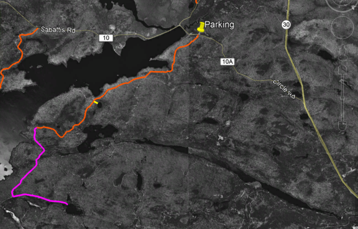
The full route shown overlaid on black and white imagery from 1994. The South Shore Horse trail is in orange. The short side trip to the unnamed pond is in Yellow. The possible extension to Doctors Pond is purple.
Beaver meadows near where the trail ends. To reach the lake pass this area on the left.
Little Tupper Lake looking southwest from a point near the end of the South Shore Trail.
I've previously written about the the network of trails that follow the northern shoreline of Little Tupper and provide access to the ponds southwest of the lake. Those routes, like the South Shore Trail, pass through, young, second growth woods. Most of the lands that make up the Whitney Wilderness were logged heavily in the years leading up to acquisition by the State and these woods will need decades to return to a pre-disturbance condition.
From another point on Little Tupper Lake, the view is towards the southwest.
While these two trail systems are in many ways similar I think that the South Shore Trail is more appealing. The South Shore route passes a series of swamps, marshes and beaver ponds all of which add interest to the route. Both routes have been blocked by beaver impoundments at multiple points, so plan on some wading at times of high water.
This small unnamed pond can be reached by bushwhacking from the trail. It appears that this pond is slowly filling in and appears to be headed for bog status in the future. Based on the vegetation that is present this is probably a good location for looking for boreal bird species.
An interesting short side trip can be made to visit a small pond that is slowly transitioning to a boreal bog. There's no trail to the pond but it's easy to find. At the 2.5 mile point the trail enters a large clearing where a small sign points out a 90 degree left turn. Just after reentering the woods a large abandoned culvert pipe can be seen left of the trail. This is a good place to head off to the east for the side trip to the pond. The pond is less than 200 yards away and can be reached in five minutes, even accounting for the blowdown and thick growth. The pond is entirely surrounded by bog vegetation: Labrador Tea, Tamarack, and insectivorous Pitcher plants.
If you are looking for something a little more adventurous, the South Shore Horse Trail could be used to set up a visit to Doctors Pond. A remote and little visited body of water lying in the southeast corner of the Wilderness. A possible route would leave the South Shore Horse Trail at an intersection where a sign --nearly lost in the encroaching forest-- says simply, "Trail". This intersection is about four miles from the parking area and just a quarter mile from Little Tupper Lake. A unmarked logging road bearing southeast from this intersection could provide the basis for such a route.
The possible route extension to Doctors Pond is represented by the purple line. This screen capture from Google Earth is overlaid on historic imagery from 1994. The many logging roads (abandoned with the state acquired the land in 1997.
After just a quarter mile this abandoned road runs into a complex of beaver ponds along the outlet stream that joins Stony Pond with Little Tupper Lake. From the point where the old road is blocked, it should be feasible to head west (towards Little Tupper Lake) to work around the wet areas. Rejoining to the old road on the far side, it appears that it could be followed for a mile to an intersection with other abandoned roads that ran from Little Tupper Lake to Doctors Pond. The total distance for this add-on is a little more than two miles and you would be wise to expect the route to be muddy with lots and lots of blowdown. Even so, following these abandoned roads is generally easier than bushwhacking.
NOTE: If you attempt a route like this you need a good map, a compass and knowledge of what you are doing. Navigating in country like this is much harder than it seems.
* The official Whitney Wilderness map produced by the NYS Department of Environmental Conservation shows this trail as the Stony Pond Trail. Not a great name given that Stony Pond is on Private Land and cannot be reached from this trail.
When the State established the Whitney and Round Lake Wilderness areas in 1998 some of abandoned logging roads that crisscross the area were marked as trails. And while I've canoed and camped on the big lakes that define this area: Little Tupper, Round Lake, Rock Pond and Lake Lila, I had never found a reason to hike those trails.
In part that's because before the former Whitney lands were added to the Forest Preserve the area was heavily logged and these forests will need another 50 years to recover their full stature. On top of that there's the issue of distance. Bum Pond, the closest of the destinations reached by trail, is over five miles from the trailhead and the other ponds you might want to visit require round trips in the 15 to 17 mile range.
But now I had a reason to go (which I'll get to in a minute). So, starting at the Burn Road parking area on the Sabitis Road, I set off for Hardigan Pond south of Little Tupper Lake. The Burn Road trail follows what was previously a well built logging road and its' purpose is to get you to the southern end of Little Tupper lake (which despite the name is six miles long). After about five miles on the Burn Road trail you reach the first of the side trails that can be taken to reach Bum Pond, Lilypad Pond, Rock Pond, and Hardigan Pond. You can also access the shore of Little Tupper itself at several points along the way.
My motivation for walking this route on a beautiful Sunday in July was rain. The preceding weeks had been exceptionally rainy, even by Adirondack standards, and trails everywhere were flooded and muddy. I knew that Charley Pond Stream, the only substantial stream in the first five mile stretch along the Burn Road, was spanned by a substantial bridge. With streams running at spring flood levels throughout the Adirondacks I figured the Burn Road would be relatively dry. Turns out, this was only partially true. On this particular weekend, the Adirondacks were soaked.
Charley Pond Stream just below the bridge on the Burn Road. The water on this day (7/2/2017) was exceptionally high following two weeks of heavy rains.
The bridge over Charley Pond Stream is just under four miles from the trailhead and a mile past the bridge the trail reaches the first junction. This side trail (also following what was once a gravel road) heads east toward Bum Pond and the former site of Bliss Camp on the south shore of Little Tupper Lake. The junction is marked by an ancient sign post with a homemade sign on which someone has written "Bliss", with an arrow pointing the way. Given that this is the only destination in the area likely to get any traffic, I should have realized that this might not be a good omen.
My intended destination was Hardigan Pond; a trek of 8.5 miles (each way). That's about my distance limit but old roads usually provide easier walking and, if conditions were good, I figured I could make it (and still be able to walk back out). But the extremely wet conditions posed challenges even on this relatively dry route. The first of which was a large beaver pond just two miles in. The pond covered an extended section of the trail and the rains had swelled the pond out into the forest in all directions. The terrain at the spot the beaver selected is particularly rough and rocky, and getting around the flooded area led me through a dense spruce thicket and I still got my feet wet crossing a large a marshy area. And this little detour ate up a lot of time.
Bum Pond, in the William C. Whitney Wilderness just south of Little Tupper Lake.
But an even bigger issue loomed past the Bum Pond junction. When these trails were laid out they followed well traveled gravel roads, and there was little need for marking. Today, after the passage of 20 years, waist high growth fills every clearing and the old logging roads that crisscross the area all look alike.
A mile past the Bum Pond/Bliss Camp junction the trail reaches a junction with the single DEC sign I spotted anywhere along this route. The sign pointed the way towards Rock Pond and Hardigan Pond and I knew that the route straight ahead continued on to Lillypad Pond. I headed towards Hardigan and, from that point on, there were no signs or trail markers. There was also no indications that anyone goes this way. Following the old road through the wooded sections was easy enough but at one large clearing brambles and weeds had filled in to the point that I was unsure which of the three old roads leaving the far side of the clearing was the actual trail. And I picked the wrong one. After a half mile I realized that I was heading in the wrong direction and turned back. Backtracking to the clearing, and coming at it from that alternate direction, the main route was obvious. Beginners mistake.
By now it was too late to make Hardigan Pond but there was one more complicating factor. Have you ever seen a movie from Siberia or Alaska with people surrounded by a cloud of mosquitoes? It was now early afternoon, and quite warm, and I must have been the tastiest creature to come this way in a while. Even drenched in deet the mosquitoes were attacking in waves and were way past being just annoying. It was time to head back.
Along the way I took the one mile side trip to Bum pond and the Bliss Camp site, and both are worth a visit. Resting and enjoying a swim in Little Tupper made the five+ miles back along the Burn Road much more enjoyable.
Bum Pond southwest of Little Tupper Lake.
Little Tupper Lake from the former Bliss Camp landing. Back in the 60s and 70s Bliss Camp was an in-holding in the Whitney property and a substantial "camp" (private home) was located at this spot. Later, a hunting and fishing club had a camp here as well. The buildings are long gone and, other than some open areas rapidly filling in with small trees and early successional growth you wouldn't know that buildings were once located here.
A small pool along the Burn Road was filled to the brim and based on the population of large polliwogs the local frog population will soon be greatly increased. I had stopped to try to get a picture of a snapping turtle that I noticed sitting on this submerged log, but the turtle spooked and all I could get were the soon to be frogs.
In one respect the Burn Road, and the young forests it passes through, are exceptional. This area is an excellent place to see wildlife and birds. Moose and bear had left calling cards along the trails and I saw a number of birds that are harder to spot in more mature forests.
Eastern BlueBirds (nesting)
Cedar Waxwings
Ravens
Yellow Bellied Sapsuckers
Turkey Vulture
Great Blue Heron
White Crowned Sparrows
Ruffed Grouse
And of course Blue Jays, thrushes and other ubiquitous species
Footnotes:
Locals refer to this as the Burn Road but the DEC calls this the Lillypad Pond Trail.
The Adirondack Atlas refers to it as the 'boreal core'. No hard boundaries define this region and you'd be hard pressed to name the characteristics that make it distinct. The presence of boreal species and assemblages is certainly part of it, but it's also weather patterns and the glacial landscape dotted with lakes, streams and swamps. Lots and lots of swamps. For me it's the just feel of the place. Traveling west out of Long Lake you enter a landscape that feels different from areas to the east and south. The eastern Adirondacks can lay claim to the scenery but the core has the wildness.
Recent additions to the Forest Preserve make it easier than ever to enjoy that wildness. From the Adirondack Hotel in Long Lake it's barely 20 minutes to the first canoe put-in for the William C. Whitney/Round Lake Wilderness. There is a ranger station and canoe put-in for Little Tupper Lake at the old Whitney Industries Headquarters (with lots of parking) but you can also put your canoe in the water right along the road where you first come to Little Tupper Lake (there is good parking). From there you can head downstream following the flow into Round Lake or cross under the bridge into Little Tupper. From our base in Long Lake Elle and I were able to take advantage of this easy access on successive days over the long 4th of July weekend.
Round Lake is a large lake; 750 acres, but it is overshadowed by its' even larger neighbors; Little Tupper and Lake Lila. Perhaps this is why we saw only a smattering of people over the course of our two visits. Or maybe it was the black flies and mosquitoes. There's no shortage of either of those species.
The great boreal forests of Canada reach a southern limit in the Adirondacks. Vast amounts of water and long cold winters are necessary to produce the conditions in which boreal species thrive.
One of the small islands on Round Lake. Like the others, this island is wind swept and fragile.
Pitcher Plants in one of the many bogs and swamps that ring the lake.
The lake is home to multiple pairs of loons. We also spotted a Bald Eagle soaring overhead, a Cooper's Hawk (most likely ID) Cedar Waxwings and other common Adirondack species.
What we used to call a Kodachrome moment.
I think this is Pickerelweed (Pontederia cordata).
Whatcha lookin at?
Dragon Flies are apparently attracted to pink. We know for sure that Black Flies are. Ellie's sweater seemed to collect them like a magnet.
You can just make out the dam on the outlet of Round Lake outlet. Click the picture to see the full size image. The dam comes in from the right (I'll try to get a better picture next time). The concrete dam is apparently just remnant of the original structure. My Dad worked on Whitney Park in the late 50s and early 60s and he tells me that at that time there were mechanisms to control the water level and a second wooden dam designed by Bert Stanton (my great uncle).The wooden dam is gone, and the concrete is eroding, but the remaining structure still raises the water level of Round Lake and of Little Tupper Lake. Looks like it raises the water level by only a couple of feet but, given the size of these two lakes, that's still a lot of water.
The Round Lake dam in an image captured from Google Earth. This view from downstream shows the remnant dam clearly coming into the flow from the left and you can see that the dam has been breached (intentionally???). The block of concrete seen in this image is the same one that you just make out in my photo (above). This image is from May of 2013 (according to the Google Earth metadata) at a time when the water level was well below the top of the concrete. My photo from July 6, 2015 was taken following a month of heavy rains and the water level in Round Lake was just an inch or so below the top of the concrete dam; a couple of feet higher than when this satellite image was made. That fits with what we had seen elsewhere on the lake. We already knew that Round Lake was just an inch or two below the high water marks visible on exposed rocks.