Saturday, December 23, 2017

Pharoah Lake Wilderness: Rock Pond

It's easy to forget that nearly a million acres of the Adirondack Forest Preserve lie east of the Northway (I-87). The eastern section includes Lake George, Schroon lake and the New York side of Lake Champlain; all significant attractions. But, for hikers, the undisputed crown jewel in the east is the 45,000 acre Pharaoh Lake Wilderness (PLW). The PLW encompasses mountains with open summits and boulder strewn slopes. Nestled among those peaks and ridges are some of the most attractive lakes and ponds in the Adirondacks. And the area was settled --and logged-- early on, so a matrix of surprisingly mature second-growth forest blankets the landscape. I've hiked in the PLW before but my last visit was over 20 years ago. So my recent walk to Rock Pond --4.5 miles via the Short Swing Trail-- was an eye opener. The Pharaoh Lake Wilderness is an outstanding hiking destination.

Honey Pond. A semi-permanent, shallow, pond. The size of the pond varies based on the vitality of the local beaver population. As of December 2017 the outlet is solidly dammed and the pond has flooded sections of the Short Swing trail  (getting around the wet areas is not difficult).

At these latitudes the late December sun never gets very high in the sky. This picture was taken near Lillypad pond at about 1:00 pm. 
As mentioned, I've hiked in the PLW before and this was a favorite destination for family hikes when our children were children. In fact it was at Pharaoh Lake, nearing the end of an epic, six day, family backpacking trip that our nine year old daughter uttered one of the most memorable lines in our family history;


"We've been here for a week, we are out of food, and our parents don't care."


We were getting low on food and she and her brother were sick of our freeze-dried fare. She used that line to extract granola bars from passing day hikers. Once Elle and I caught on we had to put a stop to her "gathering" activities. But I have to admit, we were all pretty sick of backpacker food at that point and I was tempted to let her keep trying.

Rock Pond has an attractive rocky shoreline. Via the Short Swing Trail and Lillypad Pond trail, it's about 4.5 miles to reach the western end of Rock Pond. A mile-long trail goes around the pond and a shorter approach can be made from Putnam Pond.
Major trails enter the PLW from several directions and easy access is part of the appeal of the PLW. Two trail with good parking are found along NY Route 74 between Paradox Lake and Eagle Lake. Other trails depart from the State Campground at Putnam Pond and several trails enter the PLW from the south. The PLW trail system is extensive so long looping routes are possible. There are 14 lean-tos located within the boundaries of the PLW, most sited near the numerous lakes and ponds.

Lillypad Pond lean-to. 
Lillypad Pond

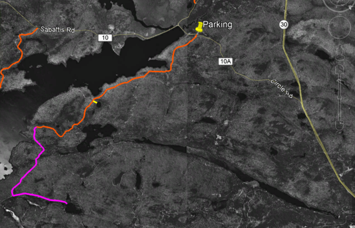
The GPS track showing my route to Rock Pond is shown in light blue. The orange lines represent trails are represented in the NYS Department of Environmental Conservation's downloadable trails map. The trails map is available as a KML file that can be viewed in Google earth. It can be downloaded from the DEC website.    
The map image shows my GPS track (light blue) overlaid on a trails layer (orange) that can be download from the New York State DEC website (displayed using Google Earth). I was curious why the GPS track is not more closely aligned with the trails from the DEC map layer. I would expect the GPS track to be accurate to around 30 feet. But the gap between my track, and the trails map layer route, are separated in places by as much as a quarter mile.

There are several potential sources for this type of discrepancy. One is that trails are commonly re-routed. A closer look at the start of the route (below) shows an example of this. It used to be that there was no parking at the trailhead for this route. There was a parking area .3 miles away but you walked along Route 74 to reach the start of the trail. Route 74 is a busy road, so a few years back DEC added a bypass trail through the woods. The map below shows that the DEC trails layer has not been updated to include this new section. The GPS track shows the highway bypass but the trails layer shows the route starting at the old entry point on the highway.


This provides a clue as to the source of the discrepancies between the GPS track and the trails layer route. It may simply be that the trail maps for the PLW have not been updated in some time. If those routes were drawn pre-GPS they were probably hand-drawn on a background map. That approach results in a lower accuracy.

DEC Roads and Trails (from the New York State GIS Clearinghouse)

Pharaoh Lake Wilderness DEC Site


Monday, December 11, 2017

Little Tupper Lake; The South Shore Horse Trail

The South Shore Horse Trail* starts at a large parking area just east of Little Tupper Lake on the Sabattis Circle Road (Hamilton County Rte. 10A). At the rear of the parking area a sign reads simply, "South Shore Trail 4 Miles". And that pretty much describes the route. This scantily marked trail follows  abandoned logging roads into the emerging wilderness south of Little Tupper Lake. I walked the route on a snowy day in early December and winter is a good season for hiking in the Whitney Wilderness. In warmer months, this trail will be wet, in-grown and buggy.

One of several beaver disturbances that must be crossed along the way. Bands of heavy lake effect snow were falling on the day of my visit.

A large beaver pond just a mile from the road. When the water level is down you can easily cross the stream. At other times the dam itself can be crossed.
There is no specific destination for this walk in the woods. Signs point the way where old logging roads intersect but, after four miles, the trail simply fades into the forest. Leaving you two hundred yards short of Little Tupper Lake. You can access the lake shore at several points along the way but, right where the trail fades, reaching the water is a messy proposition. A tangle of blowdown, thick vegetation and beaver swamps will stand between you and the shoreline.

The full route shown overlaid on black and white imagery from 1994. The South Shore Horse trail is in orange. The short side trip to the unnamed pond is in Yellow. The possible extension to Doctors Pond is purple.

Beaver meadows near where the trail ends. To reach the lake pass this area on the left.

Little Tupper Lake looking southwest from a point near the end of the South Shore Trail.
I've previously written about the the network of trails that follow the northern shoreline of Little Tupper and provide access to the ponds southwest of the lake. Those routes, like the South Shore Trail, pass through, young, second growth woods. Most of the lands that make up the Whitney Wilderness were logged heavily in the years leading up to acquisition by the State and these woods will need decades to return to a pre-disturbance condition.

From another point on Little Tupper Lake, the view is towards the southwest.
While these two trail systems are in many ways similar I think that the South Shore Trail is more appealing. The South Shore route passes a series of swamps, marshes and beaver ponds all of which add interest to the route. Both routes have been blocked by beaver impoundments at multiple points, so plan on some wading at times of high water.

This small unnamed pond can be reached by bushwhacking from the trail. It appears that this pond is slowly filling in and appears to be headed for bog status in the future. Based on the vegetation that is present this is probably a good location for looking for boreal bird species.  
An interesting short side trip can be made to visit a small pond that is slowly transitioning to a boreal bog. There's no trail to the pond but it's easy to find. At the 2.5 mile point the trail enters a large clearing where a small sign points out a 90 degree left turn. Just after reentering the woods a large abandoned culvert pipe can be seen left of the trail. This is a good place to head off to the east for the side trip to the pond. The pond is less than 200 yards away and can be reached in five minutes, even accounting for the blowdown and thick growth. The pond is entirely surrounded by bog vegetation: Labrador Tea, Tamarack, and insectivorous Pitcher plants.

If you are looking for something a little more adventurous, the South Shore Horse Trail could be used to set up a visit to Doctors Pond. A remote and little visited body of water lying in the southeast corner of the Wilderness. A possible route would leave the South Shore Horse Trail at an intersection where a sign --nearly lost in the encroaching forest-- says simply, "Trail". This intersection is about four miles from the parking area and just a quarter mile from Little Tupper Lake. A unmarked logging road bearing southeast from this intersection could provide the basis for such a route.

The possible route extension to Doctors Pond is represented by the purple line. This screen capture from Google Earth is overlaid on historic imagery from 1994. The many logging roads (abandoned with the state acquired the land in 1997. 
After just a quarter mile this abandoned road runs into a complex of beaver ponds along the outlet stream that joins Stony Pond with Little Tupper Lake. From the point where the old road is blocked, it should be feasible to head west (towards Little Tupper Lake) to work around the wet areas. Rejoining to the old road on the far side, it appears that it could be followed for a mile to an intersection with other abandoned roads that ran from Little Tupper Lake to Doctors Pond. The total distance for this add-on is a little more than two miles and you would be wise to expect the route to be muddy with lots and lots of blowdown. Even so, following these abandoned roads is generally easier than bushwhacking.

NOTE: If you attempt a route like this you need a good map, a compass and knowledge of what you are doing. Navigating in country like this is much harder than it seems. 


* The official Whitney Wilderness map produced by the NYS Department of Environmental Conservation shows this trail as the Stony Pond Trail. Not a great name given that Stony Pond is on Private Land and cannot be reached from this trail.

Saturday, November 25, 2017

The Tongue Mountain Range

Hikers love loop routes. And the Tongue Mountain Range, on the western shore of Lake George, offers just such an option. From the Clay Meadows trail head (on Rte. 9N) a trail ascends 1.5 miles to a junction with the Tongue Mountain Range trail. Heading south from that intersection, towards Montcalm Point, the trail crosses three named summits and 6.5 miles before reaching the Lake George shoreline. At Montcalm Point the trail intersects the Northwest Bay trail which can be followed for 5.5 miles back to the starting point.

Lake George from French Point Mountain. The late November light was attractive but the 30 mile per hour breeze was chilly.


This view from Google Earth exaggerates the three dimensional relief of the Tongue Mountain Range. But, it provides a good perspective on how you should approach this route. These peaks appear rounded when viewed from a distance but that belies the steepness of this rugged terrain.  
Few hikers would expect a route that covers 14 miles to be easy, but distance tells only part of the story for this hike. If you have not walked this trail you will underestimate the difficulty of this route.

The trail moves up or down continuously as it crosses the summits, knobs and bumps that make up the Tongue Mountain Range. And the terrain is raw and jagged, with a few really steep pitches thrown in for good measure. On my shortened version of the loop I racked up a cumulative elevation gain of 3500 feet. 

The Tongue Mountain Range trail system. The orange lines represent marked trails and the blue line is route I followed. I bailed out half way down the ridge and bushwhacked down to the lake shore where I was able to pick up the Northwest Bay trail for a return to the car. 
Getting a mid-morning start --in late November-- I knew that walking the entire route before dark was going to be a stretch (I do carry a good flashlight, and it has seen a lot of use). But I figured there would be easy sections where I could motor along and cover some of the miles quickly. However, a lunch-time check of the GPS revealed that I was mistaken. With the ground left to cover I would not complete the entire loop before dark. I could have turned back but that would have required going back up and over the steep little summits I had already crossed. My old knees were not crazy about that idea.

The Tongue Mountain Range juts into Lake George creating the 'Narrows' and separating the heavily developed lower lake from the wild and attractive northern section.
So, enter alternative option 'C', a shortcut!. From the map it looked to be easy to travel cross country from the low point in the ridge between French Point Mountain and First Peak and to intersect the Northwest Bay trail a couple of miles short of Montcalm Point. I never forget that shortcuts do not always work out as planned, but this was an easy decision. It would be downhill all the way and the trail I needed to find follows the shoreline of Lake George for several miles, so it would be virtually impossible to miss it. Not surprisingly, the terrain was rough, and the mile of bushwhacking needed to make the connection took nearly an hour. But, hoofing it back along the relatively flat Northwest bay trail did get me back the car at 4:30, with light to spare.

The ski Slopes on Gore Mountain were visible to the west. The recent cold weather has allowed for snow making.

The Tongue Mountain range is comprised of a half dozen modest summits with the highest point, the summit of Five Mile Mountain, at just over 2200 feet. But don't be deceived. The trail not just challenging, it also provides stunning views at numerous points. The eastern side of the ridge drops steeply to the shore of Lake George and the summit of Black Mountain, on the far side of the lake, is just three miles away (as the crow flies).
  
Looking across the lake, towards Black Mountain.
While the terrain is reminiscent of much larger mountains to the northwest, the forest composition reminded me of a favorite haunt that is much closer to home. The western slopes of the ridge bear a typical Oak-Hemlock forest and the wind-swept areas on top, and on the east side of the ridge, are forested with Chestnut Oak and White Pine. This is the same combination seen along the Palmertown Ridge in Moreau Lake State Park but not commonly seen elsewhere in the Adirondacks. I'm planning to go back for a closer look at the forest composition; the Tongue Mountain Range is worth another visit from that perspective alone. And next time I'll be better prepared. To complete this loop you need to take it seriously.

A closer look at Black Mountain on the Eastern shore of Lake George.

The Narrows, looking south

Looking southwest. Northwest Bay lies between the range and western shore of Lake George. The return trail for the full loop follows along this shoreline. Descending into the col between where this picture was taken, and First Peak, I turned left and headed down to the lake. 


Tuesday, September 26, 2017

Goatfell, Above the Clouds

We hiked up Goatfell yesterday and it was stunning. Goatfell is the highest mountain on the Isle of Arran (off the west coast of Scotland). The mountain stands at 2850 feet. Which seems quite modest until you factor in that the parking area where you start is 50 feet above sea level. The true tree line on Arran appears to lie at about 2000 feet, a little higher than over in the highlands, but like most of Scotland, where tress could grow, and where they do grow, are two different stories. It's three and half miles to the top of Goatfell and it's open vistas for the entire second half of that walk.

We started in brilliant sunshine, passed through thick clouds for a while and, then, as we got up higher, the skies cleared above and the fog settled in below. We stayed mostly above the clouds for the rest of the day. Ironically, the coast was socked in with dense fog. In the coastal villages it was a foggy, damp, day. Up on the mountain it was spectacular.

We walked very slowly and, as we neared the top, people who had passed us on the way up passed us again going the other way. I was a little concerned when we got to the top at 2:30. A young couple was on top when we got there and they were starting back down. We had the top of the mountain all to ourselves (I was wondering if they all knew something we didn't). But, no worries, after half an hour on top we started back down and passes a steady stream of still upward bound walkers.

These photos are not in any particular order. And for the best sense of the top of mountain, this YouTube video says it all. It's worth noting that there top is a fairly large flat area on top, but the mountain falls away steeply on all sides. In the video Elle was holding on to steady her wobbly knees. Wobbly from the exertion but also a little bit from the sense of exposure as the ground fell away in all directions.


It's hard to get a sense of scale from the photos. This screen capture from Google Earth should help. The marker on the left for Glen Rosa is at a point that is 300 feet above sea level. The summit of Goatfell is at 2850. The trail comes up from the right and it rises up from sea level. 


Looking northeast. You can see the highlands 50 miles away when it's clear. We did get that view later in the day. 

The south ridge of Goatfell slipped in and out of clouds as we climbed higher.

Similar to the picture above. Taken higher up after the clouds started to fall away.

From this point the route gains 700 feet of elevation in a quarter mile of distance. Just past where Elle is in the picture it starts to get very steep.

Looking northeast from the summit. Goatfell is surrounded by jagged ridges and slightly lower peaks.


Looking southeast from the summit. Glen Rosa is on the right. For scale, the ribbon of water seen at the far right is small river. The floor of the valley is 2300 feet below the summit.


By later in the day the clouds cleared (though it remained socked in below 500 feet all day). Looking backup at the summit. This picture gives a sense of the route. It crosses the rocky bump on the right and then goes straight up to the top.

Looking west from further down. The Isle of Arran is surprisingly mountainous. 

One last look back up at the top.

On the steep part, nearing the top. This ridge to North Goatfell is "not recommended for casual walkers." 


Our first look at the top taken in the morning. The summit was socked in at this point in the day.


Saturday, September 23, 2017

Rannoch Moor

Northern Scotland is not just mountains (and castles and adult beverages). We also visited Rannoch Moor. A moor is an area dominated by grasses or shrubs, usually wet, and characterized by highly acidic soil. Rannoch Moor is of the shrubland variety typically seen in Scotland and it is notable for it's size and for being very very wet. It is basically forty five square miles of bog.

We drove to Rannoch Station on the western edge of the moor. This tiny railway station would be the most isolated rail stop in the U.K., if not for Carnock Station. Carnock is ten miles further north and has no road access at all. 

It's hard to describe how isolated this place feels. It's ten miles on a road that is barely a car wide and that comes after the long, narrow, road along the shore of Loch Rannoch. Rannoch Moor is described as one of Europe's last great wildernesses and a sign at the parking area warns that the moor is not be trifled with. 

On the shore of Loch Laidon. One of several large bodies of water that are in or along the boundaries of Rannoch Moor.

Loch Laidon. We walked a couple of miles from Rannoch Station along a forest road that contours above the shore of Loch Laidon. The path is marked with a sign that says, Public Footpath to Glen Coe, 13 miles. This is not a heavily used trail.


Loch Rannoch. You drive alongside the Loch for ten miles before heading out on the six mile long, single lane, road to Rannoch Moor.  You pass one farm along the way.


A hill along the road to Rannoch Moor. It was an overcast day but the sub broke through a few times. The River Gaur is just visible in the foreground. You can't get it from this photo but the River Gaur is not a stream, brook or creek. It is a river carrying a large volume of water. 

Ronnoch Moor.

Thursday, September 21, 2017

Schiehalion and The Birks of Aberfeldy

In my previous post I shared pictures and videos from an uncommonly picturesque hike up Ben Lawers. But Elle and I have done several hikes in the last few days. One, a walk nearly to the top of Schiehallion, a 3500 foot mountain, and, the other, on the route known as the Birks Of Aberfeldy. Both were fun and fascinating outings, if not quite as photogenic as Ben Lawers.

Schiehallion is a prominent mountain. On a clear day it can be seen from surrounding villages and from the A9 motorway that is the primary route into this part of the highlands. It's easy to get to and there is a large parking area (uncommon in these parts). These factors combine to make Schiehallion one of the most climbed mountains in all of Scotland. The day we were there the weather was by, Scottish standards, very good; heavy clouds, but no rain with temps in the 50s and only a light 20-30 mile per hour breeze. It was a Monday in mid-September but I'd estimate that 50 people reached the top that day.

The top of Schiehallion with a half mile left to go. 
The 3.5 mile trail is extremely well built and maintained; hardened against the feet of many hikers. The challenge in walking Schiehallion (the Scots don't say "climbing" unless there is a chance that a fall will kill you) is the elevation gain of 2500 feet. That, and the difficult footing encountered while crossing the extended boulder field near the top.

Elle showing the boulder walking form of an experienced hiller.

We stopped for lunch near this spot. With a quarter mile to go and maybe 100 feet left to climb. There were a dozen people on top and we found a nice place to eat lunch and enjoy the view. Peak bagging is a big thing in the Highlands with the Scottish equivalent of the "Adirondack 46er" club being to summit all 280 "Munros". In Scotland the "Munros" are peaks over 3000 feet in elevation. We, obviously, were not in it for that.
This is one of those cases where the pictures just can't do the view justice. We sat on a large rock with the Glen spreading below our feet. Elle kept telling me to get back from the edge and being appreciative of her walking the mountain with me I complied.

On the way down. All smiles with the tough stuff behind us.

Thought this was Heather but maybe not. Still trying to learn the scottish shrubaries.


Not sure what this is. Still looking for the name.

There was a subtle beauty in this scene that the picture only hints at. 


The Birks Of Aberfeldy

The "Birks of Aberfeldy" is the name given to a place, a trail, and a song (by young Robbie Burns). The song made the place famous but this would be a popular walk anywhere. Over one and a half miles you gain 600 feet of elevation up the steep gorge of Moness Burn (brook). And the trail leaves, literally, from the main street of Aberfeldy. No need for a village fitness trail when you've got this. At the very top the trail crosses a foot bridge with impressive Moness Falls directly below. 

Looking back down the Moness Burn towards Aberfeldy. Light rain was coming in. 
The gorge is lovely, but the forest is the best part. In gaelic 'ch' is replaced by 'k'. So 'birk' is 'birch' and the song is talking about the Birch trees seen along the way. Ironically, the birch trees seen along the trail are ho-hum by our Adirondack standards. But the beeches are incredible. The trail passes through stands of old growth Beech, Oak and a few other species. If you've followed this blog in the past you know that in the Adirondacks I'm always on the lookout for Beech trees that have survived Beech Bark Disease. I've now realized that what I thought were large, old, Beeches in the Adirondacks were middle-aged trees at best. The Beeches present along this trail are huge and have an ancient look to them. I'm slightly saddened to realize that there are no beeches in the Adirondacks that looks anything like these trees (they are the same species). It's easy to forget that the Adirondack forests we see today are a thin shadow of what existed just a few hundred years ago. I'm going back for pictures of these trees before we leave and I want to learn more about why the Beech trees here don't suffer from Birch Bark Disease.


Wednesday, September 20, 2017

Scotland: Ben Lawers

It's the middle of our week long stay in Aberfeldy and everything has been fantastic, including the hiking. I'll write more about the whole trip in the near future but wanted to do a quick post to share pictures and video.

From the top of Ben Lawers looking back at Beinn Ghlas

The forecast called for a crystal clear autumn day but we've been hiking, or walking, every day since we arrived and Elle wanted a rest. So off I went off to hike up Ben Lawers; the 10th highest mountain in Scotland at 3985 feet. The pictures will tell the story, but a few details might help.

The route starts at 1000 feet and tree line in Scotland is considered to be between 1500 and 2000 feet. That said, below tree line the mountains are mostly swathed in heather with only small trees and shrubs present. This is mostly the result of centuries of sheep grazing and above the lowlands trees are present only where the sheep are fenced out.


The views are expansive the whole way up Ben Lawers. The route I took first crossed a second peak, Beinn Ghlas (3500 feet). From there you drop down to a col (pass) and then up Ben Lawers. I went over the top of Ben Lawers and down to a second col with the intention of also going up a third peak named An Stuc. But, reaching the col, and looking at the up --and down-- my old knees would be required to endure to climb the third mountain, I thought better of it. So I headed back up and over the top of Ben Lawers and down to the col between Ben Lawers and Beinn Ghlas. From there a different track returns to the car park. It was just stunning the entire way. The entire covered about 8 miles with 4000 feet of elevation gain.


Half a mile from the car park, looking up at the summit of Beinn Ghlas

From the second col, looking back up at the top of Ben Lawers. The trail climbs up the rocks to the left and up over the top of Lawers.


This may have been my favorite part of the whole day. The trail passes around the end of the ridge in a long gentle descent back to the car.