Showing posts with label Adirondacks. Show all posts

Saturday, May 5, 2018

Moving to Long Lake, Late April Snow, Enjoying the Weather

The title pretty much says it all. Elle and I have bought a house near Long Lake and will be living there, part time for now. That's a story in its' own right and, off topic for this blog, except that living in Long Lake will make it possible to get out and enjoy the great north woods more frequently.

The snow part comes from the snow storm that hit the Adirondacks on our moving week-end; the last weekend of April. On Saturday morning we drove a UHaul up filled with all the stuff for the new house. Then, with lots of help from family we got everything inside just before it started to rain (thanks family!). Saturday night we slept in the new house and on Sunday we got up to watch a steady rain change over to heavy snow. You know, the big flakes you get when the temperature is right at 32 (f). At first the snow melted on contact with the ground but, it kept coming down, and as surfaces cooled it started to stick. By mid-afternoon grassy surfaces had accumulated a couple of inches and roads were starting to slick up. That seemed like a good time to head out for a short hike.

The drive over to the Owl's Head Mountain took, maybe, 10 minutes. Even so, it was 3:00 pm when I left the car. Given the conditions that was too late to head for the top but I had an alternate route in mind; the side trail that connects the Owl's Head Mountain trail with the southeast end of Lake Eaton.

A pleasant mile and half brought me to Lake Eaton while the snow continued to pile up. Winter has lingered this year and Lake Eaton was still entirely ice covered despite being just two days shy of May. A picture and a short video tell the rest of the story.

Lake Eaton, April 29th 2018. Ice covered and snow falling. The great thing about living in the mountains is that given a spare couple of hours a quick walk leads to a wild scene.


Monday, March 19, 2018

March is the Coolest Month

March is the coolest month? I'm trying to get used to the sound of that but, after many years of saying that "March is the cruelest month" it will take some time. March's cruelty lies in the teases of spring that show up in a month that is still very much winter. But change is in the air; Elle and I are embracing our north country roots and buying a house in Long Lake. So instead of living in Saratoga Springs and heading up north on weekends, we'll be living in Long Lake and heading down to Saratoga when work demands it.

The trail to Wilson Pond was unbroken so I found myself plowing through deep snow the entire way. The going was still tough on the way out, even with my own tracks to follow.
As I write this post it's March 19th and tomorrow is the vernal equinox; the official first day of spring. In the past I might have lamented the fact that nearly three feet of snow had fallen in the past week. Or that the overnight temperature had fallen to ten below zero. But, we are moving north by choice so we might as well embrace March as our last chance to enjoy winter before the pesky bugs and tourists return. March is the coolest month.

Snow floating down from the trees, glimmering in the late afternoon sun. It's still winter, but the sun has a warmth in March that is not there in January.   
Setting off on the Wilson Pond trail (trailhead on Rte 28, just south of Blue Mountain Lake), my only goal was to enjoy this last (I hope) blast of deep winter. Given the soft, deep, snow I was using the big Sherpa showshoes that I rarely use anymore. But even the Sherpas were not enough to keep me afloat on the unbroken track. Sinking in eight to twelve inches on every step was exhausting and made for very slow going. After two and half hours I had covered just two and half miles, and decided to turn back. I like to take my time and enjoy the solitude on these outings.


Grassy Pond. A half mile from route 28.

The trail to Wilson Pond passes through a chain of beaver ponds and meadows.

The snow depth is evident in this photo. Small stretches of this stream had remained open during the recent storms but had  frozen over during the colder stretch that followed.

The late afternoon sun 

Blue Mountain, with it's prominent communications towers, is visible at several points along the way.

Winter is going to spill over into the spring this year. It will take a few weeks for this snow to melt.

Monday, February 26, 2018

The Place No One Visits; The Place Everyone Visits; Helms Pond and Castle Rock

The "plan" was to hike to Upper Sargent Pond starting at the Minnewaska Conference Center near Blue Mountain Lake (Castle Rock Trail). But, I didn't get far before realizing that I wasn't going to make it to Upper Sargent (4.5 miles ). A mix of rain, freezing rain, and snow had fallen throughout the morning and a blustery wind was blowing. I delayed my departure until noon, hoping that the weather might improve, but it was still raining as I walked away from the car. On top of that, trail conditions alternated between soft, deep, snow and hard ice making for slow going.

An unnamed peak on the Castle Rock Ridge. 
After a slow three miles it was an easy call to turn back. I didn't have enough time to make it all the way to Upper Sargent and out before dark, and going back would make a couple of short side trips possible. The first would be a quarter mile bushwhack into the narrow valley between Little Blue Mountain and the Castle Rock Ridge to visit Helms Pond. The second would be a side jaunt up and over Castle Rock. The Castle Rock loop trail coincides with the Sargent Pond trail for the first mile and by going over Castle Rock I could return to the car by a different route.

The Castle Rock and Upper Sargent Pond Trails


No One Goes Here

Depending on the activity of the local Beaver population, Helms pond is a series of swampy ponds or one larger body of water. The Sargent Pond trail passes within a quarter mile of Helms Pond but it's not exactly trivial to get to the waters edge. There's a steep descent down to the shoreline and the pond protected by a band of thick underbrush. In short, Helms Pond is uninspiring, out of the way, and not easy to get to. Stepping out of the thick growth, my first thought was, "no one goes here."

Little Blue Mountain (2800 ft) looms above Helms Pond.

Looking north across Helms Pond towards little Blue Mountain.

Looking east, down the length of Helms Pond. 

The Place That Everyone Visits

Castle Rock, on the other hand, is one of the most popular hikes in the region. The 3.5 mile loop route features iconic views of Blue Mountain Lake and the scramble up the last 200 feet to the top adds a bit of excitement. It's steep and exposed and, on the day of this outing, it was coated with a sheet of hard ice.

The views from Castle Rock are exceptional and it's relatively easy to reach the top. So a lot of people make the climb. The trail is heavily eroded and the summit area has been seriously degraded. Castle Rock is more of a tourist destination then a wild environment.


From Castle Rock looking east over Blue Mountain Lake.

An apparently unnamed peak west of Castle Rock. Pine Pond sits just on the other side of this mountain so let's call it Pine Pond Mountain.

A broader view including Pine Pond Mountain with Eagle Lake and Utowana Lake on the left.


Wednesday, March 1, 2017

Winter Outings 2017

Moreau Lake SP: Heavy Snow
Northville Lake Placid Trail: To the High Point
GPS Accuracy: This is what I've been talking about

Moreau Lake State Park: Heavy Snow

I have not been posting much recently because I have not been able to get out but on successive January weekends I got away for quick jaunts to visit a couple of favorite haunts. The first outing was to Moreau Lake State Park on a day when over a foot of snow fell. Over the six hours I was on the trail eight to ten inches of snow fell and by late afternoon tracks I had made in fresh snow in the morning had vanished.

Looking out from the lean-to at Lake Anne. For a time the snow was falling at a rate that accumulates several inches per hour. You might think that the video has been speed up in some way. It has not. 

The route. Note the red line leaving Lake Bonita. There looks to be a new marked trail going off in that direction. Also, my route does not follow the actual trail in several places. I tend to wander around investigating areas that catch my eye. The marked trail is easy to follow. 
It appears that the new parking area on Corinth Mountain Road will be kept plowed and open in the winter and that provides convenient access to new trails in the southern part of Moreau Lake State Park. I followed one those new trails to Lake Anne. From there a previously existing trail joins up with the Park's main trail system at junction S9 (if you are using the Park's official trail map).

The trail to Lake Anne (opened in the summer of 2016) passes through lands added to the park following the closing of the Mount MacGregor Correctional Facility. Intriguingly, on my way back to the car I followed the loop trail around Lake Bonita and it looks like another new trail has been added leaving the northern end of Lake Bonita next the spillway. If it goes where I think it might go it could make for a nice loop hike connecting with other trails that can be reached from Spier Falls Road. I'm planning to get back soon to take a look.

A Hemlock glade in winter. Snow fell heavily throughout the day.

Lake Bonita from near the trail that circles the lake. This is from the southern end of the lake looking north.

Lake Bonita again. This time from the far shore looking roughly from the east to the west.

Northville-Lake Placid Trail to the NLPT High Point

My second outing was on the Northville-Lake Placid Trail south from the Rte. 28n junction just east of Long Lake village. This trail head is less than a mile from a family home in Long Lake and I've walked this route many times. However, this outing was different. A series of storms over the previous two weeks had dropped three feet of snow which was then softened up by two days of unusual warmth (60+ in Long Lake in February? That can't be right). Higher up the snow was even deeper; three to five feet depending on the slope and the drifts.


Video from near the place where I turned back. I didn't actually make it to the highest point on the ridge turning back a quarter mile or so short of the height of land. I had passed my turn back time and the going in very deep, soft, snow was sloooow to say the least So following a quick lunch I headed back down.

The trail was partially broken to the point where the Three Brooks Ski trail joins the NLPT but past that junction no one had left a mark in the deep snow. Breaking trail while climbing makes for slow going and it took me 4 hours to cover four miles. Coming back down was a lot faster although fatigue started to counter the benefit of having a broken trail to follow. Seven hours on show shoes in deep snow is a full day. I was using a pair of lightweight snowshoes that were not very well suited to the conditions. This was one time when my larger Sherpa snow shoes would have been a better choice.

Starting out the day was bright and sunny. The Black Spruce Bog near the trail head is a consistent source of good photos and, for those interested in Adirondack ecosystems, one of the easiest places in the park to see this type of bog. Larger bogs are found to the north and west but this is one of the southernmost instances of this type.  

Near the place where the NLPT crosses Sandy Creek about a mile from the trail head.

Sandy Creek. This photo was taken the day before the hike on a short reconnaissance walk to judge conditions I would find the following day.
The Long Lake Spruce bog in early morning.


GPS Accuracy: This is what I've been talking About

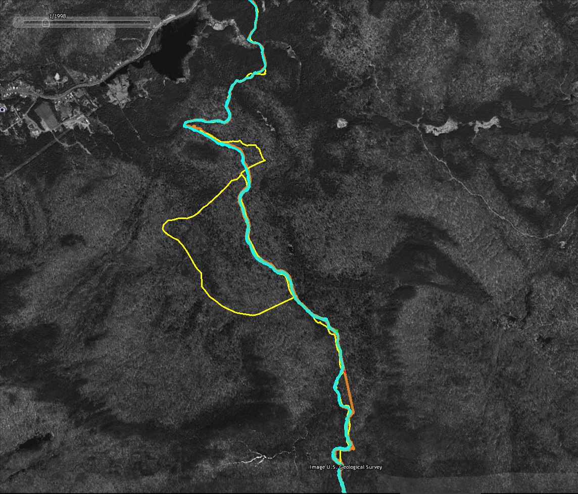
I've written about GPS accuracy in the past but nothing beats an example. The screen captures that follow (from Google Earth using historic imagery as the basemap) show how "accuracy" varies when using common GPS devices in the woods.
Legend:
  • Yellow Line: The trail as represented in the downloadable DEC Hiking Trails file. I don't know how DEC created the trails file but in many areas it shows only an approximation of route the trails actually take.
  • Cyan Line: The track captured by my Garmin GPSMap64 GPS Receiver. This was an out and back hike, so the two lines represent the trip up the mountain and return trip back down. Because I was snow shoeing in deep snow the two tracks should, in theory, overlap. I stayed in the trail I broke on the way up on the return trip.
  • Orange Line: The track captured using the GPS app on my phone. The two lines show the out and back routes as described above.
  • The Red Line is a high accuracy representation of the route. You can't see it in these images but the trail in the area shown follows an old woods road and it is possible to make out the route in the Google Earth imagery. The red line was traced from the image and should closely follow the actual route on the ground.
  • The horizontal green line; For scale, the green line represents a distance of 60 feet on the ground.


A section of the route overlaid with two sets of GPS tracks (the out and back tracks from two separate devices). The yellow line is less accurate representation from the DEC Trails download. The red line closely follows the actual route as traced from the image. 


Same as above with the less accurate tracks captured using the phone GPS hidden. The blue lines --tracks captured by a good consumer grade GPS unit-- vary by an average of 20 feet. The absolute variance from the traced representation of the trail (the red line) is also on average in 15-30 foot range. Larger variations might be the result of wandering off the trail at certain points.

For context, more of the followed route. The yellow "bulge" in the middle is a side trail off of the NLPT main route. The straight orange towards the bottom of the image is where the phone based GPS lost the GPS signal for a period of time. The straight line connects the points where the phone lost and later regained the signal.

Monday, October 24, 2016

Hitchen's Pond Overlook

Calling an Adirondack hiking route a "hidden gem" is more than a little cliched. There are so many gems to choose from. That said, Hitchen's Pond Overlook --and the trail that gets you there-- is a hidden gem. You reach the trail by following Route 412 to Horseshoe Lake (from Rte. 30, south of Tupper Lake). Drive all the way around Horseshoe Lake and eventually the (now gravel) road turns sharply to the left and crosses railroad tracks. From there it's just under a mile to an intersection where a gated side road appears on the left. There are no signs or trail register to indicate that it's the right spot but there's plenty of room to park.

Hitchen's Pond Bog

Another bog passed on the way to Lows Upper Dam and the overlook.

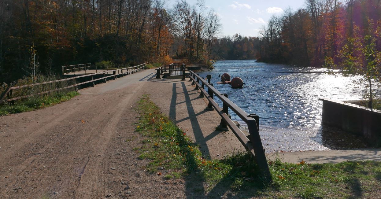
Pass the gate and you will soon see small signs indicating that you are in the forest preserve. Within a short distance you'll catch glimpses of Hitchen's Pond Bog, one of the largest in the Adirondacks. After roughly half a mile the route crosses a corner of the bog with extensive views. The road makes for easy walking and you'll pass several other places where bogs and swamps add interest to the 2.4 mile walk to Low's Upper Dam. The large concrete dam impounds the Bog River thereby turning what was once a 15 mile long series of lakes, ponds, bogs and swamps into the large body of water now known as Low's Lake.


Low's Upper Dam

The trail to the overlook leaves the dam site and ascends the obvious ridge to the north. It's a little over a mile to the open rock where the trail ends with spectacular views of the lake and bog dotted country around Hitchen's Pond. On a clear day several Adirondack ranges, including portions of the high peaks, can also be seen. I was lucky enough to visit the overlook at around 5:00 pm on a gorgeous late October day. While there the cold front that had been threatening all afternoon arrived from the west and the light breezes because a steady 25 mile per hour wind. Take a look at the video to see what I mean.


Looking southeast from the overlook

Looking east from the overlook. The center peak of the ridge of three distant summits is Kempshall Mountain near Long Lake.

Looking south from the overlook

Monday, October 17, 2016

Blind Mans Vly

This was my second attempt to reach Blind Mans Vly and this time I got there. My first try had been turned back by an unexepected late-spring snow storm (on May 15th) and high water in East Canada Creek. This time I had a mild mid-October day and low water.

East Canada Creek just below Big Alderbed Vly.
Blind Mans Vly is a small shallow pond just half a mile (as the crow flies) from Big Alderbed Vly. Big Alderbed can be reached via a snowmobile trail that leaves the Powley-Pisceco Road north of Stratford (2.7 miles). The trail to Big Alderbed tends to be wet but it is hiker friendly with the only possible challenge coming at the crossing of East Canada Creek just below the vly (easy at except at times of high water). Blind Mans Vly is just 100 feet higher than the trail end at Big Alderbed. It is, however, tucked in between two small ridges and I discovered that it's a lot easier if go around the end of the interveening ridge. I went over the ridge and learned that it has a couple of bands of small cliffs that are surprisingly rugged. Much easier to go around.

The route as recorded by GPS and overlaid on Google Earth.

Blind Mans Vly is an appealing destination but, even so, I don't often go back to places I've recently visited. There are so many new areas still left to explore. So the real reason for repeating this route lies in the trees themselves. The forests west of the Powley-Piseco Road, and the area around Blind Mans Vly in particular, are notable for the presence of old growth timber. Understanding and mapping the history of the Adirondack forest is my hobby so I wanted to take another look.

Happily, having returned and looked again, I've come away with new questions. Were these tracts logged? If cutting did take place when was it done and which species were taken? Three things stand out; the presence of large Red Spruce, the presence of very large Yellow Birch and what strikes me as an uncommon prevalence of Black Birch mixed in with the standard hardwood species. Spruce were the most sought after trees during the unregulared logging period of the late 19th and early 20th centuries. This route passes through scattered pockets of spruce some of which are 24 inches in diameter and greater. Spruce trees grow slowly so those are old trees. Also present are many very large Yellow Birch. A number of these trees are over 40 inches in diameter and a few elders push 48 inches. Like the spruce, Yellow Birch is a long-lived species so these are undoubedly old growth trees. As mentioned, there are also significant numbers of Black Birch mixed in. I don't recall having seen that species in such significant numbers elsewhere and I don't know what to make of that.

And old growth Yellow Birch with a diameter just under 48 inches. I didn't provide anything to show the scale so you'll have to take my word for it.
The perplexing part is that the Red Spruce and Yellow Birch are the only species present that appear to predate the logging period. In a virgin forest I would expect to see large Maples and other hardwoods as well. And I would definately expect to find large Hemlock. And it's not that these species are absent. Maple and Hemlock are both fairly common along the route but the largest specimens are around 24 inches for the Maples and slight larger for a few of the Hemlock. For those speices that means the trees are unlikly to be much over 100 years old.

Maybe the old growth Maples were taken by loggers looking for just speicific hardwood species. Based on what I know about logging practices in those days that would have been unusual. The lack of old Hemlock is easier to understand. Hemlock bark was the essential raw material of the tanning industry that flourished in the southern Adirondack region in the late 1800s. So it's easy to imagine that the old growth Hemlock might have been taken while other species were ignored.

It would also be easy to overthink this. It could easily be that the combination of land ownership, forest composition and topography simply made this area less attractive to loggers than other nearby places. The East Canada Creek West Branch is large enough to float logs but between Big Alderbed Vly and the confluence of the west and east branches at Powley (near the starting point for this route) the creek passes through several long flat stretches where even the spring flood might not have provided enough water to move logs downstream. These meadows are filled with grass and they look like hay fields ready for harvest. That also strikes me as unusual. I'll guess I'll have to go back again.

Along East Canada Creek below Big Alderbed Vly. The creek meanders through several very flat grass-filled meadows.


Very flat terrain. East Canada Creek is flowing through the middle of this sea of grasss. 

Big Alderbed Vly following an unusally dry summer. Quite different than the last time I was there with a heavy spring snow storm blowing through.


A glacial erratic close to the north end of Blind Mans Vly. Yes there is a tree growing on top of the rock.


The color was past peak but some bright spots remained.

Monday, October 3, 2016

Blueberry Mountain Parts Two and One

This was my second ramble to the vacinity of the top of Blueberry Mountain. This particular Blueberry Mountain is located just south of Kemshall Mountain; a mile from the east shore of Long Lake. I had previously bushwhacked up the mountain from a point on the Northville Lake Placid Trail about 3.5 miles north of the NLPT parking area on Tarbell Hill road. The route I took on that first trip was very steep and it passed through a dense swath of Spruce and Balsam. At the time I decided my route was ill chosen and in fact I came down the north side of the of the mountain where I stumbled on the old trail up Kempshall Mountain. Since then I've been back and followed the abandoned trail to the top of Kemshall. That route climbs to a saddle between Kempshall and Blueberry and I figured that the best route up Blueberry would be to follow the old trail to the saddle and then bushwhack to the top from there. This is indeed the easier way to go.

A low cloud cover limited views from near the summit of Blueberry Mountain.

But the main reason to hike Blueberry again was that my brother Mike was visiting from Colorado and we were looking for a good outing. Something close to town, of moderate length and hopefully with views. Blueberry normally has fantastic views and I figured it to be a 12 mile round trip with the last 1/2 mile a bushwhack up from the saddle. That seemed like the right mix so off we went.

And we did reach the top basically as planned. The bushwhacking stretch was a little harder than anticipated but 45 minutes after we left the old Kempshall trail in the saddle we came to a boulder with a small cairn on top of it. There didn't appear to be any more "up" anywhere around so we declared that point to be the summit. As for the view, the top of Blueberry is in the elevation zone where dense stands of Spruce and Balsam typically dominate. And the cover on summit of Blueberry varies between dense and very dense. However, I knew from my prior visit that open rock slabs exist on Blueberry with great views. Searching around on top we did find some rock outcropings that could have had good views. Unfortunately, as the day had progressed the thick overcast had lowered until visibilty from the top was on the order of a quarter mile. Basically we were staring off into the clouds.

Yup, still limited over on the other side of the summit area.
There it is, the view, looking southwest from one of the open areas near the summit of Blueberry Mountain. This shot is from my prior visit in July of 2014.

Still, I assured Mike that there were two large areas of open rock where good views would normally be found and that maybe we could sneak a view through the clouds from one of those areas. After half an hour of searching, beating through the thickets, I sensed that Mike was starting to doubt that these "open areas" even existed (Ok, it didn't require any great powers of perception, he readily pointed out that this was his theory). Eventually we paused for lunch at a place near where we had first reached the top.

Screen capture from Google Earth showing our route. The orange line is the GPS track. The yellow line is the trail overlay from the New York State Dept. of Environmental Conservation trails map. This version (of the overlay) still shows the trail up Kempshall Mountain. That trail is officially abandoned and while still easy to follow it is not a marked trail.

A broader perspective on our route and the summit of Blueberry mountain. Kempshall is in the background.

Returning home the GPS track told the tale. We had circled around the summit of the mountain and the two large open areas (yes, they do exist) are slightly lower down; one on the west side and one on the east. We had come close to each one but had not gone far enough down the slopes to break out into the open. Oh well, there wouldn't have been views anyway. That is the story I'm sticking with. Now I'll just have to make the pleasent walk down the lake and up Blueberry again to see those great views. It could be worse.

Along the shore of Long Lake near the point where the abandoned Kempshall Moutain trail intersects with the NLPT. The lake is very low, even for this time of year (Oct. 1). The summer has been unusually dry and hot 
Long Lake from near place where the picture above was taken. The bushes in this photo are also in the previous picture. In that one seen from the side. A point was under water when this picture was taken in July of 2014.

Forest scene from along the NLPT along the way to Blueberry Mountain.
Another forest scene. From July 2014.

Near the top of Blueberry Mountain. Previous visitors had built chairs from which to watch the sunset (one might imagine).

Near the top of Blueberry Mountain. July 2014.

Near the top of Blueberry Mountain.

Lichen, near the top of Blueberry Mountain.