Showing posts with label Asiatic Bittersweet. Show all posts

Thursday, October 2, 2014

Moreau Lake State Park: A Little Known Gem

I've been fond of hiking for a long time and I've acquired more than a few trail guides along the way. Which has led me to wonder whether the authors of these guides ever regret giving the world directions to their favorite places (assuming that their favorite places are actually included in their books). It’s with this thought in mind that I start this post by saying that the hiking trails of Moreau Lake State Park are a hidden gem.

Moreau Lake State Park (MLSP) is well known to locals as a place for swimming and camping but I’d not given it much thought as a hiking destination. I knew that the park had been expanded in recent years, and a friend had mentioned that the trails were interesting, but it was canoeing on the Hudson River above the Spier Falls Dam that led to my "discovery". There are a series of dams on the Hudson between Corinth and Glens Falls and the reservoir behind the Spier Falls Dam is a favorite place for an afternoon outing. From the water you can’t help but notice the forested ridge rising above the east bank of the river. The ridge is is part of a range of Adirondack mountains known historically as the Palmertown Range. I finally got out for a solid hike in the park in late July (2014) and I've since been back a half dozen times.

You can start your outings in MLSP near the lake (there is an entrance fee for the picnicking and swimming area) but the trails accessible from Spier Falls Road provide a quieter (and free) place to start. There are three official trail-heads, and numerous bushwhacking options, but all options begin with a climb of 500-800 feet to the top of the ridge. The "ridge" is actually a small plateau roughly four miles long and a mile across (the entire park covers over 4000 acres). Once on top there are numerous trails to choose from; anything from a short loop taking in a couple of views (2-3 miles) to a grand tour covering 8 or more miles. Obtaining a map of the park trails is recommended. The trails are well marked but the intersections can be confusing and there are few signs to guide your way.
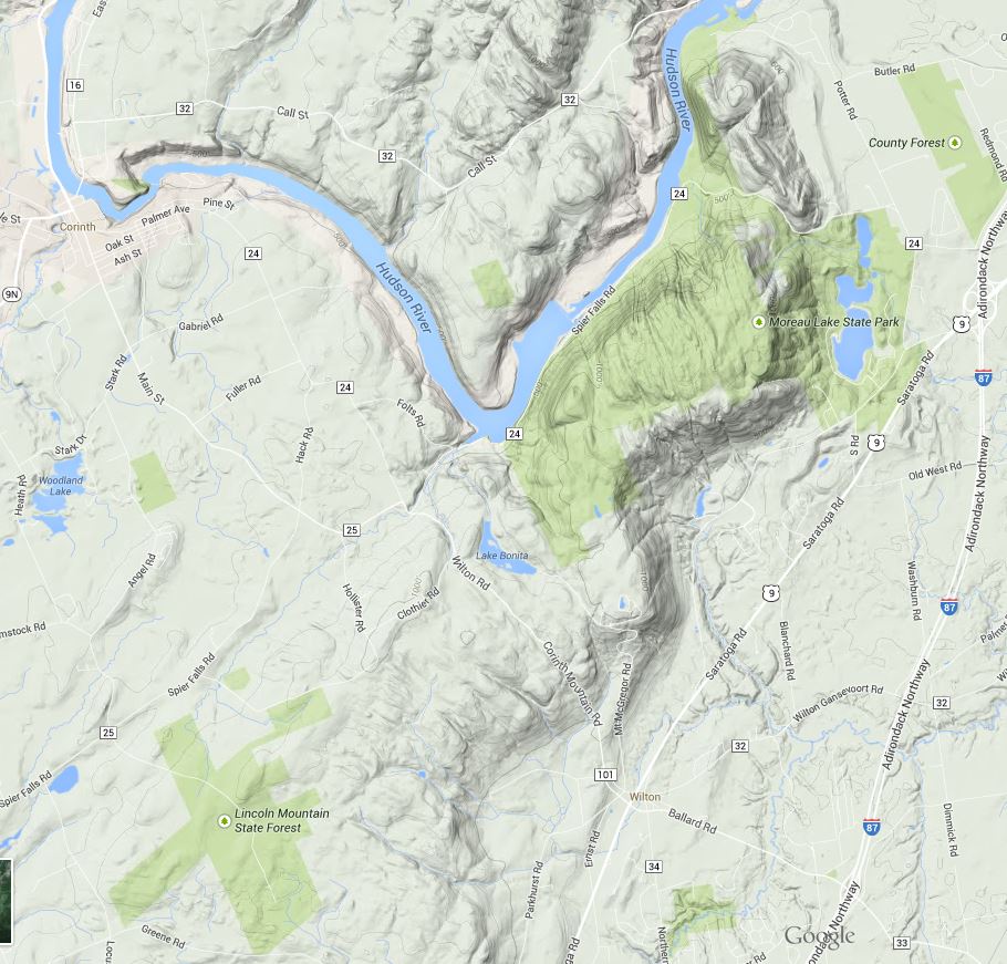
moreau_lake_topography.JPG
Image from Google Maps showing the location and terrain of the Park. The park includes significant areas northwest of the Hudson not represented in this map as public land (the light green shade) .
moreau_lake_trails.PNG
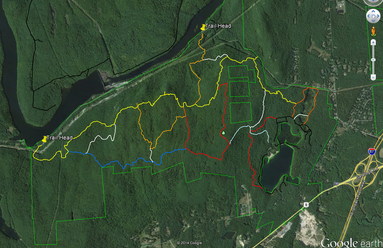
Image from Google Earth showing the trails
Some maps name this section of the ridge Grant Mountain but it would take some searching to find the summit. The ridge top area lies at an elevation of between 1000 and 1250 feet with numerous steep sided glacial cuts and small rocky ridges imparting an unexpected ruggedness to the terrain. Examination of a topographic map of the area shows that the Palmertown Range is part of the of the larger Adirondack uplift. Grant Mountain is defined by a glacial cirque and escarpment on the east side and by the gorge cut by the Hudson River on the west. You can see this clearly using the “terrain” (topographic) view in Google Maps (https://goo.gl/maps/AOaPa).

The map above (from Google Earth) shows the Moreau Lake State Park trail system with two of the west side trail-heads marked. As a point of reference, Northway (I-87) exit 17 is seen on the right side of the map. Spier Falls Road runs along the Hudson River between the two marked trail heads and a 3rd trail-head is found where the yellow trail intersects the green park boundary line in the upper right part of the image. Spier Falls Dam creates the prominent widening of Hudson in the center left of the image. The colored lines show most (but not all) of the trails in MLSP and you can download the trails file from the park website. The file is in the KML format that can be opened using Google Earth. To get some idea of the scale, from the trail-head marker on the left to the point where yellow joins orange on the right is about 4.5 miles.

There are several places along the yellow trail with good views of the Hudson River and the southeastern Adirondacks and an excellent view of Moreau Lake (and east toward Vermont) can be had at the point where the red trail joins the light blue trail. But the views are just icing for me; the ridge top area holds an intriguing and attractive landscape. The terrain is varied and it is overlaid with a matrix of past human activities and the effects of those activities. Much of the forest appears to be 100 year old (approximately) second growth but the effects of more recent logging or fire are seen in some areas. A few abandoned carriage roads can be found but I've seen no sign of pastures or structures.

The most common ecological communities of the ridge top area are the Appalachian Oak-Pine, Beech-Maple and Hemlock Northern Hardwood Forest types. At smaller scales perhaps a half-dozen additional community types present (see the notes at the end). Interesting, from an ecological perspective is that the central section is poorly drained with numerous small marshes and seasonal wet spots. These wet areas are interspersed with dry, rocky, ridges -with thin soil- where Chestnut Oaks are the dominant tree species. This combination is found around the edges of the Adirondacks uplands but it is uncommon in the interior of the range.

Over the coming weeks I'll add posts describing the natural and environmental history of this fascinating area but for now some photos will have to suffice.

Fungus seen along the trail. If anyone can ID this please leave a comment.

The Hudson just north of the Spier Falls Dam. The boat launch is located at roughly the lower left corner of the picture.

A small marsh.

Moreau Lake and the view looking east.

Looking northwest from a view point on the yellow trail.

Looking west across the southern Adirondacks; also from the yellow trail.

Spier Falls Dam on the Hudson seen from a view point on the yellow trail.

1.Ecological Communities of New York State (Edinger et al. 2014) - The definitive guide to ecological communities in New York State from the New York State Department of Environmental Conservation web site. http://www.dec.ny.gov/animals/97703.html

2. Moreau Lake State Park Master Plan Chapter Two The Moreau Lake State Park Master Plan (from the Office of Parks and Recreation) contains a detailed assessment of the the natural heritage of the park. The entire plan (comprised of several chapters) can be found on the park website.


Monday, April 7, 2014

Spring, Robins and Oriental Bittersweet

Got out into the forest yesterday (April 6) and the end of a long cold winter is finally here. I had not walked in the forest for a couple of months so I was out just to enjoy the "spring like" conditions (48f with a brisk breeze; snow and ice remaining where ever it has shelter from the sun). Happily, as often happens, I noticed two interesting things during this stroll.

The first was watching Robins feeding on the berries of Oriental Bittersweet. If you've read any of my other posts you know that Oriental Bittersweet has had visible effects on the forest in these here parts and during yesterday's walk I saw an effect I had not previously considered. As I walked I was checking birds to see what species were about on an early spring day and I notice that a group of American Robins were feeding on Oriental Bittersweet berries.

Robins' eating berries is hardly news. My Peterson Eastern Birds guide even notes this as a common "winter" behavior. But, the thing is, Robins were prominently present in Saratoga Springs throughout the winter this year and it was a very tough winter. I saw Robins near my house all winter long and, for much of the winter, a group of 10 or so roosted a large Yew bush just outside my back door. The bush had acquired a canopy of ice and snow which apparently provided some shelter from the wind and cold. I also saw Robins outside my office window (on the other side of town) throughout the winter; usually in a cluster of ornamental crab apple trees.

My Perterson Guides (one from the 50s and a 4th Edition published in 1980) both show Saratoga Springs as outside of the Robin winter range (though only by 100 miles or so). So the question is; does the presence of overwintering Robins represent an extension of their winter range or is it more a case the representation seen in these books being off by what at the scale of the maps is is small amount? The bonus question is, assuming that Robins are extending their winter range, what role are non-native plant species playing in this development? Oriental Bittersweet is present in significant quantities throughout the city as are other non-native trees and shrubs (ornamentals) that bear fruits and berries. Have these human alterations allowed the Robin to extend its' winter range by providing additional food sources? This is a specific example of the larger questions I have about the role humans are playing in altering ecological communities at regional scales.

Flooded hardwood forest area at the south end of the Hemlock Forest; April 6th, 2014

The second "interesting" thing I noted was related to my absolute favorite species present in the Hemlock Forest. As I walked into the woods I wondered if Deer Ticks (Black Legged Ticks) would be active at this point in early spring. I commonly take precautions against ticks such as spraying my pants with tick repellent but I left the house without thinking about ticks. This seemed safe if only because the grasses and plants where they tend to wait for potential meals are mostly still frozen or semi-frozen. However, habits being what they are I periodically checked my clothes for unwanted guests. Nearing the end of the walk I noticed a small black spot on my pant leg. Thinking that it was probably dirt I picked it off and lo and behold it started scurrying across my finger tip. Spring is really here. The Deer Ticks are on the prowl.


Sunday, December 8, 2013

Data: Bittersweet

You can't talk about invasive plant species in this part of New York State and not talk about Asiatic Bittersweet (AB). This vine is one of the most visible and damaging of the invasive species found in the Hemlock Forest. I know a little more about the specifics of this plant because about 10 years ago it appeared in my backyard. I've been battling it there ever since. I cut it off at the ground and I pull it out by the roots. I've fought AB to a draw in my yard but it is everywhere in the surrounding area; especially in a successional field near my house where it has pulled down several trees by the sheer weight of the vines. AB spreads both by the dispersal of seeds by birds (that eat the berries) and via rhizomes that spread out from every established vine. This plant is not going away anytime soon.

Image One: A dense cluster of Asiatic Bittersweet vines in the Hemlock Forest.

Asiatic Bittersweet is not a shy plant and even in a dense forest spotting the vine is easy. It wraps itself tightly around the trunks of trunks of trees and it will bridge from tree to tree in the canopy. But it is in the late fall and winter that AB really stands out. Mature plants produce large quantities of orange-red berries with yellow sheaths that are quite distinctive. The only plant you might confuse it with is its native cousin, American Bittersweet. Asiatic Bittersweet hybridizes with the native variety and by all accounts the hybrid is quickly replacing the native version everywhere that both species are present. Unfortunately, the hybrids appear to take on the negative characteristics of the invader. Namely, it's ability to produce a mass of vines that tend to strangle whatever it gets a hold of. The native variety is certainly not extinct, so before you take actions to control this plant be sure you know which one you are looking at. The plants are very similar in appearance with one easily spotted distinction. When berries are present, if the berries are found all along the vine it is Asiatic Bittersweet. The berries of the native variety appear only at the very ends of each vine.

AB will be one of the plants I focus on in studying the invasive species present in the Hemlock Forest. The general questions I've discussed in other posts certainly apply and, in the case of AB, there is the additional issue of why the non-native variety is so much more destructive than the native species. In the Hemlock Forest AB is found pretty much everywhere there is an opening in the canopy. There are several old fields in various stages of succession in the forest and AB is present in all of them. It is almost certainly present in other places in the forest as well and one of my first goals will be to map the full extent of its' presence. That data can be used in the future to learn more about how AB disperses. AB can also be used to study how community assemblages are changed by a well established and aggressive invasive species.

Map One: The purple polygons show areas where Asiatic Bittersweet is present in significant quantities. This highly aggressive vine is probably found in other parts of the forest but I have not yet specifically mapped its' presence.


References and Resources:
Asiatic Bittersweet (Wikipedia)
Mistaken Identity: Invasive Plants and their Native Look-alikes