Overall, the winter of 2016-2017 was mild. Storms in March and April moved the snowfall total towards the average but temperatures for the season were well above normal (1). So entering the last week of April spring was in full control of the southern Adirondacks. Over the past few years I've come to see early spring as a good hiking season with one potential drawback, mud. During the winter months moisture in the soil freezes and it takes a while when spring arrives for this frozen layer to thaw. Rain and snow melt can then saturate the ground above the frozen layer and creates the muddy mire we associate with "mud season". It's not pleasant to hike through and many unpaved roads are closed until May to prevent damage. Even so, if you exercise a little judgment you can get out during mud season in most areas without damaging the trails. Plus, if your timing is good, the Adirondack Protection Force (mosquitoes, black flies, and deer flies) will waiting for warmer days to come to launch their assaults on those who venture out.
Brand new signs clarify the options at the junction of the Godfrey Road access trail and the NLPT.
My day started on the trail that leads from Godfrey Road to the Northville Lake Placid Trail (NLPT). At the trail junction just past the bridge over West Stony Creek I turned towards Woods Lake and the Benson Road. I had walked parts of this section previously. From this end on my way to Three Ponds Mountain and on a different day from the Woods Lake end turning back at Abner Brook. This left a two mile section along Abner Brook that I had not visited and still wanted to see. I planned to hike to the NLPT bridge over Abner Brook and then leave the trail and bushwhack over a ridge and into the valley of Notch Brook. A 19th century road passes up that valley and through a low pass immortalized on USGS topographic maps as "the notch". The old road would provide a route back to the NLPT and back to the car and, if time allowed, I wanted see what the "notch" looks like.
The red line is the NLPT section from Benson Road near Woods Lake (lower right) to the West Stony Creek North Branch Junction (at the sign post pictured above). The dark line is the route described in the story.
The day went mostly as planned though I didn't go as far up the ridge as I thought I might. This was my first real outing of the season and the effects of winter were weighing on me. As it was, the route covered 10 miles with bushwhacking and route finding. A pretty good stretch of the legs.
Abandoned beaver ponds transition to swampy meadows. Beaver are a keystone species in the Adirondacks shaping the landscape and supporting ecological variety.
Abner Brook just below the bridge on the NLPT. Abner Brook cuts a meandering path through a relatively flat valley creating ideal habitat for Beaver.
This was not one of those hikes where a single place stands out as the "best" part of the day. It was, however, a warm, cloudless early-spring day with dry trails and no bugs. That combination is hard to beat. But, a few things are worth noting:
The Abner Brook Valley contains an extensive network of beaver meadows, swamps and ponds. This valley is a great place to see the full range of effects this creature has on the Adirondack landscape.
A cluster of large, healthy-looking, Beech trees on the Wallface Mountain ridge
A ravine with interesting talus slopes and a possible micro-climate
The tranquil beauty of the upper Notch Brook Valley
A bit of snow remained at the bottom of the small ravine I explored while crossing the Wallface ridge. The steep slope on the southern side of the ravine prevents direct sun from reaching the slope. Creating an environment that will on average remain several degrees cooler than surrounding terrain.
The ravine was perhaps most interesting. One hundred feet deep at most this glacial gouge is barely detectable on large scale topographic maps but quite striking as seen from the rim. The ravine crosses the ridge with an east-west orientation and the south-side bank is steep with a small cliff band at the top. Over the millennia since the last glaciation rocks and small boulders have fallen from the cliff band and created a talus slope. The orientation of the ravine means that even in high summer the sun will not reach the bottom until afternoon and further up the slope there are areas that probably never see direct sunlight. Winter comes early and spring arrives late in this micro-valley. And the talus that makes it rough going for hikers also limits the advance of soil and trees. magnifying the micro-climate effect. This is the kind of place where a botanist might look for uncommon plants.
Notch Brook. Late afternoon. April 24th, 2017. A perfect place for a short nap.
The Benson to Wells road crossed Notch Brook at this point and the abandoned road is easily distinguishable on the far side. Below this crossing (towards Benson) the road is still easy to follow though extensive blowdown results in many detours. Above the crossing the blowdown is even heavier and in places the old route becomes indistinct. I still didn't make it to the height of land in the "notch". Maybe next time.
The Adirondack wilderness is wild but it is not untracked. A cook stove near the abandoned Benson-Wells Road.
Tree barnacles. Some kind of fungus seen on a downed tree at 1800 feet. Over a small area all the downed trees were covered with this growth. It may be common but I don't recall having seen it elsewhere. Maybe I just haven't noticed.
Notes
1) Heating Degree Days for Glens Falls New York. In 2017 March was slightly colder than average but January and February were well below the 10 year average.
Hikers planning to walk the Northville Lake Placid Trail (NLTP) from south to north have long faced a bit of dilemma in deciding where to start. From the official trailhead in the village of Northville the first twelve miles of the route were along paved roads and you would have walked 14 miles, at a minimum, to reach a place where you could camp. For that reason, many thru hikers started their journey at the so called "Upper Benson" trailhead on Godfrey road.
Two new sections of trail change that calculation completely. A thru hiker might still chose to start at Godfrey road but, if you do, you'll miss two compelling new segments of the trail. The first section runs from Collins Gifford Valley Road near Northville to the Benson Road; covering a distance of 8.6 miles. The second section links the Benson Road crossing with the original route at the place where the original route crossed the West Stony Creek North Branch (the bridge about 2 miles from Godfrey Road parking area). This second section covers seven miles and both sections together add 15 miles of new trail to the the NLTP.
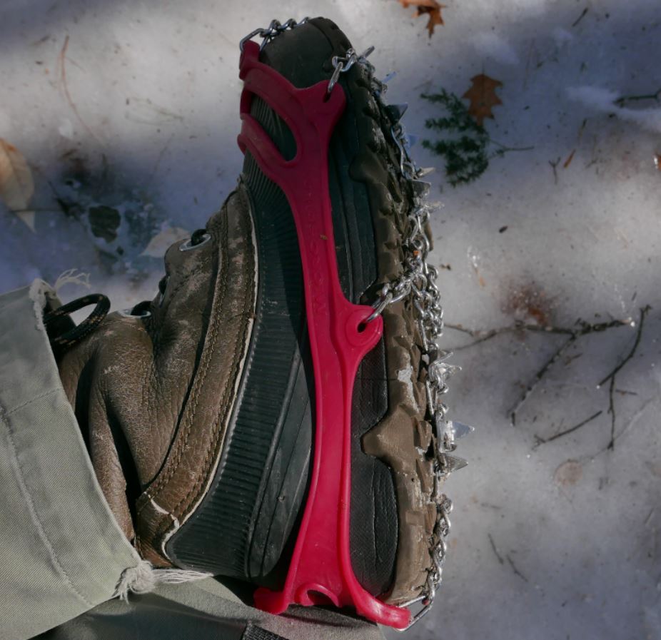
I recently walked significant portions of both of the new sections on successive weekends at the end of February and beginning of March 2016. Both trips, were made possible by the use of micro-spike "boot chains". In both cases the trails were extremely icy and neither excursion would have been possible without the micro-spikes (Images 1 and 2).
Image One
Image Two: Unusually icy conditions prevail in early spring 2016. Walking these trails would not have been practical without the use of micro-spikes.
The first of these two outings covered a portion of the the new trail that runs from the Benson Road to West Stony Creek North Branch (north of the Benson Road). The following weekend I walked the section starting at the brand new trailhead on Collins-Gifford Valley Road to the crossing of the West Stony Creek. Both hikes covered about ten miles for the round trip.
Notices at the trail registers warn that though a bridge is planned, currently there is no bridge over West Stony Creek. This is important for anyone planning to start a NLTP journey at the Gifford Valley trailhead because West Stony Creek is a significant stream. The creek can easily be forded at times of low water, but in the spring, or after heavy rains, it could present an impassable barrier.
Image Three: The only other hiker I saw on two full days of hiking is seen above on the far side of Stony Creek. He evidently hiked from the Benson road south to the creek crossing.
Not surprisingly, on the day I was there, March 6, 2016, fording the stream would have been a risky undertaking. West Stony Creek at the place where the trail crosses is wide and in early spring it carries a significant volume of water. The creek does look to be shallow, probably no more than knee deep, but with lots of ice and freezing water to contend with I can't imagine a casual hiker trying to cross at this time of year. The crossing will look completely different in six weeks and by mid-summer it might be possible cross without getting your feet wet. But without a bridge you need to factor the creek into any plan to pass thru this section. I shot a couple of short videos to illustrate.
I'm going to come back to these two outings in future posts, but for now I'll let a quick summary and some photos do the talking. Setting aside the value that these re-routes provide by finishing the long story of the NLTP, the first section, from the Collins Gifford Valley Road to the West Stony Creek crossing is a great new hiking route all on its' own. After climbing steadily for the first mile this section of trail enters a rapidly maturing oak forest that is notably different from forests along most of the NLTP. Then, at just under two miles you reach Mud Pond. The setting for the pond is attractive and open rock is visible on the ridge line northeast of the pond. The ridge appears to be easy to reach and probably has some nice views. I'm planning to return at some point to see for myself.
Image Four: Mud Pond in late winter splendor.
Past the pond the trail passes through a complex of small ridges coming down from the surrounding mountains and it crosses two stream carved valleys. Along the way the forest transitions to a more typical mix of Hemlock and northern hardwoods. This is a very attractive section of trail and the second major stream crossing, about a mile from Stony Creek, is at the head of a small gorge that also looks to be well worth a visit with time to explore.
Image Five: Details seen along the trail.
At just under five miles the trail reaches the ford of West Stony Creek. The area of the crossing, on the south side of the creek, looks to have a number of attractive potential camping spots and I suspect that this will become a well used destination.
All in all, the five mile stretch south of Stony Creek is a lovely hike on its' own terms and I have no doubt that I will return soon. When it is possible to cross it's 2.8 miles from the north bank of the creek to the Benson Road. Walking that section of trail is near the top of my list of possible future outings.
The second of my two recent hikes started at the Benson Road and covered the first five miles of the seven mile route to where the new trail joins the prior route of the NLTP. That outing was similar to the one I've just described with very ice trail conditions defining the day. The highlights of this section include the passage of Woods Lake; a long-time favorite local destination. Along the mile long shore of the lake the trail traverses some splendidly rugged terrain in crossing a ridge of Little Cat Head mountain. Little Cat Head reaches barely 2000 feet in elevation but it's an intriguing mountain with potential viewpoints. From the ridge to the point where I turned around the trail passes through mostly young second growth forests with sections of more mature Hemlocks along a couple of small ridges. I suspect that the section from where I turned back to the place where the new trail joins the old route is more interesting, but I had to leave that for another day. The Ten mile round trip --crunching along over icy ground the whole way-- is my limit for this time of year.
Image Six: Glare ice along the shore of Woods Lake. Heavy rains in the prior week followed by a temperature plunge to near zero created hard ice conditions.