Showing posts with label Palmertown Range. Show all posts

Saturday, March 11, 2017

Moreau Lake State Park: Wondrous Lake Bonita Trails

It was just 24 months ago that 750 acres formerly held by the now closed Mt. McGregor Correctional Facility were formally added to Moreau Lake State Park. Since then a new parking area for hikers and three new trails have been built. That's a pretty good pace for these sorts of things but what makes this a truly impressive effort is that these new trails are really well thought out. Moreau Lake State Park now offers hikes ranging from a couple of miles to a "grand loop" covering nearly 15 miles without any retracing of steps (you can bet an account of that walk will appear on this blog in the future). My most recent outing, covering nine miles, took me past two attractive lakes, over ledges and past cascades and through an attractive and varied forests. There are good view along the way of the Hudson River and the southern Adirondacks.

An overview of the Moreau Lake State Park trail system. The heavy blue line, starting at the bottom left, is the route described in this post. The other colored lines seen on the map represent other trails in the park. For scale, the route represented by the heavy blue line covers a distance of just over nine miles. The two sections closest to the bottom of the image are new trails added as part of the Lake Bonita expansion.
The newest trail leaves the Lake Bonita Loop Trail near the spillway at the north end of the lake. From there it's about 1.5 miles to a to a junction with the West Ridge Trail. At the time of this writing that junction is unmarked but the trail itself is well marked (parking is on the Corinth-Wilton Mountain Road).

The Western Ridge Trail is one of the primary access trails that lead up onto the Palmertown ridge and the Park's main trail system. The Palmertown Ridge is interesting from both geological and ecological perspectives and evidence of the last glacial period lies heavily on this landscape. It is generally believed that the ice sheets of that last glacial period retreated from this area between twelve and fifteen thousand years ago with mountain glaciers persisting into the more recent end of that range. That's a long time by human standards but not even the blink of an eye in terms of geologic time. Walking the trails on the Palmertown ridge always reminds me of this. There are many places where soil lies just a few inches thick on top of deeply scarred bedrock.

A rock outcropping along the new trail from Lake Bonita to the Western Ridge Trail.
The geology of the Palmertown ridge strikes me as being somehow different from similar landscapes in the southern Adirondacks. For example, the ridge crossed in the first couple miles of the Northville to Benson section of the Northville-Lake Placid Trail has some characteristics in common with the Palmertown Ridge. The Northville ridge is a little higher but ecologically similar; an Oak-Hemlock forest. But the landscape has a different feel. Could it be the distinction between being part of the Canadian Shield (the primary geologic formation of the Adirondacks) as opposed to rock that has been pressed up against the shield. I'm imagining that as a possibility for the Palmertown Ridge. The most likely explanation is that this is my imagination run wild. Perhaps someone with more knowledge of the geology of the region will let me know.

In any case, the terrain encountered on the Palmertown ridge is unexpectedly rugged and, according to my GPS, the total elevation gain for the route I walked was 2200 feet. There's just a single significant climb so nearly all of that elevation gain comes from the relentless ups and downs you encounter along the way.

The shore line of Lake Anne. This small, shallow, lake is ringed by an ecologically interesting marshy shoreline. 
One point of specific interest for me was a stand of spruce on the northwest shore of Lake Bonita. I had noticed the trees on my previous visit. But that was a day of our only major snow fall of the year and with darkness approaching I took no time to investigate. Still, I did notice two things:
  1. The trees were some kind of Spruce (I was not sure of what variety) 
  2. The trees looked out of place
Taking a closer look under benign conditions confirmed both points. My first impression had been that this was a stand of Norway Spruce; a widely planted import to the Adirondacks. When Norway Spruce grow in the open --as the do in various places in Saratoga Spa State Park-- they exhibit a distinctive branching pattern that makes them especially easy to identify. However, when growing close together under constrained conditions Norway Spruce can look a lot like other Spruce varieties that are native to this region. However, there is one identifying characteristic that trumps all others. Norway Spruce have long cones that are much larger than any other spruce from around these parts. These trees are Norway Spruce.

A lovely cascade crossed by the new trail section that runs from Lake Bonita to the Western Ridge Trail.

From the first overlook on the Western Ridge Trail. This popular destination is barely a mile from the parking area on Spier Falls Road. It's a bit more than 2.5 miles from the new parking area on Corinth Wilton Mountain Road. The view is of the Spier Falls reservoir on the Hudson River and the Southern Adirondacks beyond.


Lake Anne. Late Winter.

This open glade on the ridge line near the Western Ridge trail was probably open meadow just a few decades ago. The trees are Chestnut Oak. A common species on this section of the Palmertown ridge. This species somehow favors the edges of steep ridges. I'd love to more about the history of the forest on this ridge.   


Monday, June 6, 2016

New Trails at Lake Bonita, Moreau Lake State Park

In many parts of the U.S., Moreau Lake State Park would be a premier destination for hikers (those of us who live near the Adirondacks are totally spoiled). The park contains an extensive network of trails that pass over a varied and surprisingly rugged terrain. There are options for everything from short walks to ten mile mountain grinders. And those options just got better; much better. Two new trails have been built that integrate the 800 acres transferred to the park following the closing of the Mt. McGregor Correctional Facility and these new routes are particularly appealing.

Overview map of the new trails. from the parking area on Wilton Mountain Road it's 1.5 miles to Lake Anne. From there another mile of walking takes you to the main park trail system at junction 3. 

The new routes include a well designed trail that circles Lake Bonita --a lovely and distinctive small lake that was previously inaccessible to the public-- and a connection from the new trailhead on Wilton Mountain Road to the parks' existing trail system at Lake Anne. You can find the details of what is planned in the Office of Parks, Recreation & Historic Preservation (OPRHP) addendum the Moreau Lake State Park Master Plan. I'll probably have more to say about the newly added areas in the future but, for now, a few photos will have to suffice.


Lake Bonita from one of the spur trails that provide access to the waters edge. The shoreline of Lake Bonita is mostly undisturbed and OPRHP states that the lake is free of aquatic invasives; a rarity these days. The master plan details the agency's intent to protect these attributes of the lake. Boats of any kind are prohibited and no live baits are allowed for fishing.

Lake Anne: This lovely small "bog lake" boast floating bog mats that are uncommon this far south. No fishing is allowed in Lake Anne and, given that the lake is shallow and has a measured pH of 4.3, it's doubtful that any fish could survive in its' waters. 

Extensive swamps surround Lake Anne. If you like swamps as both I and biting insects do, these are wondrous places. 

The connection from Lake Anne to the parks existing trail system opens the potential for long loop hikes along Palmertown ridge. The southern Adirondacks from one of the many viewpoints along the West Ridge Trail.

Looping back over the East Ridge trail you'll pass through some of the most rugged and wildest sections of the park.

Back at Lake Anne. There is a pretty decent lean-to near Lake Anne. The spot is attractive and the parks' plans call for allowing backcountry camping at this site. You would probably not want to do that in June however. Just trust me on that point. 


Lake Bonita

Lake Bonita

Lake Bonita from the dam.


Saturday, October 18, 2014

Moreau Lake - East of the Hudson -StoneWall Trail

The Hudson River splits Moreau Lake State Park (MLSP) into two sections. The main body of the park --where Moreau Lake is located-- is west of the Hudson River. However, a good sized chunk of park lies east of the river and coming from Saratoga Springs you must cross the Hudson to get there. Confusing the issue is that the Hudson makes a 90 degree turn and flows northeast through the park. So a hiker viewing the Hudson from the Palmertown Ridge is looking west toward the section of the park that is east of the river.

Moreau Lake State Park; The eastern section is on the left in this image of the park trail map.
To reach this eastern section of the park from Saratoga Springs take route 9N to Corinth. Cross the river and drive north for a half mile to the intersection with Call Street.  Turn right onto Call Street. About three miles from that intersection you'll see Hawk Road on the right (one sign says Hawk Street but it is Hawk Road). The first half mile of Hawk Road is paved but you'll quickly reach a steel gate where a sign reads; "Trailhead Parking Straight Ahead". From there it's about a mile on a one lane dirt road to the large parking area. As of October 2014 the road was passable for normal passenger cars with just a couple of rough spots.

The Stonewall trail --with Blue Markers-- leaves the west side of the parking lot (on your right as you drive into the lot). A second blue marked trail leaves the lot on the opposite northeast side. That trail is not seen on park maps that I have but it's a nice addition to the trail system. It makes possible a very pleasant loop hike of about 2.5 miles. The far point of the loop is near the Hudson at a spot where some 19th century building foundations remain. Making the "loop" is a bit confusing because, as mentioned, not all of the trails appear on the current trail maps. Even so, it's easy country to navigate and the continuation of Hawk Road (abandoned) crosses the trail at a couple of points making it possible to return to the parking area by that route.

Through the trees - the Spier Falls reservoir (Hudson River) 
This "Hawk Road Trail" (a name I just made up) also reaches the Hudson; but at a point further downstream just above the Spier Falls dam. From there the trail/road continues to the power line right-of-way leaving the power station at Spier Falls. The trail runs along the right-of-way as part of the canoe portage route around the Spier Falls dam. Canoeists approaching the dam from above leave the water and climb up to the road, follow a short stretch to Hawk Road to the right of way, and return to the water walking downhill under the power line. At that point you are on the upper section of a second reservoir backed up behind the Sherman Island dam about 3 miles further downstream. The hiking trail continues along the east bank of this reservoir for a couple more miles, but the transition between the two sections is heavily overgrown and serious tick precautions will be needed to get through unscathed.

Also worth mentioning is that this entire area is open to hunting and I ran into two hunters on my recent outing there. They politely handled their guns in a way that was safety aware but you should wear bright colors if you hike during hunting season.

As with the better known trails on the west side of the river, these trails offer a wealth of natural and human history to consider as you walk. I got a clear look at a male Red Bellied Woodpecker (Melanerpes carolinus). This species is distinctive and common in many eastern forests, but MLSP is a bit north of its' historic range. Which begs the question of whether this species is expanding its' range northward. And if so, why? Birds are able to respond to changing environmental conditions at a faster rate than many animals and plants (flying comes in real handy). So shifts in bird ranges can serve as an early indicator of changing ecological conditions. If the normal range of the Red Bellied Woodpecker is shifting northward it could be in response to a warming climate. But to make that assertion we need to know the natural history of this species for this area. Has the Red Bellied Woodpecker been present here in the past? If not, when did it arrive and what environmental/ecological changes make the area attractive now?

A less positive indicator of changing environmental conditions is seen in the extensive infestations of Asiatic Bittersweet (AB) along the section of Hawk Road that runs above Spier Falls dam. That AB is present here is hardly surprising. I had previously spotted AB from my canoe; at a place along the river/reservoir bank just below this section of trail. This area has been extensively altered by human activity and once it is present AB thrives where people disturb the forest and create forest edges. AB is common along a half mile stretch of the old road above the dam but I did not spot in the wilder forest areas. It would be interesting to survey the surrounding forest to determine the extent to which it has spread.
Asiatic Bittersweet along the (abandoned) section of Hawk Road near Spier Falls Dam.
Asiatic Bittersweet grows in dense stands that crowd out other vegetation and its' bulk can pull down trees. There is a similar native species; American Bittersweet. The two are easy to tell apart in the fall when the berries are present. If the berries grow all along a stem, it is the Asiatic variety. American Bittersweet has berries only at the ends of stems. Complicating matters is that the two varieties hybridize easily.
To round out my recent day of hiking I took a bush-whacking side excursion from the Hawk Road parking area down to the point where Bennie Brook flows into the Hudson (about 3/4 of a mile). Two things stand out from this little adventure. First, don't try to walk along the edge of the reservoir. It is really tough going and the dreaded deer (black legged) ticks --that carry Lyme disease-- are definitely present. The second point is that I did find something interesting along way; a very large White Oak, diameter 47 inches at chest height. This is probably the largest tree (by this measure) that I've seen anywhere in Moreau Lake State Park. And, because White Oaks are long lived, it could be the oldest as well. White Oaks can live to be 300+ years old and I'd love to know if this tree is really old, having somehow escaped logging, fires and other mishaps. Or is it a younger tree, maybe in the 150 year range, that just happened to grow under particularly favorable conditions. So many questions so little time.


Thursday, October 2, 2014

Moreau Lake State Park: A Little Known Gem

I've been fond of hiking for a long time and I've acquired more than a few trail guides along the way. Which has led me to wonder whether the authors of these guides ever regret giving the world directions to their favorite places (assuming that their favorite places are actually included in their books). It’s with this thought in mind that I start this post by saying that the hiking trails of Moreau Lake State Park are a hidden gem.

Moreau Lake State Park (MLSP) is well known to locals as a place for swimming and camping but I’d not given it much thought as a hiking destination. I knew that the park had been expanded in recent years, and a friend had mentioned that the trails were interesting, but it was canoeing on the Hudson River above the Spier Falls Dam that led to my "discovery". There are a series of dams on the Hudson between Corinth and Glens Falls and the reservoir behind the Spier Falls Dam is a favorite place for an afternoon outing. From the water you can’t help but notice the forested ridge rising above the east bank of the river. The ridge is is part of a range of Adirondack mountains known historically as the Palmertown Range. I finally got out for a solid hike in the park in late July (2014) and I've since been back a half dozen times.

You can start your outings in MLSP near the lake (there is an entrance fee for the picnicking and swimming area) but the trails accessible from Spier Falls Road provide a quieter (and free) place to start. There are three official trail-heads, and numerous bushwhacking options, but all options begin with a climb of 500-800 feet to the top of the ridge. The "ridge" is actually a small plateau roughly four miles long and a mile across (the entire park covers over 4000 acres). Once on top there are numerous trails to choose from; anything from a short loop taking in a couple of views (2-3 miles) to a grand tour covering 8 or more miles. Obtaining a map of the park trails is recommended. The trails are well marked but the intersections can be confusing and there are few signs to guide your way.

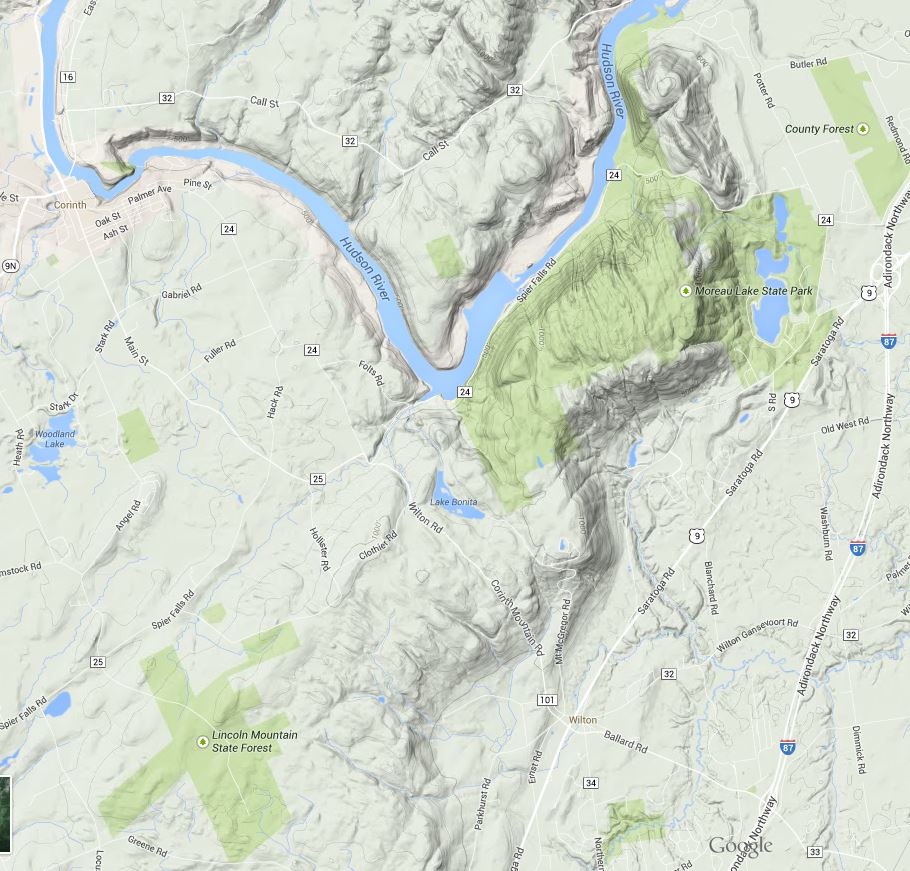
moreau_lake_topography.JPG
Image from Google Maps showing the location and terrain of the Park. The park includes significant areas northwest of the Hudson not represented in this map as public land (the light green shade) .
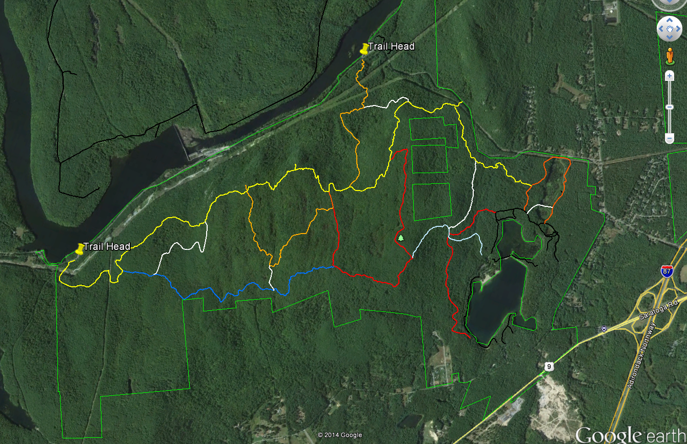
moreau_lake_trails.PNG
Image from Google Earth showing the trails
Some maps name this section of the ridge Grant Mountain but it would take some searching to find the summit. The ridge top area lies at an elevation of between 1000 and 1250 feet with numerous steep sided glacial cuts and small rocky ridges imparting an unexpected ruggedness to the terrain. Examination of a topographic map of the area shows that the Palmertown Range is part of the of the larger Adirondack uplift. Grant Mountain is defined by a glacial cirque and escarpment on the east side and by the gorge cut by the Hudson River on the west. You can see this clearly using the “terrain” (topographic) view in Google Maps (https://goo.gl/maps/AOaPa).

The map above (from Google Earth) shows the Moreau Lake State Park trail system with two of the west side trail-heads marked. As a point of reference, Northway (I-87) exit 17 is seen on the right side of the map. Spier Falls Road runs along the Hudson River between the two marked trail heads and a 3rd trail-head is found where the yellow trail intersects the green park boundary line in the upper right part of the image. Spier Falls Dam creates the prominent widening of Hudson in the center left of the image. The colored lines show most (but not all) of the trails in MLSP and you can download the trails file from the park website. The file is in the KML format that can be opened using Google Earth. To get some idea of the scale, from the trail-head marker on the left to the point where yellow joins orange on the right is about 4.5 miles.

There are several places along the yellow trail with good views of the Hudson River and the southeastern Adirondacks and an excellent view of Moreau Lake (and east toward Vermont) can be had at the point where the red trail joins the light blue trail. But the views are just icing for me; the ridge top area holds an intriguing and attractive landscape. The terrain is varied and it is overlaid with a matrix of past human activities and the effects of those activities. Much of the forest appears to be 100 year old (approximately) second growth but the effects of more recent logging or fire are seen in some areas. A few abandoned carriage roads can be found but I've seen no sign of pastures or structures.

The most common ecological communities of the ridge top area are the Appalachian Oak-Pine, Beech-Maple and Hemlock Northern Hardwood Forest types. At smaller scales perhaps a half-dozen additional community types present (see the notes at the end). Interesting, from an ecological perspective is that the central section is poorly drained with numerous small marshes and seasonal wet spots. These wet areas are interspersed with dry, rocky, ridges -with thin soil- where Chestnut Oaks are the dominant tree species. This combination is found around the edges of the Adirondacks uplands but it is uncommon in the interior of the range.

Over the coming weeks I'll add posts describing the natural and environmental history of this fascinating area but for now some photos will have to suffice.

Fungus seen along the trail. If anyone can ID this please leave a comment.

The Hudson just north of the Spier Falls Dam. The boat launch is located at roughly the lower left corner of the picture.

A small marsh.

Moreau Lake and the view looking east.

Looking northwest from a view point on the yellow trail.

Looking west across the southern Adirondacks; also from the yellow trail.

Spier Falls Dam on the Hudson seen from a view point on the yellow trail.

1.Ecological Communities of New York State (Edinger et al. 2014) - The definitive guide to ecological communities in New York State from the New York State Department of Environmental Conservation web site. http://www.dec.ny.gov/animals/97703.html

2. Moreau Lake State Park Master Plan Chapter Two The Moreau Lake State Park Master Plan (from the Office of Parks and Recreation) contains a detailed assessment of the the natural heritage of the park. The entire plan (comprised of several chapters) can be found on the park website.