Northville Lake Placid Trail: To the High Point
GPS Accuracy: This is what I've been talking about
Moreau Lake State Park: Heavy Snow
I have not been posting much recently because I have not been able to get out but on successive January weekends I got away for quick jaunts to visit a couple of favorite haunts. The first outing was to Moreau Lake State Park on a day when over a foot of snow fell. Over the six hours I was on the trail eight to ten inches of snow fell and by late afternoon tracks I had made in fresh snow in the morning had vanished.
Looking out from the lean-to at Lake Anne. For a time the snow was falling at a rate that accumulates several inches per hour. You might think that the video has been speed up in some way. It has not.
 |
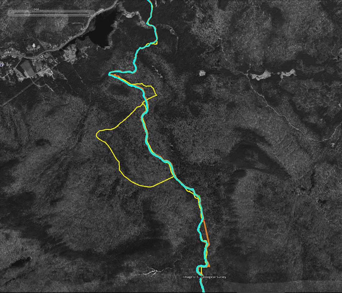
| The route. Note the red line leaving Lake Bonita. There looks to be a new marked trail going off in that direction. Also, my route does not follow the actual trail in several places. I tend to wander around investigating areas that catch my eye. The marked trail is easy to follow. |
It appears that the new parking area on Corinth Mountain Road will be kept plowed and open in the winter and that provides convenient access to new trails in the southern part of Moreau Lake State Park. I followed one those new trails to Lake Anne. From there a previously existing trail joins up with the Park's main trail system at junction S9 (if you are using the Park's official trail map).
The trail to Lake Anne (opened in the summer of 2016) passes through lands added to the park following the closing of the Mount MacGregor Correctional Facility. Intriguingly, on my way back to the car I followed the loop trail around Lake Bonita and it looks like another new trail has been added leaving the northern end of Lake Bonita next the spillway. If it goes where I think it might go it could make for a nice loop hike connecting with other trails that can be reached from Spier Falls Road. I'm planning to get back soon to take a look.
 |
| A Hemlock glade in winter. Snow fell heavily throughout the day. |
 |
| Lake Bonita from near the trail that circles the lake. This is from the southern end of the lake looking north. |
 |
| Lake Bonita again. This time from the far shore looking roughly from the east to the west. |
Northville-Lake Placid Trail to the NLPT High Point
My second outing was on the Northville-Lake Placid Trail south from the Rte. 28n junction just east of Long Lake village. This trail head is less than a mile from a family home in Long Lake and I've walked this route many times. However, this outing was different. A series of storms over the previous two weeks had dropped three feet of snow which was then softened up by two days of unusual warmth (60+ in Long Lake in February? That can't be right). Higher up the snow was even deeper; three to five feet depending on the slope and the drifts.
Video from near the place where I turned back. I didn't actually make it to the highest point on the ridge turning back a quarter mile or so short of the height of land. I had passed my turn back time and the going in very deep, soft, snow was sloooow to say the least So following a quick lunch I headed back down.
The trail was partially broken to the point where the Three Brooks Ski trail joins the NLPT but past that junction no one had left a mark in the deep snow. Breaking trail while climbing makes for slow going and it took me 4 hours to cover four miles. Coming back down was a lot faster although fatigue started to counter the benefit of having a broken trail to follow. Seven hours on show shoes in deep snow is a full day. I was using a pair of lightweight snowshoes that were not very well suited to the conditions. This was one time when my larger Sherpa snow shoes would have been a better choice.
 |
| Starting out the day was bright and sunny. The Black Spruce Bog near the trail head is a consistent source of good photos and, for those interested in Adirondack ecosystems, one of the easiest places in the park to see this type of bog. Larger bogs are found to the north and west but this is one of the southernmost instances of this type. |
 |
| Near the place where the NLPT crosses Sandy Creek about a mile from the trail head. |
 |
| Sandy Creek. This photo was taken the day before the hike on a short reconnaissance walk to judge conditions I would find the following day. |
The Long Lake Spruce bog in early morning.
GPS Accuracy: This is what I've been talking About
I've written about GPS accuracy in the past but nothing beats an example. The screen captures that follow (from Google Earth using historic imagery as the basemap) show how "accuracy" varies when using common GPS devices in the woods.
Legend:
- Yellow Line: The trail as represented in the downloadable DEC Hiking Trails file. I don't know how DEC created the trails file but in many areas it shows only an approximation of route the trails actually take.
- Cyan Line: The track captured by my Garmin GPSMap64 GPS Receiver. This was an out and back hike, so the two lines represent the trip up the mountain and return trip back down. Because I was snow shoeing in deep snow the two tracks should, in theory, overlap. I stayed in the trail I broke on the way up on the return trip.
- Orange Line: The track captured using the GPS app on my phone. The two lines show the out and back routes as described above.
- The Red Line is a high accuracy representation of the route. You can't see it in these images but the trail in the area shown follows an old woods road and it is possible to make out the route in the Google Earth imagery. The red line was traced from the image and should closely follow the actual route on the ground.
- The horizontal green line; For scale, the green line represents a distance of 60 feet on the ground.
 |
| A section of the route overlaid with two sets of GPS tracks (the out and back tracks from two separate devices). The yellow line is less accurate representation from the DEC Trails download. The red line closely follows the actual route as traced from the image. |
 |
Same as above with the less accurate tracks captured using the phone GPS hidden. The blue lines --tracks captured by a good consumer grade GPS unit-- vary by an average of 20 feet. The absolute variance from the traced representation of the trail (the red line) is also on average in 15-30 foot range. Larger variations might be the result of wandering off the trail at certain points.
|
 |
| For context, more of the followed route. The yellow "bulge" in the middle is a side trail off of the NLPT main route. The straight orange towards the bottom of the image is where the phone based GPS lost the GPS signal for a period of time. The straight line connects the points where the phone lost and later regained the signal. |