Dishrag Pond appears on modern maps as a tiny blue dot deep in the heart of the Blue Ridge Wilderness. The pond made its' first appearance on USGS topographic maps in the 1950s and that curious name has been on the list of Adirondack ponds ever since. The Blue Ridge Wilderness Master Plan (1) contains a single paragraph which describes the pond as extremely remote, devoid of fish, and exceptionally shallow. Historical images from Google Earth show a small body of water at the location but images from August 2015 show a mud flat surrounded by a swampy perimeter. A perfect destination for a hike.
Screen capture from Google Earth showing the pond as it appeared in August 2015. The Blue Ridge Wilderness Master Plan notes that the pond is exceptionally shallow with an average depth of one foot. From that it's reasonable to guess that the 'pond' goes missing when conditions are dry.
My plan was to walk the Northville Lake Placid Trail (NLPT) north from Wakely Pond (2) to intersect with a unmarked path that runs up the valley toward Dishrag pond (3). That path follows the route of a long abandoned woods road that ran from the Cedar River Road to the headwaters of Brown's Brook. It's just under five miles on the NLPT to the intersection and an additional 2.5 miles up the drainage to the vicinity of Dishrag Pond. All was going according to plan until I reached the crossing of Brown's Brook where the bridge is partially out.
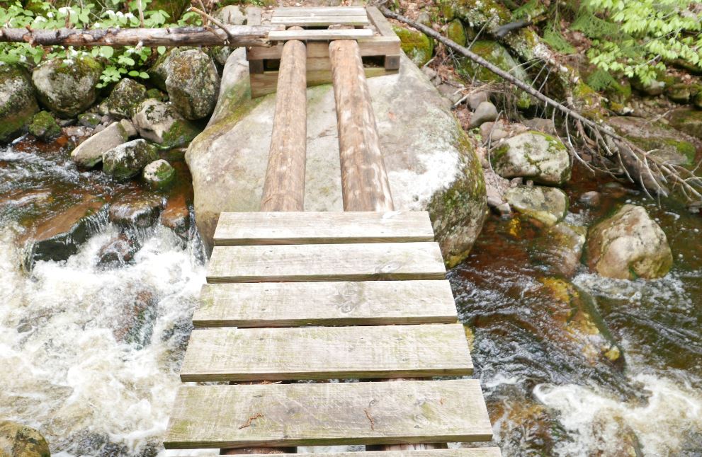
The NLPT bridge crossing Brown's Brook is missing half its' planking. It's not evident how it got into this state since it's a relatively new bridge; this section of trail was opened in just the last ten years. When the water is low you can rock hop to cross the brook and, if the logs are dry, you might chose to walk across the beams. On this day the logs were damp and slippery and I was not prepared to wade. So I headed up stream to find a place where I could get across with dry feet. On the way back I crossed the broken section of the bridge on my hands and knees using my hiking pole as a brace. It was not graceful but at that point I was not looking for style points.
Normally you might bypass the bridge and rock hop to cross the stream but two days of heavy rain had the brook running hard. I also considered walking the exposed logs but they were damp and slippery. Since I would be going up the valley anyway I figured the best bet would be to bushwhack along the stream until I found a place where I could cross. The first complication with that plan was that the banks of the brook are quite steep just above the bridge. So headed back up the trail to find a better spot to rejoin the brook. Eventually I did scramble down to the brook to take a look but the near bank was still quite steep and it was bordered by thick brush. Not ideal. More bushwhacking upstream expended a lot of energy but eventually I was able to get across with dry feet. My advice? Be prepared to wade this stream unless you know that the water is low.
A dense spruce thicket lines the north bank of Brown's Brook for a considerable distance above the NLPT bridge. It's a good 100 yards through this thicket before you emerge in the more open forest that lies beyond.
Getting to the far side of the brook revealed the next challenge. A spruce thicket lines the north bank of Brown's Brook and it took several minutes to find a way through and reach the open hardwood forest beyond. The spruce thicket along Brown's Brook is extensive and large spruce are present in the forest all the way to Dishrag Pond. This is notable because spruce were highly prized by loggers working this country in the early days of Adirondack logging. The abandoned road I would eventually find is seen on the first USGS map of the area published in 1903 and that probably means the area was logged before that date. The large spruce present today might have been too small to bother with back then and the passage of over 100 years has allowed them to reach mature sizes today.
The route to Dishrag Pond from the NLPT
Coming out of the band of dense growth along the brook I was unsure how far it was to the old road. Since I would be going up the valley either way I hedged my bets and set out towards a large unnamed vly that sits half way between the NLPT and Dishrag Pond. Following this course I would eventually reach the vly or find the path. After forty five minutes of bushwhacking pushed through a wall of brush I stepped out onto a clearly defined woods road. I'd hit the path at the point where the road forded the brook that flows out of the vly. The path, the brook and the vly came into view at the same time as did clarity as to where I was. A few minutes earlier I had thought that I'd have to give up on Dishrag Pond because of a lack of time, but this changed everything. The way was now clear. I could follow the old road to see where it goes.
The old road just above where it fords the brook flowing from the unnamed vly. Until I stepped out on to it I was not sure how distinct the way would be. This would be hard to miss.
Looking down the vly from the western end. This point is easily reached from the abandoned road that passes south of the vly.
From the vly to the vicinity of Dishrag pond the road is easy to follow but not easy going. Blowdown blocks the way in numerous places and the surface was consistently wet and muddy. Even so, I made decent time and just as I was starting to think that I must be getting close I rounded a bend to see the rusted hulk of a long abandoned car. The Ford coupe (I think from around 1940) had probably broken down at that spot and it has remained there ever since.
This abandoned car at the end of the old woods road provides known location for orienting yourself for the final push through the forest to Dishrag Pond. It appears to be a 1940 Ford Coupe and it probably broke down at this spot and was abandoned.
Just past the car the road ends. The 1903 USGS map shows the road reaching a small water body. If that was correct then the final stretch of road has been completely reclaimed by the forest. I couldn't tell exactly where the pond lay in relation to where I was, but, having come so far, I took my best guess and headed off through the forest one more time. What I learned is that the quarter mile between the end of the road and the string of beaver meadows below Dishrag pond is wet, very rough, and extremely thick. I hoping for at least a glimpse of Dishrag Pond but it was not to be. The pond couldn't have been more than a few hundred yards away, but it was 2:00 pm and getting there was going to take a while. So I turned for home. I'm unusually pretty good at retracing my steps through the woods and I tried to return to the spot where I had left the road. But even that proved to be difficult. As I said, the terrain is rough and the cover is exceptionally thick.
Looking across one of the beaver swamp/meadows just downstream from Dishrag Pond. The Blue Ridge is seen in the background.
If you want to reach Dishrag Pond leave the road 300 yards back from the place where you find the old car. Head north north west and stay in the hardwoods for as long as you can. I may have to return some day to see what Dishrag Pond actually looks like.
(1) Blue Ridge Wilderness Master Plan
(2) There is limited parking for the NLPT north at a pull-out on the Cedar River Road at Wakely Pond, The NLPT leaves the road at that point and enters the woods on a gravel road that can be driven a short distance to a pull out where additional cars can be parked.
(3) Current maps so the route as an unmarked path that ends at the vly halfway to Dishrag Pond. In fact it's an old woods road easily followed to a point a quarter mile from the pond.
Hikers planning to walk the Northville Lake Placid Trail (NLTP) from south to north have long faced a bit of dilemma in deciding where to start. From the official trailhead in the village of Northville the first twelve miles of the route were along paved roads and you would have walked 14 miles, at a minimum, to reach a place where you could camp. For that reason, many thru hikers started their journey at the so called "Upper Benson" trailhead on Godfrey road.
Two new sections of trail change that calculation completely. A thru hiker might still chose to start at Godfrey road but, if you do, you'll miss two compelling new segments of the trail. The first section runs from Collins Gifford Valley Road near Northville to the Benson Road; covering a distance of 8.6 miles. The second section links the Benson Road crossing with the original route at the place where the original route crossed the West Stony Creek North Branch (the bridge about 2 miles from Godfrey Road parking area). This second section covers seven miles and both sections together add 15 miles of new trail to the the NLTP.
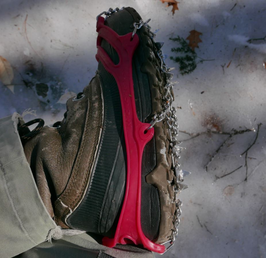
I recently walked significant portions of both of the new sections on successive weekends at the end of February and beginning of March 2016. Both trips, were made possible by the use of micro-spike "boot chains". In both cases the trails were extremely icy and neither excursion would have been possible without the micro-spikes (Images 1 and 2).
Image One
Image Two: Unusually icy conditions prevail in early spring 2016. Walking these trails would not have been practical without the use of micro-spikes.
The first of these two outings covered a portion of the the new trail that runs from the Benson Road to West Stony Creek North Branch (north of the Benson Road). The following weekend I walked the section starting at the brand new trailhead on Collins-Gifford Valley Road to the crossing of the West Stony Creek. Both hikes covered about ten miles for the round trip.
Notices at the trail registers warn that though a bridge is planned, currently there is no bridge over West Stony Creek. This is important for anyone planning to start a NLTP journey at the Gifford Valley trailhead because West Stony Creek is a significant stream. The creek can easily be forded at times of low water, but in the spring, or after heavy rains, it could present an impassable barrier.
Image Three: The only other hiker I saw on two full days of hiking is seen above on the far side of Stony Creek. He evidently hiked from the Benson road south to the creek crossing.
Not surprisingly, on the day I was there, March 6, 2016, fording the stream would have been a risky undertaking. West Stony Creek at the place where the trail crosses is wide and in early spring it carries a significant volume of water. The creek does look to be shallow, probably no more than knee deep, but with lots of ice and freezing water to contend with I can't imagine a casual hiker trying to cross at this time of year. The crossing will look completely different in six weeks and by mid-summer it might be possible cross without getting your feet wet. But without a bridge you need to factor the creek into any plan to pass thru this section. I shot a couple of short videos to illustrate.
I'm going to come back to these two outings in future posts, but for now I'll let a quick summary and some photos do the talking. Setting aside the value that these re-routes provide by finishing the long story of the NLTP, the first section, from the Collins Gifford Valley Road to the West Stony Creek crossing is a great new hiking route all on its' own. After climbing steadily for the first mile this section of trail enters a rapidly maturing oak forest that is notably different from forests along most of the NLTP. Then, at just under two miles you reach Mud Pond. The setting for the pond is attractive and open rock is visible on the ridge line northeast of the pond. The ridge appears to be easy to reach and probably has some nice views. I'm planning to return at some point to see for myself.
Image Four: Mud Pond in late winter splendor.
Past the pond the trail passes through a complex of small ridges coming down from the surrounding mountains and it crosses two stream carved valleys. Along the way the forest transitions to a more typical mix of Hemlock and northern hardwoods. This is a very attractive section of trail and the second major stream crossing, about a mile from Stony Creek, is at the head of a small gorge that also looks to be well worth a visit with time to explore.
Image Five: Details seen along the trail.
At just under five miles the trail reaches the ford of West Stony Creek. The area of the crossing, on the south side of the creek, looks to have a number of attractive potential camping spots and I suspect that this will become a well used destination.
All in all, the five mile stretch south of Stony Creek is a lovely hike on its' own terms and I have no doubt that I will return soon. When it is possible to cross it's 2.8 miles from the north bank of the creek to the Benson Road. Walking that section of trail is near the top of my list of possible future outings.
The second of my two recent hikes started at the Benson Road and covered the first five miles of the seven mile route to where the new trail joins the prior route of the NLTP. That outing was similar to the one I've just described with very ice trail conditions defining the day. The highlights of this section include the passage of Woods Lake; a long-time favorite local destination. Along the mile long shore of the lake the trail traverses some splendidly rugged terrain in crossing a ridge of Little Cat Head mountain. Little Cat Head reaches barely 2000 feet in elevation but it's an intriguing mountain with potential viewpoints. From the ridge to the point where I turned around the trail passes through mostly young second growth forests with sections of more mature Hemlocks along a couple of small ridges. I suspect that the section from where I turned back to the place where the new trail joins the old route is more interesting, but I had to leave that for another day. The Ten mile round trip --crunching along over icy ground the whole way-- is my limit for this time of year.
Image Six: Glare ice along the shore of Woods Lake. Heavy rains in the prior week followed by a temperature plunge to near zero created hard ice conditions.
Kempshall Mountain, elevation 3380, lies just east of Long Lake in the southwest corner of the High Peaks Wilderness. The mountain's only real claim to fame is that a fire tower previously stood on the summit. The tower was closed in 1971 and removed from the mountain in 1977. By 1990 the trail to the top was officially abandoned. The old trail can be reached on foot by hiking north on the Northville Lake Placid Trail (NLPT) from the Tarbell Hill Road trailhead just east of Long Lake village. It's 4.5 miles From the parking area to the trail junction. Old guidebooks to the NLPT listed Kempshall as a two mile side trip with good views of the high peaks. But, without the tower, there are no views and recent editions have noted that the trip up Kempshall is "not recommended".
Wow, an abandoned trail listed as "not recommended". For me that's an irresistible combination. Views are not everything and these routes are often times fascinating for other reasons. That was certainly the case for the climb up Kempshall. Hopefully you can get a sense of it from the pictures.
Snow had fallen two nights before but as I hiked the temperature rose to above freezing. I was fascinated by the changing conditions as I climbed from the notch at 2300 to the top of the mountain at just under 3400 feet. At the lower elevations the snow plastered on every tree was transitioning directly to water and every gust of wind produced a shower of cold water.
Most of the day was heavily overcast, but occasionally the sun burst through.
A few of the old State trail markers can still be seen along the trail.
Setting off I didn't know what to expect. This trail is mostly forgotten but would it be hard to find or follow? The answer to that question is a definate no. The junction where the Kempshall Mountain trail leaves the NLPT is not marked, but it would be hard to miss. And the first mile of the route follows an old tote road to a notch between Kempshall and Blueberry mountains. On top of that, it soon became evident that the trail has recently been brushed out. Someone has cut back the small trees that quickly obscure abandoned paths in this neck of the woods. In a few cases larger blow down had been cut as well, up to the size that you might tackle with a hand saw.
After about a mile of moderate uphill hiking the path crosses a pretty little brook and steepens. At that point, at about 2300 feet, the trail enters a particularly dense spruce-fir thicket. The trail narrows and the trees close in. The route then alternates between moderately steep and very steep as it climbs 1000 feet in less than a mile. It was in this stretch that the recent work on the trail became highly evident and much appreciated. Blow down blocking the trail had been cut and, in places where rerouting was necessary, marker ribbons had been added to show the way.
The fire tower site is completely hemmed in by the forest. The tower foundations are evident, so I know that this was the spot, but there no openings for views. Even so, the trees, the snow and the light produced some appealing images.
Despite the recent work it's safe to say that the Kempshall summit does not get a lot of visitors. The climb up from the notch, and the summit itself, have a distinctly wild and forgotten feel. Totaling 13 miles for the round trip, with a steep climb for the last mile, the hike demands endurance even in summer. Doing the hike in mid-November it was an adventure. I was prepared for early winter but I had not anticipated the large amounts of water coming off the trees. I was pretty wet when I got to the top and my slow pace on the steep and icy descent meant that it was dark when I got back to the car.
The last time I stood on the suspension bridge that carries the Northville Lake-Placid Trail over the West Branch of the Sacandaga at Whitehouse I was around 10 years old. That was close to 50 years ago.
Image 1: Bridge over the Sacandaga West Branch. The bridge crosses over a rock outcrop in the center of the river (now covered with trees). The total length of the two spans is close to 300 feet.
That visit took place during a family camping trip to the State Campground on the Sacandaga River just south of Wells. My family was one of a half dozen families who regularly camped together at various campgrounds around the State. My childhood was punctuated by those trips. If I remember correctly, on this particular outing, a couple of the Dads decided to take a bunch of the kids on a hike. The bridge at Whitehouse was new at that time and a 300 foot long suspension bridge over a major river was well worth a look; especially since several of the Dads worked for what was then called the New York State Conservation Department. I don't actually remember the bridge but I know we stood on it because there's a family photo to prove it. What I do recall is that we hiked to a place where a USGS benchmark was set into a boulder alongside the trail. There is a benchmark noted on current maps about a mile north of the bridge on the NLPT so we probably went that way.
On my more recent visit (September, 2015) I did cross the bridge. I was headed for Canary Pond and I thought I might try to go the extra couple of miles to reach Silver Lake from the north. But I turned back at Canary Pond and the nearly 14 mile round trip was plenty of hiking for one day. It took me nine hours to walk that route and a big reason for that was that it was an absolutely gorgeous early fall day with the leaves just starting to turn. I took lots of picture and that takes time.
Image 2: West Branch Sacandaga looking south from the bridge at Whitehouse.
The human history of the area is described in fascinating detail by Bill Ingersoll in Discover the Southern Adirondacks. As Ingersoll notes, the first settlers to the area arrived in the 1850s and over the roughly 100 year period between settlement and acquisition by the State the land served many uses. The first settlers may have attempted to farm the land but the long winters and thin soil would have discouraged that idea, and from 1900 onward a succession of hotels, hunting lodges and finally a boys summer camp occupied the site. The surrounding wilderness has been owned by the state going back to the late 19th century and the 350 acres where the bridge is now located were acquired in 1962.
The hike south to Canary Pond passes through a rapidly maturing 2nd growth hardwood forest. The Silver Lake Wilderness lies in what was once part of the great northern hardwood forests that covered most of New York State. Sugar Maple, Yellow Birch, and American Beech were the dominant tree species and, today, stands of Birch and Maples are rapidly approaching maturity. The Beech are mostly gone; killed off by Beech Bark Disease. This route passes through forests where many trees are approaching 36 inches in diameter with a few larger ones mixed in. There are also stands of Hemlock and I measured one Hemlock on the slope leading up to Mud Pond Notch at 47 inches in diameter.
One of the more interesting sights along the way to Canary Pond was the beaver dam on a small stream between Mud Pond and Canary Pond. This dam is (or was) an engineering marvel. On the day I hiked the route (Sept. 27, 2015), it was very dry; northern New York State had received below average moisture for the year and August and September were notably dry. The beaver had managed to completely block the stream and the outflow below the dam amounted to barely a trickle. As seen in images 3 through 6, the beaver pond was quite large -over 6 acres as measured in Google Earth- and water was backed up to the very top of the dam. Unfortunately for the beaver shortly after my visit the area would receive between three and four inches of rain in a 24 hour period. I have to wonder if the dam stood up to that deluge.
Image 3: Beaver Dam along the trail between Mud Pond and Canary Pond
Image 4: The pond the beaver build.
Image 5: Looking up at the dam from the stream bed. The water in the foreground was standing water in the stream bed. Almost no water was getting through the dam.
Image 6: Looking back across the pond from the far side. The dam,, and the vantage point for the three pictures, is in the farthest distant corner of this shot. On the far shore left of the beaver house.
I'd be interested to know if the the dam stood up to the heavy rain but I'm sure the beaver will manage, they have been damming this stream for centuries if not longer. Using our ability to view historical imagery in Google Earth we can see that over just the past 15 years the pond pictured above has filled and drained several times. The sequence of images that follows comes from Google Earth showing imagery from 2013, 2011, 2009, and 2006. From this we see that the current large pond was created since the date of the most recent satellite imagery for this area dated from August 2013.
The yellow lines in image seven are the tracks capture by my GPS. There are two lines because one is the track on the way to Canary Pond and the other is the track from my return trip. As you can see, the lines don't overlap, and the difference averages around 30 feet. I keep promising to write more about GPS accuracy, and explain why the tracks differ by that amount, so maybe I'll get around to that soon.
Image 7: The beaver pond/meadow as seen in Google Earth imagery from August 2013.
Image 8: The beaver pond/meadow as seen in Google Earth Imagery from May 2011. You might also wonder why this image is "fuzzy" when compared with the one from 2013. The most recent round of imagery used in Google Earth (as seen in image 7) is at a higher resolution than was previously available.
Image 9: The beaver pond as seen in imagery from May 2009. The beaver had dammed the stream and filled the pond.
Image 10: The beaver pond/meadow as seen in Google Earth Imagery from June 2006. The dam was out and the pond was a grass-filled meadow.
I did eventually make it to Canary Pond, a lovely and remote body of water (Image 11). Along the way you pass Mud Pond, site of a lean-to that is in particularly good shape. Ingersoll says that the appreciation of Mud Pond requires a special aesthetic (images 12 and 13) and for tired through hikers on the NLPT the difficulty of getting to the pond to get water probably does lead to a bit of cursing. But I thought it was pretty enough and marshes look to me like an exceptionally good place for bird watching. By the way, the stream that Ingersoll mentions as a source of water for campers staying at the leanto, was completely dry on the day I was there.
Image 11: Canary Pond
Image 12: Mud Pond
Image 13: The path over the outlet of Mud Pond. A split log bridge passes through and should keep feet dry most of the time.
Image 14: Fall foliage along the Sacandaga West Branch.
As with Fishing Brook Mountain, Burnt Mountain is visible from Route 28n just east of Long Lake. It's a small peak --just 2600 feet-- and it would go mostly unnoticed except for the areas of open rock that are clearly visible near the summit. I have long wondered about the view from those rocks. Given that the summit is less than a mile (as the crow flies) from the Long Lake Reservoir I figured it could be done in a few hours; maybe a half day.
Taking advantage of the 4th of July holiday I set off to see. Turns out there are very good views. From the summit the view to the north is mostly open and with some exploring good views can be found for nearly every direction. I was a bit over optimistic on the difficulty however; the trip was not quite the half day outing I had expected. The seven mile round trip took 6 hours of nearly continuous walking and by the end I was very happy to see the car. Pretty much every bushwhacking trip I take turns out to be harder than expected. Maybe there's a lesson to be learned from that. Nah, the next one is bound to be easy.
From the summit of Burnt Mountain. Looking Northeast towards the High Peaks.
From the summit of Burnt Mountain, looking Northwest; Click on the photo to see the full size image and you can just make out a sliver of Long Lake in the upper left. Kempshall Mountain is the prominent rounded mountain in the right center with Blueberry Mountain just to its' left. Blueberry Mountain is another one of those trail-less and infrequently climbed peaks with great views. In the full image you can make out some of the south facing open areas on Blueberry mountain. And there are extensive open rock areas on the west side with great views of Long Lake.
From an opening on the south side of Burnt Mountain looking Southwest towards the west end of the Fishing Brook Range.
Overview of the route. The first mile and a half is along the Northville Lake Placid Trail (NLPT) from Rte 28n. On the way up I passed the Long Lake Reservoir and walked due east until the slope steepened and turned south to angle towards the notch. For the return I followed the small brook that flows out of the notch on the south side of Burnt Mtn. down to Sandy Creek. Crossing the creek I continued west until I ran into the NLPT. As the day warmed the flying vermin started to find me in large numbers and I was highly motivated to find a trail where I could move along at a quicker pace. (image from Google Earth)
Google Earth terrain view showing my circuitous route around the summit in more detail. The open rock on the left seemed like a good bet for by-passing the conifer thickets seen here in darker green, but the rock was a little steeper than liked for a solo bushwhacking trip so I beat my way through a lot of brush.
I hiked up to the notch on the south side of the mountain (on the left) and climbed up to the summit from there. That route was steep and passed through areas of dense thicket. Seeking an easier route I came down the east ridge (on the right). That way was much easier but left a climb of a couple hundred feet back up to the notch.
It may be that the easiest route up Burnt Mountain is not up from the notch on the south but instead would work around the mountain on the north side and up the northeast slope to the top (upper right in the photo). The second growth forest on the north side of the mountain is Beech-Maple though nearly all of the large Beech trees have succumbed to Beech Bark Disease (BBD). Still, the forest is relatively open and easy to navigate with large Maples and Yellow Birch that I estimate to be in the 80-100 year age range. The only issue with climbing the mountain from the northeast is that the state land boundary crosses Burnt Mountain just east of the summit. So staying on public land might force you onto a less desirable route.
Spiders gotta weave
As always I was on the lookout for ecological anomalies. I didn't spot anything really notable but the notch on the south side of the mountain is pleasant and feels remote. The forests south of Rte. 28 are mostly mature second growth consisting primarily of Sugar Maples, Yellow Birch, Hemlock and on the higher slopes, Spruce.Many trees have reached full height with ABH diameters greater than 24 inches with a smattering of older trees with diameters approaching 36 inches. One notable tree was a Beech seen on the northwest slope of the mountain with a diameter of 36 inches. It was tipped up from the roots sometime in the past year or so but it looked to have been in good shape when it went over. The wood was still sound and there was very little indication of BBD. Had I seen it before it went over it would have been a notable specimen. One final note; my father grew up in Long Lake and hunted in these woods as a young man in the 1950s. He tells me that there is an interesting cave somewhere in the notch on the south side of Burnt Mountain. No doubt the forests are much thicker there now because I saw no sign of it. Maybe next time.