This was my second ramble to the vacinity of the top of Blueberry Mountain. This particular Blueberry Mountain is located just south of Kemshall Mountain; a mile from the east shore of Long Lake. I had previously bushwhacked up the mountain from a point on the Northville Lake Placid Trail about 3.5 miles north of the NLPT parking area on Tarbell Hill road. The route I took on that first trip was very steep and it passed through a dense swath of Spruce and Balsam. At the time I decided my route was ill chosen and in fact I came down the north side of the of the mountain where I stumbled on the old trail up Kempshall Mountain. Since then I've been back and
followed the abandoned trail to the top of Kemshall. That route climbs to a saddle between Kempshall and Blueberry and I figured that the best route up Blueberry would be to follow the old trail to the saddle and then bushwhack to the top from there. This is indeed the easier way to go.
 |
| A low cloud cover limited views from near the summit of Blueberry Mountain. |
But the main reason to hike Blueberry again was that my brother Mike was visiting from Colorado and we were looking for a good outing. Something close to town, of moderate length and hopefully with views. Blueberry normally has fantastic views and I figured it to be a 12 mile round trip with the last 1/2 mile a bushwhack up from the saddle. That seemed like the right mix so off we went.
And we did reach the top basically as planned. The bushwhacking stretch was a little harder than anticipated but 45 minutes after we left the old Kempshall trail in the saddle we came to a boulder with a small cairn on top of it. There didn't appear to be any more "up" anywhere around so we declared that point to be the summit. As for the view, the top of Blueberry is in the elevation zone where dense stands of Spruce and Balsam typically dominate. And the cover on summit of Blueberry varies between dense and very dense. However, I knew from my prior visit that open rock slabs exist on Blueberry with great views. Searching around on top we did find some rock outcropings that could have had good views. Unfortunately, as the day had progressed the thick overcast had lowered until visibilty from the top was on the order of a quarter mile. Basically we were staring off into the clouds.
 |
| Yup, still limited over on the other side of the summit area. |
 |
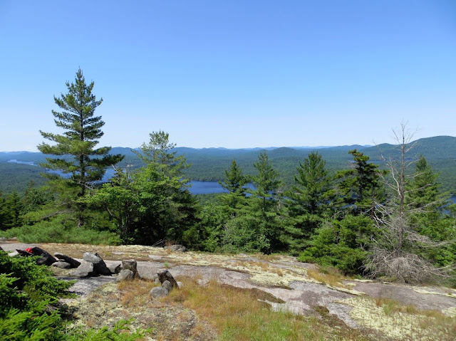
| There it is, the view, looking southwest from one of the open areas near the summit of Blueberry Mountain. This shot is from my prior visit in July of 2014. |
Still, I assured Mike that there were two large areas of open rock where good views would normally be found and that maybe we could sneak a view through the clouds from one of those areas. After half an hour of searching, beating through the thickets, I sensed that Mike was starting to doubt that these "open areas" even existed (Ok, it didn't require any great powers of perception, he readily pointed out that this was his theory). Eventually we paused for lunch at a place near where we had first reached the top.
 |
| Screen capture from Google Earth showing our route. The orange line is the GPS track. The yellow line is the trail overlay from the New York State Dept. of Environmental Conservation trails map. This version (of the overlay) still shows the trail up Kempshall Mountain. That trail is officially abandoned and while still easy to follow it is not a marked trail. |
 |
| A broader perspective on our route and the summit of Blueberry mountain. Kempshall is in the background. |
Returning home the GPS track told the tale. We had circled around the summit of the mountain and the two large open areas (yes, they do exist) are slightly lower down; one on the west side and one on the east. We had come close to each one but had not gone far enough down the slopes to break out into the open. Oh well, there wouldn't have been views anyway. That is the story I'm sticking with. Now I'll just have to make the pleasent walk down the lake and up Blueberry again to see those great views. It could be worse.
 |
| Along the shore of Long Lake near the point where the abandoned Kempshall Moutain trail intersects with the NLPT. The lake is very low, even for this time of year (Oct. 1). The summer has been unusually dry and hot |
 |
| Long Lake from near place where the picture above was taken. The bushes in this photo are also in the previous picture. In that one seen from the side. A point was under water when this picture was taken in July of 2014. |
 |
| Forest scene from along the NLPT along the way to Blueberry Mountain. |
 |
| Another forest scene. From July 2014. |
 |
| Near the top of Blueberry Mountain. Previous visitors had built chairs from which to watch the sunset (one might imagine). |
 |
| Near the top of Blueberry Mountain. July 2014. |
 |
| Near the top of Blueberry Mountain. |
 |
| Lichen, near the top of Blueberry Mountain. |


