Snowy Mountain has a reputation as the high peak that got away. Snowy is the tallest mountain outside of the high peaks and, at 3904 feet, it is the 46th highest mountain in the Adirondacks (two of the original 4000 footers; Nye and Couchsachraga were found to be less than 4000 feet by later more-accurate surveys). But even more important to Snowy's reputation is its' striking and rugged profile. The east side of the narrow summit ridge is framed by large areas of open rock and to the west the ridge falls away steeply to the Squaw Brook Valley, 1500 feet below.
The Snowy Mountain summit ridge from Google Earth. The orange line is my GPS track.
Snowy is also known for having great views and I found the western vista to be the most striking. Snowy is the high point in a range with a half dozen summits exceeding 3700 feet in elevation and, except for Snowy itself, these peaks are un-tracked and rarely visited. The western view from Snowy looks out over a sea of wilderness.
Northwest from the summit of Snowy Mountain. Panther Mountain -elevation 3865 feet- (far right in the photo) is the high point of the range that frames the west side of the Squaw Brook Valley. The valley floor is 1500 feet below the ledge where this photo was taken.
Looking southwest from Snowy Mountain. Lewey Mountain (elevation, 3720 feet) is the prominent cone in the center. The rarely visited Blue Ridge (elev. 3881 feet) is visible in the distance.
Buell Mountain (elevation 3740) is directly across the valley from Snowy.
Looking northeast towards the High Peaks. This view was from midway up the tower. There are open ground-level views to the east and west, but you'll need to climb the tower to get a 360 degree view.
Looking over Indian Lake from the site of the (removed) observer's cabin.
The Snowy Mountain trail is reminiscent of the high peaks experience in other ways. Lots of people climb this mountain; and the boots of many hikers, combined with the steepness of the upper sections, has resulted in a muddy and heavily eroded trail. Recent trail work has greatly improved the first two and a half miles making it a pleasant walk through an, attractive, middle-aged forest. At that point you'll have a mile --and 1500 feet of elevation-- remaining. The trail climbs steadily at first and the last half mile is very steep; following the course of an old, overgrown, slide. This section is rough, muddy and eroded but not particularly difficult. The trail breaks out onto a large ledge at the former site of the observers cabin and then continues a short distance to the fire tower. The tower is in good shape, and can be climbed to the top for 360 degree vistas. A small ledge on the west side provide open views in that direction.
Squaw Peak looms over the trail on the steep upper section of the route. In places the trail is heavily eroded, but a lot of work has been done to improve the experience and reduce the damage done by thousands of hikers.
Our recent (partial) move to Long Lake makes it a lot easier to head out for a few hours and on the last two weekends I've done just that; kayaking on Little Tupper Lake for one outing and hiking Owls Head mountain on a separate day.
Little Tupper is the center piece of the William C. Whitney/Round Lake Wilderness area and the put-in is just a 20 minute drive from Long Lake Village. If canoeing or kayaking on wilderness lakes is your thing; it's hard to beat Little Tupper Lake.
Little Tupper is six miles long and averages about 3/4s of a mile across. It's a big lake, and its' alignment with the prevailing westerly winds means that it can get rough when the wind blows. As the signs at the wilderness headquarters note; if the wind starts to blow, or a thunderstorm approaches, head for the shore.
The day I was there was pretty calm and what wind there was came out of the south. This made it a good day to tool around in my little 'sport' kayak; not a boat you'd want to be out in on a day when the lake was roughed up. From the landing I paddled across the lake and then followed the south shore towards the lake's major inlet, Rock Pond Stream. As the crow flies it's about five miles from the headquarters to the head of the lake and, with some time added in for exploring, it took nearly two and half hours of steady paddling to get there. I had thoughts about continuing into Rock Pond Stream and possibly all the way to Rock Pond. But I didn't go far before the Black Flies and Mosquitoes convinced me that this was not a good plan. Besides, calm, sunny, morning had given way to increasing clouds and a freshening breeze. So it was time to head back. Working my way back along the northwestern (opposite) shore made for a round trip covering about 11 miles. A good workout in a 10 foot kayak designed for doodling around on small lakes and ponds.
Little Tupper hosts a solid loon population. This pair popped up close to my kayak and I was able to get off a couple of quick shots before they disappeared again.
Looking down the lake (to the northeast) towards the Ranger Station
Near the head of the lake, looking southwest. The inlet coming in from Rock Pond is maybe a mile further along the shore.
The stream from Rock Pond is easily navigable by canoe or kayak, with one short portage. Rock Pond itself is a large body of water and well worth a visit. But not on this early June day. Out on the lake the breeze was enough to keep the bugs away but close to shore the breeze dropped and bugs literally swarmed in. Run away!
Part Two: Owls Head Mountain
Owls Head mountain, with it prominent fire tower, is visible throughout the village of Long Lake. And the climb is a favorite of both visitors and residents. At just over three miles, with 1100 feet of elevation gain, this hike provides a sense of accomplishment without requiring a whole day.
And the views are well worth the effort. There are good views to the east, northeast and southeast from the rocks below the tower and a local volunteer group is maintaining the tower so you can climb up and get a nearly 360 degree vista. I don't know when (or if) the cab at the top of the tower is opened, but the highest landing provides clear views in all directions.
Blue Mountain, looking southeast from Owls Head. The south end of Long Lake in the foreground. South Pond is a bit further out towards Blue Mt.
Looking Northeast over Long Lake, the High Peaks in the distance.
Looking south from the tower it's an unbroken forest as far as you can see. You have to climb at least part way up the tower to enjoy this view.
The Owls Head tower is being maintained by a local volunteer group. Climbing up to the landing below the cab opens up views to the south and west that cannot be had from the ground.
Looking mostly south. Snowy Mountain is the dominant peak in the distant ridge.
The title pretty much says it all. Elle and I have bought a house near Long Lake and will be living there, part time for now. That's a story in its' own right and, off topic for this blog, except that living in Long Lake will make it possible to get out and enjoy the great north woods more frequently.
The snow part comes from the snow storm that hit the Adirondacks on our moving week-end; the last weekend of April. On Saturday morning we drove a UHaul up filled with all the stuff for the new house. Then, with lots of help from family we got everything inside just before it started to rain (thanks family!). Saturday night we slept in the new house and on Sunday we got up to watch a steady rain change over to heavy snow. You know, the big flakes you get when the temperature is right at 32 (f). At first the snow melted on contact with the ground but, it kept coming down, and as surfaces cooled it started to stick. By mid-afternoon grassy surfaces had accumulated a couple of inches and roads were starting to slick up. That seemed like a good time to head out for a short hike.
The drive over to the Owl's Head Mountain took, maybe, 10 minutes. Even so, it was 3:00 pm when I left the car. Given the conditions that was too late to head for the top but I had an alternate route in mind; the side trail that connects the Owl's Head Mountain trail with the southeast end of Lake Eaton.
A pleasant mile and half brought me to Lake Eaton while the snow continued to pile up. Winter has lingered this year and Lake Eaton was still entirely ice covered despite being just two days shy of May. A picture and a short video tell the rest of the story.
Lake Eaton, April 29th 2018. Ice covered and snow falling. The great thing about living in the mountains is that given a spare couple of hours a quick walk leads to a wild scene.
March is the coolest month? I'm trying to get used to the sound of that but, after many years of saying that "March is the cruelest month" it will take some time. March's cruelty lies in the teases of spring that show up in a month that is still very much winter. But change is in the air; Elle and I are embracing our north country roots and buying a house in Long Lake. So instead of living in Saratoga Springs and heading up north on weekends, we'll be living in Long Lake and heading down to Saratoga when work demands it.
The trail to Wilson Pond was unbroken so I found myself plowing through deep snow the entire way. The going was still tough on the way out, even with my own tracks to follow.
As I write this post it's March 19th and tomorrow is the vernal equinox; the official first day of spring. In the past I might have lamented the fact that nearly three feet of snow had fallen in the past week. Or that the overnight temperature had fallen to ten below zero. But, we are moving north by choice so we might as well embrace March as our last chance to enjoy winter before the pesky bugs and tourists return. March is the coolest month.
Snow floating down from the trees, glimmering in the late afternoon sun. It's still winter, but the sun has a warmth in March that is not there in January.
Setting off on the Wilson Pond trail (trailhead on Rte 28, just south of Blue Mountain Lake), my only goal was to enjoy this last (I hope) blast of deep winter. Given the soft, deep, snow I was using the big Sherpa showshoes that I rarely use anymore. But even the Sherpas were not enough to keep me afloat on the unbroken track. Sinking in eight to twelve inches on every step was exhausting and made for very slow going. After two and half hours I had covered just two and half miles, and decided to turn back. I like to take my time and enjoy the solitude on these outings.
Grassy Pond. A half mile from route 28.
The trail to Wilson Pond passes through a chain of beaver ponds and meadows.
The snow depth is evident in this photo. Small stretches of this stream had remained open during the recent storms but had frozen over during the colder stretch that followed.
The late afternoon sun
Blue Mountain, with it's prominent communications towers, is visible at several points along the way.
Winter is going to spill over into the spring this year. It will take a few weeks for this snow to melt.
The "plan" was to hike to Upper Sargent Pond starting at the Minnewaska Conference Center near Blue Mountain Lake (Castle Rock Trail). But, I didn't get far before realizing that I wasn't going to make it to Upper Sargent (4.5 miles ). A mix of rain, freezing rain, and snow had fallen throughout the morning and a blustery wind was blowing. I delayed my departure until noon, hoping that the weather might improve, but it was still raining as I walked away from the car. On top of that, trail conditions alternated between soft, deep, snow and hard ice making for slow going.
An unnamed peak on the Castle Rock Ridge.
After a slow three miles it was an easy call to turn back. I didn't have enough time to make it all the way to Upper Sargent and out before dark, and going back would make a couple of short side trips possible. The first would be a quarter mile bushwhack into the narrow valley between Little Blue Mountain and the Castle Rock Ridge to visit Helms Pond. The second would be a side jaunt up and over Castle Rock. The Castle Rock loop trail coincides with the Sargent Pond trail for the first mile and by going over Castle Rock I could return to the car by a different route.
The Castle Rock and Upper Sargent Pond Trails
No One Goes Here
Depending on the activity of the local Beaver population, Helms pond is a series of swampy ponds or one larger body of water. The Sargent Pond trail passes within a quarter mile of Helms Pond but it's not exactly trivial to get to the waters edge. There's a steep descent down to the shoreline and the pond protected by a band of thick underbrush. In short, Helms Pond is uninspiring, out of the way, and not easy to get to. Stepping out of the thick growth, my first thought was, "no one goes here."
Little Blue Mountain (2800 ft) looms above Helms Pond.
Looking north across Helms Pond towards little Blue Mountain.
Looking east, down the length of Helms Pond.
The Place That Everyone Visits
Castle Rock, on the other hand, is one of the most popular hikes in the region. The 3.5 mile loop route features iconic views of Blue Mountain Lake and the scramble up the last 200 feet to the top adds a bit of excitement. It's steep and exposed and, on the day of this outing, it was coated with a sheet of hard ice.
The views from Castle Rock are exceptional and it's relatively easy to reach the top. So a lot of people make the climb. The trail is heavily eroded and the summit area has been seriously degraded. Castle Rock is more of a tourist destination then a wild environment.
From Castle Rock looking east over Blue Mountain Lake.
An apparently unnamed peak west of Castle Rock. Pine Pond sits just on the other side of this mountain so let's call it Pine Pond Mountain.
A broader view including Pine Pond Mountain with Eagle Lake and Utowana Lake on the left.
Late January, sun shining, moderate temperatures; a perfect day for a hike in the Pharaoh Lake Wilderness. My plan was to follow the Sucker Brook Trail for four miles and then go off-trail for half a mile to the top of No. 8 Mountain. And I did reach to the top of a mountain. It's just that it was not "No. 8 Mountain". Its' name is actually No. 8 Hill; a distinction of no interest, except, there actually is a separate mountain, named No. 8 Mountain, located just two miles away. That's a bit confusing.
Pharaoh Mountain, seen from No. 8 Hill. This view of the imposing western face of Pharaoh Mountain is as good as it gets.
If you've seen the movie The Englishman Who Went Up a Hill but Came Down a Mountain you might imagine that the distinction between No. 8 Mountain and No. 8 Hill is based on some physical characteristic that separates the mountains from the hills. In the movie, the inhabitants of an isolated Welsh town are told that their "mountain" is only a hill. They got the downgrade because their mountain was just shy of the 1000 foot minimum used by the UK Ordinance Survey as the defining characteristic of a mountain. Apparently, British geographers of that period had a lot of time on their hands. In the U.S. the Board of Geographic Names steered clear of such arbitrary distinctions. In any case, with an elevation of 1945 feet No. 8 Mountain doesn't meet a standard that might separate it from its' slightly lower neighbor. The summit elevation of No. 8 hill is just 100 feet lower at 1850 feet.
The USGS 1953 Paradox Lake Quadrangle map (1:62500) shows both peaks. This is the first edition where the name No 8 Hill appears. The Sucker Brook trail passes just north of No. 8 Hill but is not shown on this map.
Barbara McMartin mentions No. 8 Mountain in her book Discover the Eastern Adirondacks. She describes an approach from the south as an easy off-trail climb, with ledges offering good views to the south. From where I left the trail the climb of No. 8 Hill is steepish, you gain 650 feet of elevation in less than half a mile. Nearing the top I was a bit surprised to find it to be a rocky knob protected by a band of cliffs and jumbled piles of large boulders. Contouring around the summit knob looking for a way up I made one false start; steep icy slabs blocked the way so I retreated to seek a less exciting route.
Looking northwest from the summit of No. 8 Hill. The Dix Range of High Peaks region is visible in the distance. 3700 foot Hoffman Mountain is seen on the left side of the photo.
Eventually I found a manageable way up. But, while taking the last few steps to the top it struck me that it had been a bit more challenging than I had expected. And the view that unfolded in front of me was also a surprise. McMartin described No. 8 Mountain as having good views to the south, towards Brant Lake. But the mountain I was on offered spectacular vistas with an unobstructed 180 degree view to the north, east and west.
Looking towards the southwest. Crane Mountain is visible in the distance.
It still had not sunk in that my recollection, and reality, were out of sync. So when it was time to descend I walked around the surprisingly large summit looking for an easy way down. Descending the south facing slope was promising at first, but the way was soon blocked by small cliffs. Going back up, I then headed down the western flank of the mountain. This route was also relatively gentle at first but, after a few minutes of descending, I found myself on an extremely steep and icy slope. Steep enough that I considered going back up to the top one more time so I could descend the route I followed on the way up (better the devil you know). But, by this point the afternoon was showing signs of wear, so I forged on, moving very deliberately. Within a few minutes I was back on easier terrain. The final difficulty coming in the crossing of a steep-sided little ravine filled with snow that had sloughed off the rock slabs above.
Looking towards the southeast. Glimpses of Lake Champlain are seen in the foreground with the Green Mountains in the distance.
This is a great little mountain (hill), and, on a warm summer day, the scramble over the steep upper slopes will seem far less daunting. Hiking solo, off-trail, in the winter, on the wrong mountain, you have to be cautious. The starting point for the Sucker Brook trail is five minute drive from the Hamlet of Adirondack on the eastern shore of Schroon lake.There is a large parking area.
The GPS track for the route described in this blog post.
The trail network at Moreau Lake State Park is getting two well-considered new additions. As of December 2017 one of the new trails has been completed and the other has been marked but not yet finished.
Rock formations along the new trail that connects the Lake Anne trail with the East Ridge trail.
The completed trail joins the Lake Anne Trail halfway between the S9 intersection and Lake Anne itself. From there, the new route runs for about one mile to intersect the East Ridge trail (blue). Like most of the trails at MLSP this one is interesting and well built. The new trail is represented by the heavy burgundy line in the map below.
The other new route has been marked with streamers but the path has not yet been improved. This route is represented by the black line on the map above.
In 2016, trails built in the newly added Lake Bonita section of the park connected with existing trails to create a very attractive loop hike covering six miles. In terms of hiking routes at MLSP, this route was an instant hit. Starting at the Lake Bonita Parking area the route follows the shoreline of Lake Bonita, visits Lake Anne, passes close to the popular Hudson River overlook above Spier Falls Road and then returns to Lake Bonita following another new section of trail. The only catch is that route requires descending nearly all the way to Spier Falls Road and then regaining that elevation to return to Lake Bonita. That's not necessarily a bad thing but, if you knew the terrain, it might have occurred to you that it would be possible stay on the ridge and complete the circuit without the extra climb. That's what this second new trail, when completed, will do. It will join the existing trail between intersections S13 and S9 and allow the loop described above to without the descent and extra climb.
It's easy to forget that nearly a million acres of the Adirondack Forest Preserve lie east of the Northway (I-87). The eastern section includes Lake George, Schroon lake and the New York side of Lake Champlain; all significant attractions. But, for hikers, the undisputed crown jewel in the east is the 45,000 acre Pharaoh Lake Wilderness (PLW). The PLW encompasses mountains with open summits and boulder strewn slopes. Nestled among those peaks and ridges are some of the most attractive lakes and ponds in the Adirondacks. And the area was settled --and logged-- early on, so a matrix of surprisingly mature second-growth forest blankets the landscape. I've hiked in the PLW before but my last visit was over 20 years ago. So my recent walk to Rock Pond --4.5 miles via the Short Swing Trail-- was an eye opener. The Pharaoh Lake Wilderness is an outstanding hiking destination.
Honey Pond. A semi-permanent, shallow, pond. The size of the pond varies based on the vitality of the local beaver population. As of December 2017 the outlet is solidly dammed and the pond has flooded sections of the Short Swing trail (getting around the wet areas is not difficult).
At these latitudes the late December sun never gets very high in the sky. This picture was taken near Lillypad pond at about 1:00 pm.
As mentioned, I've hiked in the PLW before and this was a favorite destination for family hikes when our children were children. In fact it was at Pharaoh Lake, nearing the end of an epic, six day, family backpacking trip that our nine year old daughter uttered one of the most memorable lines in our family history;
"We've been here for a week, we are out of food, and our parents don't care."
We were getting low on food and she and her brother were sick of our freeze-dried fare. She used that line to extract granola bars from passing day hikers. Once Elle and I caught on we had to put a stop to her "gathering" activities. But I have to admit, we were all pretty sick of backpacker food at that point and I was tempted to let her keep trying.
Rock Pond has an attractive rocky shoreline. Via the Short Swing Trail and Lillypad Pond trail, it's about 4.5 miles to reach the western end of Rock Pond. A mile-long trail goes around the pond and a shorter approach can be made from Putnam Pond.
Major trails enter the PLW from several directions and easy access is part of the appeal of the PLW. Two trail with good parking are found along NY Route 74 between Paradox Lake and Eagle Lake. Other trails depart from the State Campground at Putnam Pond and several trails enter the PLW from the south. The PLW trail system is extensive so long looping routes are possible. There are 14 lean-tos located within the boundaries of the PLW, most sited near the numerous lakes and ponds.
Lillypad Pond lean-to.
Lillypad Pond
The GPS track showing my route to Rock Pond is shown in light blue. The orange lines represent trails are represented in the NYS Department of Environmental Conservation's downloadable trails map. The trails map is available as a KML file that can be viewed in Google earth. It can be downloaded from the DEC website.
The map image shows my GPS track (light blue) overlaid on a trails layer (orange) that can be download from the New York State DEC website (displayed using Google Earth). I was curious why the GPS track is not more closely aligned with the trails from the DEC map layer. I would expect the GPS track to be accurate to around 30 feet. But the gap between my track, and the trails map layer route, are separated in places by as much as a quarter mile. There are several potential sources for this type of discrepancy. One is that trails are commonly re-routed. A closer look at the start of the route (below) shows an example of this. It used to be that there was no parking at the trailhead for this route. There was a parking area .3 miles away but you walked along Route 74 to reach the start of the trail. Route 74 is a busy road, so a few years back DEC added a bypass trail through the woods. The map below shows that the DEC trails layer has not been updated to include this new section. The GPS track shows the highway bypass but the trails layer shows the route starting at the old entry point on the highway.
This provides a clue as to the source of the discrepancies between the GPS track and the trails layer route. It may simply be that the trail maps for the PLW have not been updated in some time. If those routes were drawn pre-GPS they were probably hand-drawn on a background map. That approach results in a lower accuracy.
The South Shore Horse Trail* starts at a large parking area just east of Little Tupper Lake on the Sabattis Circle Road (Hamilton County Rte. 10A). At the rear of the parking area a sign reads simply, "South Shore Trail 4 Miles". And that pretty much describes the route. This scantily marked trail follows abandoned logging roads into the emerging wilderness south of Little Tupper Lake. I walked the route on a snowy day in early December and winter is a good season for hiking in the Whitney Wilderness. In warmer months, this trail will be wet, in-grown and buggy.
One of several beaver disturbances that must be crossed along the way. Bands of heavy lake effect snow were falling on the day of my visit.
A large beaver pond just a mile from the road. When the water level is down you can easily cross the stream. At other times the dam itself can be crossed.
There is no specific destination for this walk in the woods. Signs point the way where old logging roads intersect but, after four miles, the trail simply fades into the forest. Leaving you two hundred yards short of Little Tupper Lake. You can access the lake shore at several points along the way but, right where the trail fades, reaching the water is a messy proposition. A tangle of blowdown, thick vegetation and beaver swamps will stand between you and the shoreline.
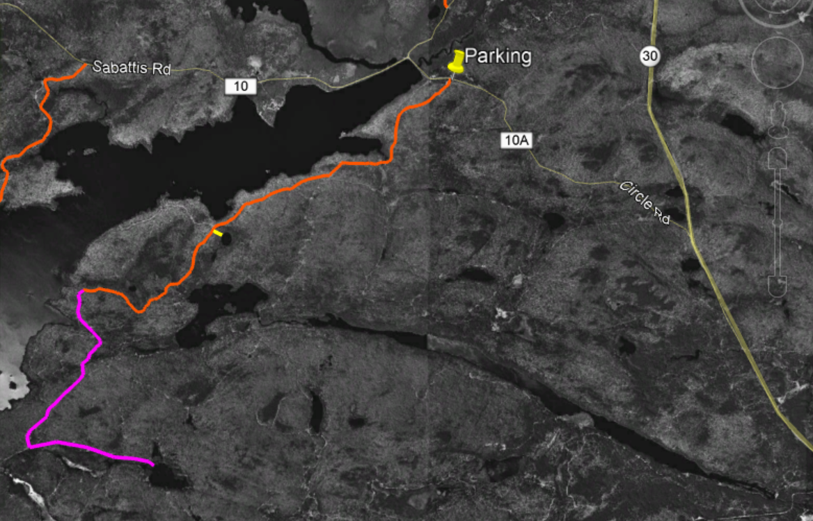
The full route shown overlaid on black and white imagery from 1994. The South Shore Horse trail is in orange. The short side trip to the unnamed pond is in Yellow. The possible extension to Doctors Pond is purple.
Beaver meadows near where the trail ends. To reach the lake pass this area on the left.
Little Tupper Lake looking southwest from a point near the end of the South Shore Trail.
I've previously written about the the network of trails that follow the northern shoreline of Little Tupper and provide access to the ponds southwest of the lake. Those routes, like the South Shore Trail, pass through, young, second growth woods. Most of the lands that make up the Whitney Wilderness were logged heavily in the years leading up to acquisition by the State and these woods will need decades to return to a pre-disturbance condition.
From another point on Little Tupper Lake, the view is towards the southwest.
While these two trail systems are in many ways similar I think that the South Shore Trail is more appealing. The South Shore route passes a series of swamps, marshes and beaver ponds all of which add interest to the route. Both routes have been blocked by beaver impoundments at multiple points, so plan on some wading at times of high water.
This small unnamed pond can be reached by bushwhacking from the trail. It appears that this pond is slowly filling in and appears to be headed for bog status in the future. Based on the vegetation that is present this is probably a good location for looking for boreal bird species.
An interesting short side trip can be made to visit a small pond that is slowly transitioning to a boreal bog. There's no trail to the pond but it's easy to find. At the 2.5 mile point the trail enters a large clearing where a small sign points out a 90 degree left turn. Just after reentering the woods a large abandoned culvert pipe can be seen left of the trail. This is a good place to head off to the east for the side trip to the pond. The pond is less than 200 yards away and can be reached in five minutes, even accounting for the blowdown and thick growth. The pond is entirely surrounded by bog vegetation: Labrador Tea, Tamarack, and insectivorous Pitcher plants.
If you are looking for something a little more adventurous, the South Shore Horse Trail could be used to set up a visit to Doctors Pond. A remote and little visited body of water lying in the southeast corner of the Wilderness. A possible route would leave the South Shore Horse Trail at an intersection where a sign --nearly lost in the encroaching forest-- says simply, "Trail". This intersection is about four miles from the parking area and just a quarter mile from Little Tupper Lake. A unmarked logging road bearing southeast from this intersection could provide the basis for such a route.
The possible route extension to Doctors Pond is represented by the purple line. This screen capture from Google Earth is overlaid on historic imagery from 1994. The many logging roads (abandoned with the state acquired the land in 1997.
After just a quarter mile this abandoned road runs into a complex of beaver ponds along the outlet stream that joins Stony Pond with Little Tupper Lake. From the point where the old road is blocked, it should be feasible to head west (towards Little Tupper Lake) to work around the wet areas. Rejoining to the old road on the far side, it appears that it could be followed for a mile to an intersection with other abandoned roads that ran from Little Tupper Lake to Doctors Pond. The total distance for this add-on is a little more than two miles and you would be wise to expect the route to be muddy with lots and lots of blowdown. Even so, following these abandoned roads is generally easier than bushwhacking.
NOTE: If you attempt a route like this you need a good map, a compass and knowledge of what you are doing. Navigating in country like this is much harder than it seems.
* The official Whitney Wilderness map produced by the NYS Department of Environmental Conservation shows this trail as the Stony Pond Trail. Not a great name given that Stony Pond is on Private Land and cannot be reached from this trail.