The South Shore Horse Trail* starts at a large parking area just east of Little Tupper Lake on the Sabattis Circle Road (Hamilton County Rte. 10A). At the rear of the parking area a sign reads simply, "South Shore Trail 4 Miles". And that pretty much describes the route. This scantily marked trail follows abandoned logging roads into the emerging wilderness south of Little Tupper Lake. I walked the route on a snowy day in early December and winter is a good season for hiking in the Whitney Wilderness. In warmer months, this trail will be wet, in-grown and buggy.
One of several beaver disturbances that must be crossed along the way. Bands of heavy lake effect snow were falling on the day of my visit.
A large beaver pond just a mile from the road. When the water level is down you can easily cross the stream. At other times the dam itself can be crossed.
There is no specific destination for this walk in the woods. Signs point the way where old logging roads intersect but, after four miles, the trail simply fades into the forest. Leaving you two hundred yards short of Little Tupper Lake. You can access the lake shore at several points along the way but, right where the trail fades, reaching the water is a messy proposition. A tangle of blowdown, thick vegetation and beaver swamps will stand between you and the shoreline.
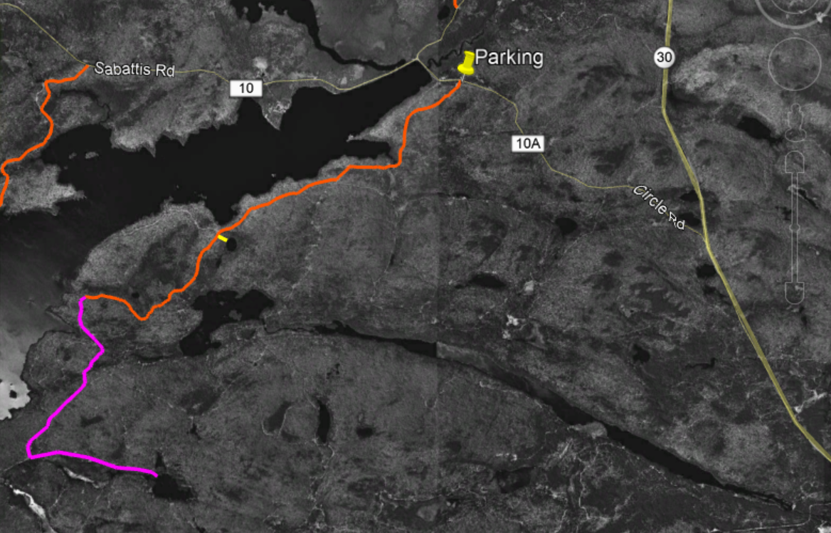
The full route shown overlaid on black and white imagery from 1994. The South Shore Horse trail is in orange. The short side trip to the unnamed pond is in Yellow. The possible extension to Doctors Pond is purple.
Beaver meadows near where the trail ends. To reach the lake pass this area on the left.
Little Tupper Lake looking southwest from a point near the end of the South Shore Trail.
I've previously written about the the network of trails that follow the northern shoreline of Little Tupper and provide access to the ponds southwest of the lake. Those routes, like the South Shore Trail, pass through, young, second growth woods. Most of the lands that make up the Whitney Wilderness were logged heavily in the years leading up to acquisition by the State and these woods will need decades to return to a pre-disturbance condition.
From another point on Little Tupper Lake, the view is towards the southwest.
While these two trail systems are in many ways similar I think that the South Shore Trail is more appealing. The South Shore route passes a series of swamps, marshes and beaver ponds all of which add interest to the route. Both routes have been blocked by beaver impoundments at multiple points, so plan on some wading at times of high water.
This small unnamed pond can be reached by bushwhacking from the trail. It appears that this pond is slowly filling in and appears to be headed for bog status in the future. Based on the vegetation that is present this is probably a good location for looking for boreal bird species.
An interesting short side trip can be made to visit a small pond that is slowly transitioning to a boreal bog. There's no trail to the pond but it's easy to find. At the 2.5 mile point the trail enters a large clearing where a small sign points out a 90 degree left turn. Just after reentering the woods a large abandoned culvert pipe can be seen left of the trail. This is a good place to head off to the east for the side trip to the pond. The pond is less than 200 yards away and can be reached in five minutes, even accounting for the blowdown and thick growth. The pond is entirely surrounded by bog vegetation: Labrador Tea, Tamarack, and insectivorous Pitcher plants.
If you are looking for something a little more adventurous, the South Shore Horse Trail could be used to set up a visit to Doctors Pond. A remote and little visited body of water lying in the southeast corner of the Wilderness. A possible route would leave the South Shore Horse Trail at an intersection where a sign --nearly lost in the encroaching forest-- says simply, "Trail". This intersection is about four miles from the parking area and just a quarter mile from Little Tupper Lake. A unmarked logging road bearing southeast from this intersection could provide the basis for such a route.
The possible route extension to Doctors Pond is represented by the purple line. This screen capture from Google Earth is overlaid on historic imagery from 1994. The many logging roads (abandoned with the state acquired the land in 1997.
After just a quarter mile this abandoned road runs into a complex of beaver ponds along the outlet stream that joins Stony Pond with Little Tupper Lake. From the point where the old road is blocked, it should be feasible to head west (towards Little Tupper Lake) to work around the wet areas. Rejoining to the old road on the far side, it appears that it could be followed for a mile to an intersection with other abandoned roads that ran from Little Tupper Lake to Doctors Pond. The total distance for this add-on is a little more than two miles and you would be wise to expect the route to be muddy with lots and lots of blowdown. Even so, following these abandoned roads is generally easier than bushwhacking.
NOTE: If you attempt a route like this you need a good map, a compass and knowledge of what you are doing. Navigating in country like this is much harder than it seems.
* The official Whitney Wilderness map produced by the NYS Department of Environmental Conservation shows this trail as the Stony Pond Trail. Not a great name given that Stony Pond is on Private Land and cannot be reached from this trail.