Saturday, March 11, 2017

Moreau Lake State Park: Wondrous Lake Bonita Trails

It was just 24 months ago that 750 acres formerly held by the now closed Mt. McGregor Correctional Facility were formally added to Moreau Lake State Park. Since then a new parking area for hikers and three new trails have been built. That's a pretty good pace for these sorts of things but what makes this a truly impressive effort is that these new trails are really well thought out. Moreau Lake State Park now offers hikes ranging from a couple of miles to a "grand loop" covering nearly 15 miles without any retracing of steps (you can bet an account of that walk will appear on this blog in the future). My most recent outing, covering nine miles, took me past two attractive lakes, over ledges and past cascades and through an attractive and varied forests. There are good view along the way of the Hudson River and the southern Adirondacks.

An overview of the Moreau Lake State Park trail system. The heavy blue line, starting at the bottom left, is the route described in this post. The other colored lines seen on the map represent other trails in the park. For scale, the route represented by the heavy blue line covers a distance of just over nine miles. The two sections closest to the bottom of the image are new trails added as part of the Lake Bonita expansion.
The newest trail leaves the Lake Bonita Loop Trail near the spillway at the north end of the lake. From there it's about 1.5 miles to a to a junction with the West Ridge Trail. At the time of this writing that junction is unmarked but the trail itself is well marked (parking is on the Corinth-Wilton Mountain Road).

The Western Ridge Trail is one of the primary access trails that lead up onto the Palmertown ridge and the Park's main trail system. The Palmertown Ridge is interesting from both geological and ecological perspectives and evidence of the last glacial period lies heavily on this landscape. It is generally believed that the ice sheets of that last glacial period retreated from this area between twelve and fifteen thousand years ago with mountain glaciers persisting into the more recent end of that range. That's a long time by human standards but not even the blink of an eye in terms of geologic time. Walking the trails on the Palmertown ridge always reminds me of this. There are many places where soil lies just a few inches thick on top of deeply scarred bedrock.

A rock outcropping along the new trail from Lake Bonita to the Western Ridge Trail.
The geology of the Palmertown ridge strikes me as being somehow different from similar landscapes in the southern Adirondacks. For example, the ridge crossed in the first couple miles of the Northville to Benson section of the Northville-Lake Placid Trail has some characteristics in common with the Palmertown Ridge. The Northville ridge is a little higher but ecologically similar; an Oak-Hemlock forest. But the landscape has a different feel. Could it be the distinction between being part of the Canadian Shield (the primary geologic formation of the Adirondacks) as opposed to rock that has been pressed up against the shield. I'm imagining that as a possibility for the Palmertown Ridge. The most likely explanation is that this is my imagination run wild. Perhaps someone with more knowledge of the geology of the region will let me know.

In any case, the terrain encountered on the Palmertown ridge is unexpectedly rugged and, according to my GPS, the total elevation gain for the route I walked was 2200 feet. There's just a single significant climb so nearly all of that elevation gain comes from the relentless ups and downs you encounter along the way.

The shore line of Lake Anne. This small, shallow, lake is ringed by an ecologically interesting marshy shoreline. 
One point of specific interest for me was a stand of spruce on the northwest shore of Lake Bonita. I had noticed the trees on my previous visit. But that was a day of our only major snow fall of the year and with darkness approaching I took no time to investigate. Still, I did notice two things:
  1. The trees were some kind of Spruce (I was not sure of what variety) 
  2. The trees looked out of place
Taking a closer look under benign conditions confirmed both points. My first impression had been that this was a stand of Norway Spruce; a widely planted import to the Adirondacks. When Norway Spruce grow in the open --as the do in various places in Saratoga Spa State Park-- they exhibit a distinctive branching pattern that makes them especially easy to identify. However, when growing close together under constrained conditions Norway Spruce can look a lot like other Spruce varieties that are native to this region. However, there is one identifying characteristic that trumps all others. Norway Spruce have long cones that are much larger than any other spruce from around these parts. These trees are Norway Spruce.

A lovely cascade crossed by the new trail section that runs from Lake Bonita to the Western Ridge Trail.

From the first overlook on the Western Ridge Trail. This popular destination is barely a mile from the parking area on Spier Falls Road. It's a bit more than 2.5 miles from the new parking area on Corinth Wilton Mountain Road. The view is of the Spier Falls reservoir on the Hudson River and the Southern Adirondacks beyond.


Lake Anne. Late Winter.

This open glade on the ridge line near the Western Ridge trail was probably open meadow just a few decades ago. The trees are Chestnut Oak. A common species on this section of the Palmertown ridge. This species somehow favors the edges of steep ridges. I'd love to more about the history of the forest on this ridge.   


Wednesday, March 1, 2017

Winter Outings 2017

Moreau Lake SP: Heavy Snow
Northville Lake Placid Trail: To the High Point
GPS Accuracy: This is what I've been talking about

Moreau Lake State Park: Heavy Snow

I have not been posting much recently because I have not been able to get out but on successive January weekends I got away for quick jaunts to visit a couple of favorite haunts. The first outing was to Moreau Lake State Park on a day when over a foot of snow fell. Over the six hours I was on the trail eight to ten inches of snow fell and by late afternoon tracks I had made in fresh snow in the morning had vanished.

Looking out from the lean-to at Lake Anne. For a time the snow was falling at a rate that accumulates several inches per hour. You might think that the video has been speed up in some way. It has not. 

The route. Note the red line leaving Lake Bonita. There looks to be a new marked trail going off in that direction. Also, my route does not follow the actual trail in several places. I tend to wander around investigating areas that catch my eye. The marked trail is easy to follow. 
It appears that the new parking area on Corinth Mountain Road will be kept plowed and open in the winter and that provides convenient access to new trails in the southern part of Moreau Lake State Park. I followed one those new trails to Lake Anne. From there a previously existing trail joins up with the Park's main trail system at junction S9 (if you are using the Park's official trail map).

The trail to Lake Anne (opened in the summer of 2016) passes through lands added to the park following the closing of the Mount MacGregor Correctional Facility. Intriguingly, on my way back to the car I followed the loop trail around Lake Bonita and it looks like another new trail has been added leaving the northern end of Lake Bonita next the spillway. If it goes where I think it might go it could make for a nice loop hike connecting with other trails that can be reached from Spier Falls Road. I'm planning to get back soon to take a look.

A Hemlock glade in winter. Snow fell heavily throughout the day.

Lake Bonita from near the trail that circles the lake. This is from the southern end of the lake looking north.

Lake Bonita again. This time from the far shore looking roughly from the east to the west.

Northville-Lake Placid Trail to the NLPT High Point

My second outing was on the Northville-Lake Placid Trail south from the Rte. 28n junction just east of Long Lake village. This trail head is less than a mile from a family home in Long Lake and I've walked this route many times. However, this outing was different. A series of storms over the previous two weeks had dropped three feet of snow which was then softened up by two days of unusual warmth (60+ in Long Lake in February? That can't be right). Higher up the snow was even deeper; three to five feet depending on the slope and the drifts.


Video from near the place where I turned back. I didn't actually make it to the highest point on the ridge turning back a quarter mile or so short of the height of land. I had passed my turn back time and the going in very deep, soft, snow was sloooow to say the least So following a quick lunch I headed back down.

The trail was partially broken to the point where the Three Brooks Ski trail joins the NLPT but past that junction no one had left a mark in the deep snow. Breaking trail while climbing makes for slow going and it took me 4 hours to cover four miles. Coming back down was a lot faster although fatigue started to counter the benefit of having a broken trail to follow. Seven hours on show shoes in deep snow is a full day. I was using a pair of lightweight snowshoes that were not very well suited to the conditions. This was one time when my larger Sherpa snow shoes would have been a better choice.

Starting out the day was bright and sunny. The Black Spruce Bog near the trail head is a consistent source of good photos and, for those interested in Adirondack ecosystems, one of the easiest places in the park to see this type of bog. Larger bogs are found to the north and west but this is one of the southernmost instances of this type.  

Near the place where the NLPT crosses Sandy Creek about a mile from the trail head.

Sandy Creek. This photo was taken the day before the hike on a short reconnaissance walk to judge conditions I would find the following day.
The Long Lake Spruce bog in early morning.


GPS Accuracy: This is what I've been talking About

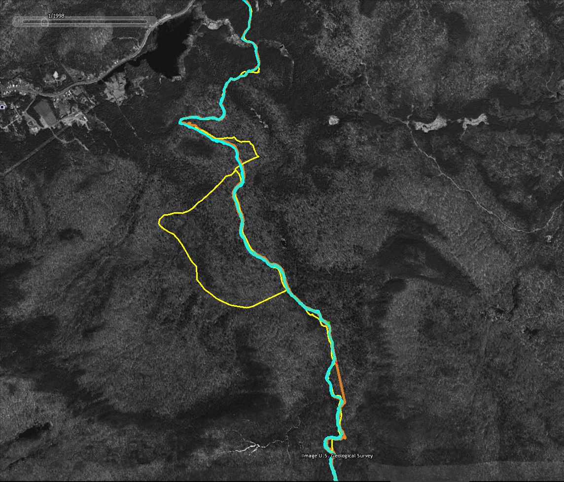
I've written about GPS accuracy in the past but nothing beats an example. The screen captures that follow (from Google Earth using historic imagery as the basemap) show how "accuracy" varies when using common GPS devices in the woods.
Legend:
  • Yellow Line: The trail as represented in the downloadable DEC Hiking Trails file. I don't know how DEC created the trails file but in many areas it shows only an approximation of route the trails actually take.
  • Cyan Line: The track captured by my Garmin GPSMap64 GPS Receiver. This was an out and back hike, so the two lines represent the trip up the mountain and return trip back down. Because I was snow shoeing in deep snow the two tracks should, in theory, overlap. I stayed in the trail I broke on the way up on the return trip.
  • Orange Line: The track captured using the GPS app on my phone. The two lines show the out and back routes as described above.
  • The Red Line is a high accuracy representation of the route. You can't see it in these images but the trail in the area shown follows an old woods road and it is possible to make out the route in the Google Earth imagery. The red line was traced from the image and should closely follow the actual route on the ground.
  • The horizontal green line; For scale, the green line represents a distance of 60 feet on the ground.


A section of the route overlaid with two sets of GPS tracks (the out and back tracks from two separate devices). The yellow line is less accurate representation from the DEC Trails download. The red line closely follows the actual route as traced from the image. 


Same as above with the less accurate tracks captured using the phone GPS hidden. The blue lines --tracks captured by a good consumer grade GPS unit-- vary by an average of 20 feet. The absolute variance from the traced representation of the trail (the red line) is also on average in 15-30 foot range. Larger variations might be the result of wandering off the trail at certain points.

For context, more of the followed route. The yellow "bulge" in the middle is a side trail off of the NLPT main route. The straight orange towards the bottom of the image is where the phone based GPS lost the GPS signal for a period of time. The straight line connects the points where the phone lost and later regained the signal.

Saturday, January 21, 2017

Northville Lake Placid Trail - Benson Re-Route - Part Three

The Northville Lake Placid Trail 'Benson Re-Route' can be thought of as having three sections. I've now walked (and written about) all three sections.
The Benson Road splits the full sixteen mile route roughly in half and the southern half is split again by the crossing of West Stony Creek. A bridge over West Stony Creek is planned but has not yet been built so walking the full route would require fording the creek. Getting across at times of high water would require some serious motivation.

In the past year I've reached the ford point from both sides. From the south in February of 2016 and from the North in January of 2017 (the subject of this post).

Four PM on a January afternoon. The four miles from the creek back to the trailhead was slow going and I got back to the car after dark. Which meant that I got to enjoy the fading light late afternoon light.

Individually, each of the three "sections" of this addition to the Northville Lake Placid Trail make for appealing day hikes. I've walked all three legs in winter though the conditions for the outings were very different. The first two trips, in February of 2016, were characterized by lots of ice and very little snow. For this most recent outing (mid-January 2017) there was an 18-24 inch snow pack and my decision to leave the snowshoes in the car became regrettable late in the day.

West Stony Creek looking upstream from the ford. A bridge is planned but has not yet been built. 

GPS Track for the section between Benson Road and West Stony Creek. Unless you are planning to ford the creek this section is walked from the parking on Benson Road south to the creek and back.
Closer look at West Stony Creek. Easy to cross in mid-summer. Not so easy when the water is high or in Winter.

Another late afternoon scene along the trail.


Monday, October 31, 2016

Burnt Bridge Pond and the Dog Pond East Leg

Burnt Bridge Pond is reached from a prominent trail head on Route 3 a few miles east of Cranberry Lake. It's 6.6 miles to the lean-to situated on a small bluff on the west shore of the pond. It's a nice spot.

The extensive marsh on the west end of Burnt Bridge Pond. From near the lean-to.

The trail to Burnt Bridge Pond is not especially compelling but the pond itself is very attractive. Looking across the pond from near the lean-to.
A portion of the route to Burnt Bridge Pond also serves as the northern leg of the 13 mile "Dog Pond Loop". That route connects several remote ponds and the western segment passes close to Cranberry Lake in several places. The trail also passes through stretches of forest that are notable for having been lightly logged if they were logged at all. In addition to visiting Burnt Bridge Pond I added a 2.5 miles side trip south on the eastern leg of the Loop (and back). This was to visit one of those old growth stands.

At three miles from the road, you reach the northwest corner of the Dog Pond Loop trail at a place known as the potato patch. Meadows at that location were once used to grow potatoes for the logging camps that dotted the region. The forest is now reclaiming the potato patch which is filling in with trees and brush. 
Starting on Rte. 3, it's three miles to reach the northwest corner of  the Dog Pond Loop trail at a place known as the Potato Patch. So that's three miles to the loop, thirteen miles around, and three miles back out. On dry summer day that might be doable, but nineteen miles seemed a bit ambitious for late October. Which makes it ironic that the route I took ended up covering 19.2 miles. That meant getting back to the car at 7:00 pm having walked the last mile or so using a flashlight.

My route (blue line) to Burnt Bridge Pond with the side trip south on the Dog Pond Loop. I followed the loop trail to the point where it passes a beaver meadow that provides the first trickle of what will become East Creek. That's also the point where the climb up to the notch between Dog and Bear mountains begins. The yellow lines are trails as delineated on Department of Conservation maps. The disconnect in the trail is where an old route encountered private land. The new trail bypasses that section. The difference in the image (brown on the upper half, green below) is because the imagery available in Google Earth is from two different times of year.
Even though continuing around the loop would have covered the same distance, it would have required a lot more effort. The Dog Pond Loop is a wilderness trail that passes through rugged country. The route to Burnt Bridge Pond is a snowmobile trail that follows an abandoned logging road so long stretches are relatively easy walking. The full dog pond loop will have to wait for another day.

Along the east side of the Dog Pond Loop

Along the east side of the Dog Pond Loop

After leaving the potato patch the trail to Burnt Bridge Pond passes through youngish second-growth hardwoods and, to be honest, this section of trail is fairly dull. The route passes a number of old logging clearings and the most interesting stretch is through a section of forest where the ground is littered with old disintegrating logs. Many of the larger trees (18-24 inch diameter) in that stretch are broken off well above the ground leaving the trees damaged but still living. Most the rotting logs are oriented on an east to northeast axis. This area clearly experienced a blow down event and given the log's state of decay it seems likely that it was the 1995 storm.

The Dog Pond loop section, south from the Burnt Brook Pond trail, is much more interesting. Less than a half mile from the junction you reach a crossing of a brook that feeds Burnt Bridge Pond from the west. That crossing exhibits what is sometimes referred to in trail guides as "extensive beaver activity." In this case meaning that the bridge over the brook is sitting in the middle of a beaver flooded area (Oct 2016). It's probably possible to find a way around the flooded area on the downstream side or you can cross one of the beaver dams. The one just above the bridge is reasonably easy to cross but doing so while keeping your feet dry will pose a significant challenge.

Flooded bridge on the Dog Pond Loop eastern leg

Upstream from the bridge the beaver flooded area is quite large.

South of the crossing the trail quickly enters mature forests that were lightly cut or, perhaps in places, not cut at all. The trail passes over a series of gentle ridges with a number of spots where the work of the glaciers is readily visible. There are old growth trees present in this section and in particular I noted the presence of old growth Hemlock. I was not really expecting to see Hemlock and the composition of this forest is different from higher elevation areas to the south and east. It appears that this would have been primarily a Beech-Maple forest with Hemlock in the wetter more sheltered places. Very few spruce are present. Maybe because conditions were not favorable or maybe becasue those were the trees cut from this area of forest.

An old growth hemlock. The ski pole is over four feet tall.


Monday, October 24, 2016

Hitchen's Pond Overlook

Calling an Adirondack hiking route a "hidden gem" is more than a little cliched. There are so many gems to choose from. That said, Hitchen's Pond Overlook --and the trail that gets you there-- is a hidden gem. You reach the trail by following Route 412 to Horseshoe Lake (from Rte. 30, south of Tupper Lake). Drive all the way around Horseshoe Lake and eventually the (now gravel) road turns sharply to the left and crosses railroad tracks. From there it's just under a mile to an intersection where a gated side road appears on the left. There are no signs or trail register to indicate that it's the right spot but there's plenty of room to park.

Hitchen's Pond Bog

Another bog passed on the way to Lows Upper Dam and the overlook.

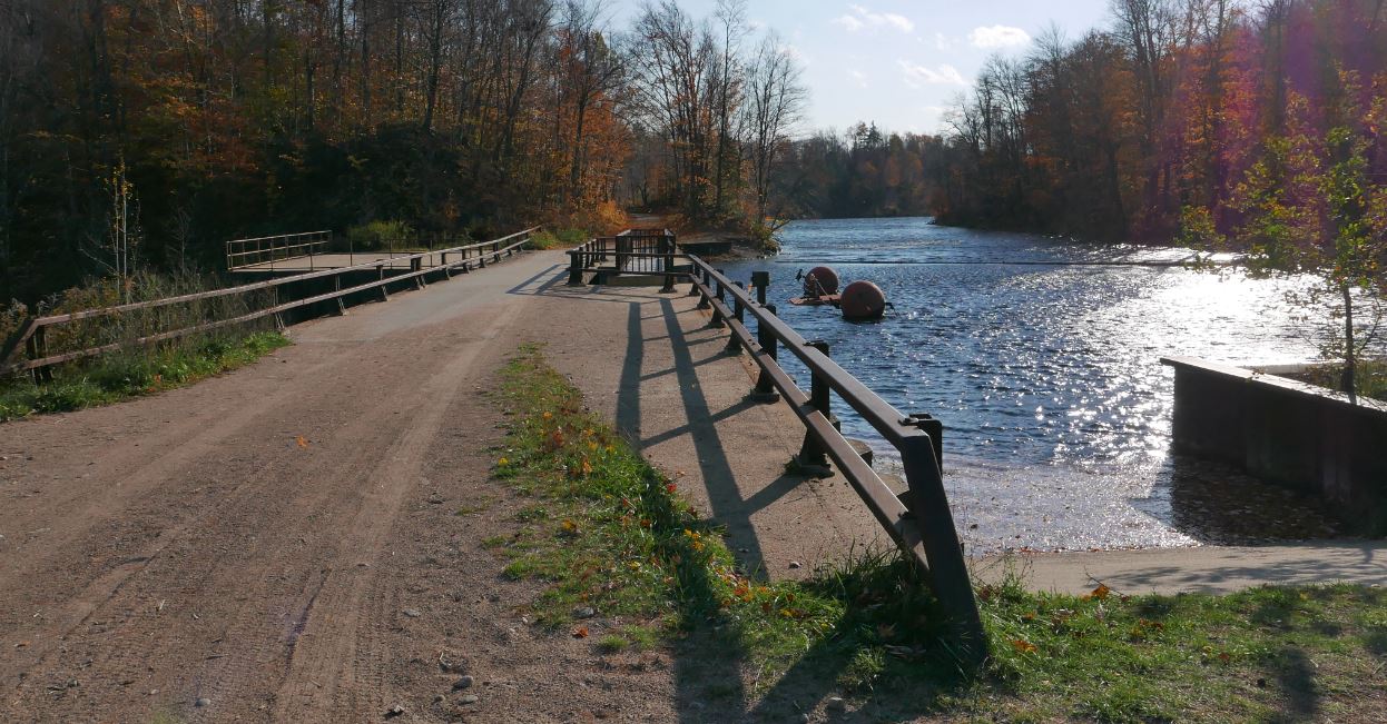
Pass the gate and you will soon see small signs indicating that you are in the forest preserve. Within a short distance you'll catch glimpses of Hitchen's Pond Bog, one of the largest in the Adirondacks. After roughly half a mile the route crosses a corner of the bog with extensive views. The road makes for easy walking and you'll pass several other places where bogs and swamps add interest to the 2.4 mile walk to Low's Upper Dam. The large concrete dam impounds the Bog River thereby turning what was once a 15 mile long series of lakes, ponds, bogs and swamps into the large body of water now known as Low's Lake.


Low's Upper Dam

The trail to the overlook leaves the dam site and ascends the obvious ridge to the north. It's a little over a mile to the open rock where the trail ends with spectacular views of the lake and bog dotted country around Hitchen's Pond. On a clear day several Adirondack ranges, including portions of the high peaks, can also be seen. I was lucky enough to visit the overlook at around 5:00 pm on a gorgeous late October day. While there the cold front that had been threatening all afternoon arrived from the west and the light breezes because a steady 25 mile per hour wind. Take a look at the video to see what I mean.


Looking southeast from the overlook

Looking east from the overlook. The center peak of the ridge of three distant summits is Kempshall Mountain near Long Lake.

Looking south from the overlook

Friday, October 21, 2016

Lost trails; Little Squaw Brook and Colvin Brook

In my previous post I wrote that I don't often return to trails I've walked before because there are so many new and interesting places left to see. Particularly because I like to pick out old trails to see if I can find and follow them. Routes that the New York State Department of Environmental Conservation (DEC) lists as "unmaintained" are my favorites. So the trail to Carry Pond and then up the valley of Little Squaw Brook would be just perfect. Plan A was to ford the Cedar River (near the Carry Lean-to), visit Carry Pond, and then follow the trail up the valley for a couple of miles. For reasons I'll get to in a minute, plan A did not happen.

South along the Northville Lake Placid Trail from Cedar River Flow. The yellow lines are trails from the DEC trail reference (KML file you can download). The blue line is my route covering about 12 miles out and back.  

Cedar River Flow. A warm, cloudy and very still mid-October day. So warm in fact that a few misquitos joined in the fun.

Heading south on the Northville Lake Placid Trail from the Moose River Recreation Area main road (Trailhead and small parking pullout located a mile south of the Cedar River Flow entrance) the route passes along the south west side of Cedar River Flow and then through an area logged in the not too distant past. The trail follows what was originally a well-built logging road and the forest is primarily second growth with several bogs and swamps thrown in to keep things interesting.

Looking west across one of several bogs crossed by the Northville Lake Placid trail south of Cedar River Flow; Manbury Mountain in the distance. 

A sphagnum moss bog passed between Cedar River Flow and the Carry Lean-to. This was taken on my return trip when a brief glimmer of sun gave hope that the heavy cloud cover might break. Five minutes later it was raining.

A little over three miles from the trailhead an abandoned woods road enters from the west and you pass iron posts that would have supported a gate. A bit further on I noticed an indistinct and unmarked trail leaving the NLPT towards the east and a minute later I reached the spur trail leading to the Carry Lean-to. Which meant that the indistinct trail just passed was the trail to the ford that would start the route to Carry Pond and Little Squaw Brook. Going back, I followed what is best described as a trace of a hint of a path down to the Cedar River. As places where you might try to ford a river go this was as unappealing a crossing as I have come to in the Adirondacks. The river at that point is slow moving and muddy providing no glimpse of the bottom so you could gauge the depth and footing. Worst of all the banks on both sides are steep and lined with thick brush. Crossing there? Not gonna happen.

Cedar River at the place where the abandoned trail to Carry Pond and the Little Squaw Brook valley crosses.

Trail signs at the junction where the short spur trail leads to the Carry Lean-to (which, based on signs on the trail has been renamed the Cedar River Lean-to).
Returning to the main trail I retraced my steps to the junction and followed the short spur to the lean-to to see if it might be possible to cross there. Though there is a landing on the near side of the river below the lean-to the basic conditions of the crossing reamined the same. Also not gonna happen. So, on to plan B. Which was to follow the main trail south to the Colvin Brook trail and follow it to the Colvin Brook lean-to.

The Colvin Brook trail is an eight mile spur that connects the NLPT with Route 30 at the Lewey Lake Campground. The route crosses a 3000 foot height of land between Lewey and Cellar Moutains. On the east side (coming from Lewey Lake) the trail is called the Sucker Brook Trail and it is an interesting and easy to follow route through stands of never logged or selectively logged hardwoods (I hiked it in 2013). On the west side, however, trail guides going back to the 90s have warned that the three mile stretch between the Cedar River and the height of land is obscure and difficult to follow. In keeping with this the DEC recently closed the trail citing extensive blowdown and beaver flooding. This is the trail that David Boomhower took in 1990 attempting to bail out on his NLPT through hike. A huge search effort failed to find him and his body was eventually discoverd a few months later by a hunter. He had made it over the height of land and was just a quarter mile from the trail. He had apparently lost his way and succumed to physical and mental exhaustion.

You'd need crampons to cross this partially collapsed bridge. It was steeply pitched and very slippery. Luckily, the water was low making it easy to bypass the bridge and rock hop across the stream.
Junction of the side trail to the Colvin Brook Lean-to and the NLPT.

From behind the Colvin Brook lean-to. This is a really attractive spot and this lean-to looks like it gets very little use.
But the mile long section of trail between the NLPT and the Colvin Brook lean-to is well marked and as attractive a forest walk as any in the Adirondacks. The route passes through maturing second growth stands of both hardwoods and softwoods including stands where large spruce and fir are present. The lean-to is on the east side of the Cedar River --so you have to cross to get to it-- but it's easy to rock hop across at times of low water. 

The river provides a really attractive setting for a lean-to which appears to be infrequently used. The Colvin Brook trail proceeds past the lean-to where it immediately enters a stand of what I took to be old growth spruce and fir. That stand contains Red Spruce with diameters over 30 inches; uncommon in a region where spruce were relentlessly pursued by loggers. I followed the trail past the lean-to for quarter mile and it is intriguing, but I had six miles to cover to return to my car and the steady drizzle was threatening to become a full-on rain. So I headed back.

Old growth spruce near the Colvin Brook lean-to.

The Colvin Brook lean-to

Cedar River looking north from the crossing at the Colvin Brook lean-to


Back at Cedar River Flow on the return trip. Lewey Mountain in the distance.