Saturday, October 18, 2014

Moreau Lake - East of the Hudson -StoneWall Trail

The Hudson River splits Moreau Lake State Park (MLSP) into two sections. The main body of the park --where Moreau Lake is located-- is west of the Hudson River. However, a good sized chunk of park lies east of the river and coming from Saratoga Springs you must cross the Hudson to get there. Confusing the issue is that the Hudson makes a 90 degree turn and flows northeast through the park. So a hiker viewing the Hudson from the Palmertown Ridge is looking west toward the section of the park that is east of the river.

Moreau Lake State Park; The eastern section is on the left in this image of the park trail map.
To reach this eastern section of the park from Saratoga Springs take route 9N to Corinth. Cross the river and drive north for a half mile to the intersection with Call Street.  Turn right onto Call Street. About three miles from that intersection you'll see Hawk Road on the right (one sign says Hawk Street but it is Hawk Road). The first half mile of Hawk Road is paved but you'll quickly reach a steel gate where a sign reads; "Trailhead Parking Straight Ahead". From there it's about a mile on a one lane dirt road to the large parking area. As of October 2014 the road was passable for normal passenger cars with just a couple of rough spots.

The Stonewall trail --with Blue Markers-- leaves the west side of the parking lot (on your right as you drive into the lot). A second blue marked trail leaves the lot on the opposite northeast side. That trail is not seen on park maps that I have but it's a nice addition to the trail system. It makes possible a very pleasant loop hike of about 2.5 miles. The far point of the loop is near the Hudson at a spot where some 19th century building foundations remain. Making the "loop" is a bit confusing because, as mentioned, not all of the trails appear on the current trail maps. Even so, it's easy country to navigate and the continuation of Hawk Road (abandoned) crosses the trail at a couple of points making it possible to return to the parking area by that route.

Through the trees - the Spier Falls reservoir (Hudson River) 
This "Hawk Road Trail" (a name I just made up) also reaches the Hudson; but at a point further downstream just above the Spier Falls dam. From there the trail/road continues to the power line right-of-way leaving the power station at Spier Falls. The trail runs along the right-of-way as part of the canoe portage route around the Spier Falls dam. Canoeists approaching the dam from above leave the water and climb up to the road, follow a short stretch to Hawk Road to the right of way, and return to the water walking downhill under the power line. At that point you are on the upper section of a second reservoir backed up behind the Sherman Island dam about 3 miles further downstream. The hiking trail continues along the east bank of this reservoir for a couple more miles, but the transition between the two sections is heavily overgrown and serious tick precautions will be needed to get through unscathed.

Also worth mentioning is that this entire area is open to hunting and I ran into two hunters on my recent outing there. They politely handled their guns in a way that was safety aware but you should wear bright colors if you hike during hunting season.

As with the better known trails on the west side of the river, these trails offer a wealth of natural and human history to consider as you walk. I got a clear look at a male Red Bellied Woodpecker (Melanerpes carolinus). This species is distinctive and common in many eastern forests, but MLSP is a bit north of its' historic range. Which begs the question of whether this species is expanding its' range northward. And if so, why? Birds are able to respond to changing environmental conditions at a faster rate than many animals and plants (flying comes in real handy). So shifts in bird ranges can serve as an early indicator of changing ecological conditions. If the normal range of the Red Bellied Woodpecker is shifting northward it could be in response to a warming climate. But to make that assertion we need to know the natural history of this species for this area. Has the Red Bellied Woodpecker been present here in the past? If not, when did it arrive and what environmental/ecological changes make the area attractive now?

A less positive indicator of changing environmental conditions is seen in the extensive infestations of Asiatic Bittersweet (AB) along the section of Hawk Road that runs above Spier Falls dam. That AB is present here is hardly surprising. I had previously spotted AB from my canoe; at a place along the river/reservoir bank just below this section of trail. This area has been extensively altered by human activity and once it is present AB thrives where people disturb the forest and create forest edges. AB is common along a half mile stretch of the old road above the dam but I did not spot in the wilder forest areas. It would be interesting to survey the surrounding forest to determine the extent to which it has spread.
Asiatic Bittersweet along the (abandoned) section of Hawk Road near Spier Falls Dam.
Asiatic Bittersweet grows in dense stands that crowd out other vegetation and its' bulk can pull down trees. There is a similar native species; American Bittersweet. The two are easy to tell apart in the fall when the berries are present. If the berries grow all along a stem, it is the Asiatic variety. American Bittersweet has berries only at the ends of stems. Complicating matters is that the two varieties hybridize easily.
To round out my recent day of hiking I took a bush-whacking side excursion from the Hawk Road parking area down to the point where Bennie Brook flows into the Hudson (about 3/4 of a mile). Two things stand out from this little adventure. First, don't try to walk along the edge of the reservoir. It is really tough going and the dreaded deer (black legged) ticks --that carry Lyme disease-- are definitely present. The second point is that I did find something interesting along way; a very large White Oak, diameter 47 inches at chest height. This is probably the largest tree (by this measure) that I've seen anywhere in Moreau Lake State Park. And, because White Oaks are long lived, it could be the oldest as well. White Oaks can live to be 300+ years old and I'd love to know if this tree is really old, having somehow escaped logging, fires and other mishaps. Or is it a younger tree, maybe in the 150 year range, that just happened to grow under particularly favorable conditions. So many questions so little time.

Thursday, October 2, 2014

Moreau Lake State Park: A Little Known Gem

I've been fond of hiking for a long time and I've acquired more than a few trail guides along the way. Which has led me to wonder whether the authors of these guides ever regret giving the world directions to their favorite places (assuming that their favorite places are actually included in their books). It’s with this thought in mind that I start this post by saying that the hiking trails of Moreau Lake State Park are a hidden gem.

Moreau Lake State Park (MLSP) is well known to locals as a place for swimming and camping but I’d not given it much thought as a hiking destination. I knew that the park had been expanded in recent years, and a friend had mentioned that the trails were interesting, but it was canoeing on the Hudson River above the Spier Falls Dam that led to my "discovery". There are a series of dams on the Hudson between Corinth and Glens Falls and the reservoir behind the Spier Falls Dam is a favorite place for an afternoon outing. From the water you can’t help but notice the forested ridge rising above the east bank of the river. The ridge is is part of a range of Adirondack mountains known historically as the Palmertown Range. I finally got out for a solid hike in the park in late July (2014) and I've since been back a half dozen times.

You can start your outings in MLSP near the lake (there is an entrance fee for the picnicking and swimming area) but the trails accessible from Spier Falls Road provide a quieter (and free) place to start. There are three official trail-heads, and numerous bushwhacking options, but all options begin with a climb of 500-800 feet to the top of the ridge. The "ridge" is actually a small plateau roughly four miles long and a mile across (the entire park covers over 4000 acres). Once on top there are numerous trails to choose from; anything from a short loop taking in a couple of views (2-3 miles) to a grand tour covering 8 or more miles. Obtaining a map of the park trails is recommended. The trails are well marked but the intersections can be confusing and there are few signs to guide your way.

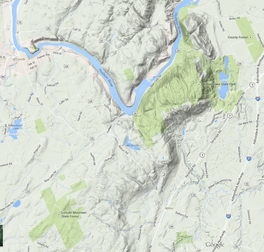
moreau_lake_topography.JPG
Image from Google Maps showing the location and terrain of the Park. The park includes significant areas northwest of the Hudson not represented in this map as public land (the light green shade) .
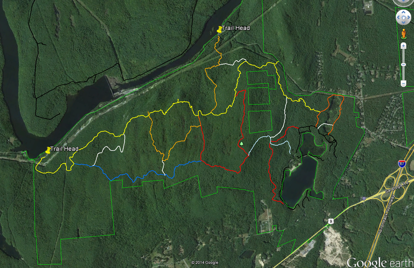
moreau_lake_trails.PNG
Image from Google Earth showing the trails
Some maps name this section of the ridge Grant Mountain but it would take some searching to find the summit. The ridge top area lies at an elevation of between 1000 and 1250 feet with numerous steep sided glacial cuts and small rocky ridges imparting an unexpected ruggedness to the terrain. Examination of a topographic map of the area shows that the Palmertown Range is part of the of the larger Adirondack uplift. Grant Mountain is defined by a glacial cirque and escarpment on the east side and by the gorge cut by the Hudson River on the west. You can see this clearly using the “terrain” (topographic) view in Google Maps (https://goo.gl/maps/AOaPa).

The map above (from Google Earth) shows the Moreau Lake State Park trail system with two of the west side trail-heads marked. As a point of reference, Northway (I-87) exit 17 is seen on the right side of the map. Spier Falls Road runs along the Hudson River between the two marked trail heads and a 3rd trail-head is found where the yellow trail intersects the green park boundary line in the upper right part of the image. Spier Falls Dam creates the prominent widening of Hudson in the center left of the image. The colored lines show most (but not all) of the trails in MLSP and you can download the trails file from the park website. The file is in the KML format that can be opened using Google Earth. To get some idea of the scale, from the trail-head marker on the left to the point where yellow joins orange on the right is about 4.5 miles.

There are several places along the yellow trail with good views of the Hudson River and the southeastern Adirondacks and an excellent view of Moreau Lake (and east toward Vermont) can be had at the point where the red trail joins the light blue trail. But the views are just icing for me; the ridge top area holds an intriguing and attractive landscape. The terrain is varied and it is overlaid with a matrix of past human activities and the effects of those activities. Much of the forest appears to be 100 year old (approximately) second growth but the effects of more recent logging or fire are seen in some areas. A few abandoned carriage roads can be found but I've seen no sign of pastures or structures.

The most common ecological communities of the ridge top area are the Appalachian Oak-Pine, Beech-Maple and Hemlock Northern Hardwood Forest types. At smaller scales perhaps a half-dozen additional community types present (see the notes at the end). Interesting, from an ecological perspective is that the central section is poorly drained with numerous small marshes and seasonal wet spots. These wet areas are interspersed with dry, rocky, ridges -with thin soil- where Chestnut Oaks are the dominant tree species. This combination is found around the edges of the Adirondacks uplands but it is uncommon in the interior of the range.

Over the coming weeks I'll add posts describing the natural and environmental history of this fascinating area but for now some photos will have to suffice.

Fungus seen along the trail. If anyone can ID this please leave a comment.

The Hudson just north of the Spier Falls Dam. The boat launch is located at roughly the lower left corner of the picture.

A small marsh.

Moreau Lake and the view looking east.

Looking northwest from a view point on the yellow trail.

Looking west across the southern Adirondacks; also from the yellow trail.

Spier Falls Dam on the Hudson seen from a view point on the yellow trail.

1.Ecological Communities of New York State (Edinger et al. 2014) - The definitive guide to ecological communities in New York State from the New York State Department of Environmental Conservation web site. http://www.dec.ny.gov/animals/97703.html

2. Moreau Lake State Park Master Plan Chapter Two The Moreau Lake State Park Master Plan (from the Office of Parks and Recreation) contains a detailed assessment of the the natural heritage of the park. The entire plan (comprised of several chapters) can be found on the park website.


Thursday, August 7, 2014

A Busy Summer of Hikes and Water Trips - Kayaderosseras Creek and Cedar River Flow

One of the worst things you can do with a blog is to allow months to go by without posting anything new. That, unfortunately, is exactly what I've done. It's not that I've lost interest in the projects described in earlier posts. It's that summers are short in this neck of the woods and I've been getting out a lot. Many of those outings have been related to the project (at least that's what I tell myself) but some have been just for fun. This leaves less time for writing then I have in the winter (winter is coming!). But setting this aside, I'll return with a a recap of a couple of recent outings.

For starters I purchased a small kayak. Elle and I have a canoe but it's a two person boat and I often end up going solo. It's an inexpensive kayak -a Perception Sport- great for noodling around. I've been out on Cedar River Flow, the Hudson River and the Kayaderosseras Creek. It's not a boat I'd use for whitewater or on a big lake if the wind was blowing but it's great for low-key day trips.

A point worth noting is the need to clean your boat before moving it among different bodies of water. My first outings in the kayak were on the Kayaderosseras Creek -a lowland creek in Saratoga County. I then put the boat on the Cedar River Flow in the central Adirondacks. To prevent the inadvertent spread of aquatic invasive species I cleaned the kayak thoroughly between those outings. New York State now requires that boats be cleaned before entry into many bodies of water and the State has created an enforcement and education program. You can learn more about it here. Take this seriously. There are several aquatic invasives that, once they gain a foothold, cause immense damage and are nearly impossible to get rid. Keeping them out is the only real solution.

A family of Common Mergansers on the Kayaderosseras Creek near Grey's Crossing (early July 2014). Severe bank erosion is common along the lower Kayaderosseras. Also common are invasive plants such as Japanese Knotweed. A local group --Friends of the Kayaderosseras-- are attempting to control the spread of Knotweed. A couple of methods have been tried but Knotweed is really really hard to kill. A recent post to the group's website details plans to simply cut the Knotweed down repeatedly until its' root energy stores are exhausted (or they are).

Issues aside, the Kayaderosseras from Grey's Crossing to Saratoga Lake has a surprisingly wild feel. Bird life is abundant and at appropriate water levels it's a fun, easy, paddle.  

The Driscoll Road launch site. The water level pictured here is ideal for a relaxed float downstream with enough flow that you don't have to get out and pull through shallow sections. Care is needed during wet weather. The Kayaderossas drains a large watershed and it can rise quickly to levels that are much less relaxed. For several miles below Grey's Crossing the route pass through Saratoga Spa State Park (on one or both sides). The site pictured here is an official launch site on state land with Parking on Driscoll Road. This site requires some effort to get down to the water and a carry of a couple of hundred yards from the parking lot but otherwise this is a good put in or take out point.  

Japanese Knotweed (Fallopia japonica) on the bank of the Kayaderosseras Creek.  

Cedar River Flow

Cedar River Flow is large lake formed by a dam on the Cedar River. The main body of the flow is over three miles long with numerous  bays and extensive wild marshes. Boats with motors are allowed but the launch is suitable only for boats you can carry or wheel to the water by hand (limiting the size of both the boats and their motors). Mostly it's a canoe and kayak paradise. The far end (the south end) of the Flow features extensive marshes where the Cedar River flow into the lake. You can paddle up the Cedar River for several miles (or many miles for the more determined) and the hardest part is finding the actual river channel through the marsh.

In late June (2014) I watched two Osprey pull fish out of the lake. Osprey are pretty common in the Adirondacks and when you see them they are a large and impressive bird. On this day a Bald Eagle flew in to check out the fishing and I was able to see the Osprey and the Eagle in flight within a couple of hundred yards of each other. From this I learned from that Bald Eagles are really big birds. The Eagle's wingspan is only a little larger than an Osprey but the Eagle is a much larger and heavier bird. In general, Cedar River Flow is a great place to view Adirondack birds. Along with the Osprey and the Eagle there were Loons, Waxwings, an American Bittern, Great Blue Herons, Canada Geese (nesting), Turkey's (on the road in) and many other common birds.

An absolutely gorgeous day. Late June 2014.

Beaver Dam on Payne Brook. A second source of inflow into Cedar River Flow

At the upper end of the lake I navigated up a narrow channel thinking it was the Cedar River. It was a dead end but worth the trip anyway.

The view from a well used (and probably illegal) camping spot that sits on a small knoll above the Cedar River.  

Leanto on the Cedar River. About 1.5 miles upstream from where the river flows into the lake. 

The river past the leanto leads deeper into the Moose River Plains. The "plains" are a glacial out wash zone characterized by sandy soils and relatively raw glacial features. The Cedar River has a mostly sandy bottom and it cuts through small ridges where only a foot or two of top soil overlay extensive deposits of sand and gravel.


Monday, April 21, 2014

Little Hoover Dam

Elle and I got out yesterday for a few hours of walking in Lincoln Mountain State Forest. This area is less than 30 minutes from our home and it's both bigger (1000 acres) and wilder than the Hemlock Forest (though it is equally wet and swampy). Lincoln "Mountain" is a bit of a misnomer. The mountain tops out at 1000 feet and it's really just a bump on the Adirondack upslope that lies to the northwest of Saratoga Springs.

The area is crisscrossed with old roads and stone walls and 100 years ago most of it would have been cleared of trees and in active use for various types of agriculture. There are a few places where the trees appear to be older; protected we guess by the general swampiness of the area. There are several small swampy ponds in the area, and seen yesterday (4/20/2014), one was looking particularly pond like (Image One). Image Two, a screen capture of Google Earth imagery from July 2013, shows the swamp with very little open water.

Image One

Image Two

One of our favorite places at Lincoln Mountain is the outlet of this pond/swamp. The main outlet flows from the lower right in Image Two. We walked over to take a look and found just a trickle of water. That seemed odd. Following it upstream for a short distance revealed the reason; one of the larger beaver dams that I've seen. It's difficult to convey the extent of this dam in pictures and I highlighted the "face" of the dam in Image Four. The dam is at least 75 feet long and 4 to 5 feet high in the center. 

Image 5 shows the water backed up behind the dam. The striking thing about this dam is its' height. The dam is four to five feet high in the center. Also, this dam is not the porous structure that you commonly see. Very little water is flowing through the dam. This is clearly a multi-year effort and it could even be multi-generational. As of April 2014 the dam looks pretty solid, but, there's a lot of water backed up behind it and if it were to fail all at once a lot of water going somewhere in a hurry.

 Large beaver dam

The face of the dam is highlighted in yellow


Water backed up behind the dam


Monday, April 7, 2014

Spring, Robins and Oriental Bittersweet

Got out into the forest yesterday (April 6) and the end of a long cold winter is finally here. I had not walked in the forest for a couple of months so I was out just to enjoy the "spring like" conditions (48f with a brisk breeze; snow and ice remaining where ever it has shelter from the sun). Happily, as often happens, I noticed two interesting things during this stroll.

The first was watching Robins feeding on the berries of Oriental Bittersweet. If you've read any of my other posts you know that Oriental Bittersweet has had visible effects on the forest in these here parts and during yesterday's walk I saw an effect I had not previously considered. As I walked I was checking birds to see what species were about on an early spring day and I notice that a group of American Robins were feeding on Oriental Bittersweet berries.

Robins' eating berries is hardly news. My Peterson Eastern Birds guide even notes this as a common "winter" behavior. But, the thing is, Robins were prominently present in Saratoga Springs throughout the winter this year and it was a very tough winter. I saw Robins near my house all winter long and, for much of the winter, a group of 10 or so roosted a large Yew bush just outside my back door. The bush had acquired a canopy of ice and snow which apparently provided some shelter from the wind and cold. I also saw Robins outside my office window (on the other side of town) throughout the winter; usually in a cluster of ornamental crab apple trees.

My Perterson Guides (one from the 50s and a 4th Edition published in 1980) both show Saratoga Springs as outside of the Robin winter range (though only by 100 miles or so). So the question is; does the presence of overwintering Robins represent an extension of their winter range or is it more a case the representation seen in these books being off by what at the scale of the maps is is small amount? The bonus question is, assuming that Robins are extending their winter range, what role are non-native plant species playing in this development? Oriental Bittersweet is present in significant quantities throughout the city as are other non-native trees and shrubs (ornamentals) that bear fruits and berries. Have these human alterations allowed the Robin to extend its' winter range by providing additional food sources? This is a specific example of the larger questions I have about the role humans are playing in altering ecological communities at regional scales.

Flooded hardwood forest area at the south end of the Hemlock Forest; April 6th, 2014

The second "interesting" thing I noted was related to my absolute favorite species present in the Hemlock Forest. As I walked into the woods I wondered if Deer Ticks (Black Legged Ticks) would be active at this point in early spring. I commonly take precautions against ticks such as spraying my pants with tick repellent but I left the house without thinking about ticks. This seemed safe if only because the grasses and plants where they tend to wait for potential meals are mostly still frozen or semi-frozen. However, habits being what they are I periodically checked my clothes for unwanted guests. Nearing the end of the walk I noticed a small black spot on my pant leg. Thinking that it was probably dirt I picked it off and lo and behold it started scurrying across my finger tip. Spring is really here. The Deer Ticks are on the prowl.


Saturday, March 1, 2014

My First TriCorder

It's not quite a tricorder, yet, at least not as I remember them from Star Trek. But the smartphone in my pocket is an amazing device and the "possible" is evolving and expanding at a fantastic rate. I'm convinced that the combination of GPS, sensors and recording technologies into common devices will change the way we learn about our world.

A few months ago I wrote about the accuracy of the four GPS capable devices I had access to. The results of those tests can be found here. Not surprisingly I found that my two hand-held GPS units were significantly more accurate than the smartphone I was using at that time. Especially when the GPS handhelds were given a minute to average out accuracy limiting discrepancies that are inherent in the global positioning system.

I recently upgraded my phone to a Google Nexus 5 - a top of the line Android-based smartphone. Informal tests of the GPS capabilities of this phone show it to be as good or better than my GPS handhelds. The phone consistently produces results that are accurate in the 3 to 5 meter range. That's the standard for uncorrected GPS and more accurate fixes require correction and averaging of some kind. Previous generations of smartphones did not generally apply these corrections but it appears that the newest ones do. In short, my new phone consistently out performs all the other GPS devices I've previously used including the dedicated GPS handhelds.

But it's really the full range of capabilities that the phone incorporates, and the potential for those capabilities to be integrated, that makes this so exciting and intriguing. Michael Goodchild wrote about the potential of "citizens as sensors" in 2007. He identified several roadblocks to the usefulness of citizen sensors that mostly come down to questions of reliability. For research purposes accuracy is important, but the ability to quantify the level of accuracy is essential. Smartphones can record the data you want to get as well as data that says how accurate the data should be. Several of the GPS apps for my phone show the accuracy of the fix in real time and you can watch the accuracy change in response to satellites going in and out of view.

This blog and the Hemlock Forest research project are coalescing around this idea of "citizen sensoring". It's also March 1st today so the end of this colder than average winter is in sight or, at least, that's the thought we keep in mind to retain our sanity. Spring IS coming and I need to prepare for the spring-time phase of my project field work.

Citizen Sensor resources include:
Academic Biology and its Discontents
Citizen Sensors Improve World Health
Smart Citizen Fab Lab <== open source sensor hardware
Smart Citizen KickStarter
More on open source sensor kits

Citizen Science Data Management Guide


This Post: Resources and References
Goodchild, M.F. (2007). "Citizens as sensors: the world of volunteered geography". GeoJournal 69 (4): 211–221. doi:10.1007/s10708-007-9111-y
GPS Accuracy Comparison (http://dataliterate.blogspot.com/2013/11/gps-accuracy.html)


Friday, January 10, 2014

Spatial Data: Pattern and Process

The topic for this post comes from an article I've just read titled; Data Science and Prediction. In the article Vassant Dhar provides a brief overview of data science and new thinking about the relationship between theory and evidence. Dhar states the idea nicely saying that data science is different because it rests on the premise that the data can reveal the interesting questions. Traditional data analysis works the other way around starting with theory and looking to data for evidence to support or dispute the theory. Data science look for patterns in data and then ask if there are interesting questions those patterns might answer. This approach is not entirely new. The history of science is full of stories where an unexpected pattern in data led to new discoveries. What is new is that we now have a lot more data to analyze. Anyway, it's a good article, well worth reading.

The broad topics discussed in the article; data science and "big data" are of great interest to me. In fact, these topics are the central themes of my other blog. That's right, I have a second blog and it is called Pattern and Process.

Pattern and Process can into being first and it is intended for a different audience. Still, if you are reading this you might find it interesting. It's all about the technical issues and concerns that go along with research methods designed to find patterns in data; especially data that has a geographic or spatial context.

While I'm on the topic of influences and resources, I've also been reading In Search of Swampland by Ralph Tiner. This book provides a surprisingly readable introduction to the hydrology and biology of swamps (let's be honest, it's not the most exciting of topics). Central to the discussion is that swamps come in many
In Search of Swampland - Cover Illustration

different varieties. This led the broad use of the term wetland to categorize lands where the presence of water changes both the form and the function of the place. This would be one of those rather dry academic subjects if it weren't for the regulatory protection of wetlands by governments at various levels. I'm sure I'll return to this topic at some point, there are marked wetlands in various parts of the Hemlock Forest, but for now the book is highly recommended.

One more book that will provide insight into the topic(s) of this blog is Forest Forensics, A Field Guide to Reading the Forested Landscape by Tom Wessels. Read this book and a walk through a forest in the northeastern United States will never be the same. Many forested areas in the northeastern U.S. were cleared land in the middle of the 1800s. This book helps you recognize and interpret clues that can tell the history of of how the land was used in the past and when that use was abandoned.


References:
Dhar Vassant, Data Science and Prediction, Communications of the ACM, 12/2013, Vol. 56 No. 12

Pattern and Process ( http://dataliterate.blogspot.com/ )

Tiner, Ralph; In Search of Swampland, Second Edition; Rutgers University Press, 2005

Wessels, Tom; Forest Forensics, A Field Guide to Reading Forested Landscapes, Countryman Press; September 20, 2010

Friday, December 27, 2013

Swamps I have Known

I like swamps. I must be easily amused. Or maybe it's oddly amused. Either way, it must come with getting older because I don't remember thinking this way when I was younger. One of the reasons that I like the Hemlock Forest is that the area contains several different wetland types. Still, when you come right down to it those areas are pretty similar. So along with the swamps and bogs of the Hemlock Forest I've been visiting a larger (and wilder) swamp found in the central Adirondacks just east of Long Lake - what I call the Shaw Pond Swamp (not sure if there is a more official name). I've also made a couple of trips to Lincoln Mountain State forest just outside of Saratoga Springs. The Lincoln Mountain forest covers about 1000 acres and it contains a less common swamp ecosystem; a red-maple black-gum swamp. I'll be writing more about these areas in future posts but for now some photos will have to suffice.

Dec. 24th 2013 near the margin of the Shaw Pond Swamp.


The area includes Shaw Pond, which is not far being a swamp itself.  The "swamp" includes a progression of bogs and swamp habitats of various types. View the Map in Google Maps.

The USGS Togopgraphic map of the area names Shaw Pond and Shaw Brook. Access is from the trail leaving NY Route 28 just east of Long Lake. This is the Northville-Lake Placid Trail so the trail goes both north and south from the parking lot. The swamp is a quarter mile south of the parking area.

Early winter is a good time to explore Adirondack wetlands.


The open swamp is visible here through the trees. There is a large area of flooded forest. (12/24/2013)

Back at home, looking at photos and working from memory I've been trying to figure out what kind of swamp this is. I think that it is a Larch Swamp but I need to go back and verify that. The value of taking good notes cannot be overemphasized.

Beaver are rarely faulted for a lack of ambition. Beaver have damned Shaw Brook just below the bridge the NTP crossing. As of Dec. 2013 the bridge is passable. That won't be the case if the water backs up much further.

Same area, the day before the dusting of snow seen in the photos above (12/23/13).

Same area in October of 2013.


Lincoln Mountain State Forest


Lincoln Mountain State Forest from Google Earth

One of several boggy ponds at Lincoln Mountain State Forest


A boggy flooded forest at Lincoln Mountain State Forest


The same swampy area as above from a different vantage point


Sunday, December 8, 2013

Data: Bittersweet

You can't talk about invasive plant species in this part of New York State and not talk about Asiatic Bittersweet (AB). This vine is one of the most visible and damaging of the invasive species found in the Hemlock Forest. I know a little more about the specifics of this plant because about 10 years ago it appeared in my backyard. I've been battling it there ever since. I cut it off at the ground and I pull it out by the roots. I've fought AB to a draw in my yard but it is everywhere in the surrounding area; especially in a successional field near my house where it has pulled down several trees by the sheer weight of the vines. AB spreads both by the dispersal of seeds by birds (that eat the berries) and via rhizomes that spread out from every established vine. This plant is not going away anytime soon.

Image One: A dense cluster of Asiatic Bittersweet vines in the Hemlock Forest.

Asiatic Bittersweet is not a shy plant and even in a dense forest spotting the vine is easy. It wraps itself tightly around the trunks of trunks of trees and it will bridge from tree to tree in the canopy. But it is in the late fall and winter that AB really stands out. Mature plants produce large quantities of orange-red berries with yellow sheaths that are quite distinctive. The only plant you might confuse it with is its native cousin, American Bittersweet. Asiatic Bittersweet hybridizes with the native variety and by all accounts the hybrid is quickly replacing the native version everywhere that both species are present. Unfortunately, the hybrids appear to take on the negative characteristics of the invader. Namely, it's ability to produce a mass of vines that tend to strangle whatever it gets a hold of. The native variety is certainly not extinct, so before you take actions to control this plant be sure you know which one you are looking at. The plants are very similar in appearance with one easily spotted distinction. When berries are present, if the berries are found all along the vine it is Asiatic Bittersweet. The berries of the native variety appear only at the very ends of each vine.

AB will be one of the plants I focus on in studying the invasive species present in the Hemlock Forest. The general questions I've discussed in other posts certainly apply and, in the case of AB, there is the additional issue of why the non-native variety is so much more destructive than the native species. In the Hemlock Forest AB is found pretty much everywhere there is an opening in the canopy. There are several old fields in various stages of succession in the forest and AB is present in all of them. It is almost certainly present in other places in the forest as well and one of my first goals will be to map the full extent of its' presence. That data can be used in the future to learn more about how AB disperses. AB can also be used to study how community assemblages are changed by a well established and aggressive invasive species.

Map One: The purple polygons show areas where Asiatic Bittersweet is present in significant quantities. This highly aggressive vine is probably found in other parts of the forest but I have not yet specifically mapped its' presence.


References and Resources:
Asiatic Bittersweet (Wikipedia)
Mistaken Identity: Invasive Plants and their Native Look-alikes

Saturday, December 7, 2013

Base Maps

In earlier posts I introduced the Hemlock Forest area and I talked about why I want to understand how ecological communities are changed when non-native species become fully established (look back at those previous posts for the details). I've also said that anyone with motivation can acquire and contribute valuable scientific data. What I have not talked about is what data you might get and how you might get it. The what and how will vary based on your interests but the thing I can do is to describe my project in detail. If you extrapolate from there.

As for the "what" you have to start with a question; something that interests you. I want to understand how non-native species alter existing ecological communities and species assemblages. My thinking is that in many cases these aggressive non-native species are not going away. They are here to stay. So, at what point do the invaders alter previously existing communities to an extent that a new community type is present. Most importantly, are those new assemblages of species more or less fit in terms of their capacity to provide ecological services and to resist future disruptions. It's commonly held that the general reason invasive species are so successful is that predators and pathogens that co-evolved with the invader are not present in a new locale. That is certainly part of the story but I wonder if some species are in effect "generalists" able to dominate where ever they are found. Take Japanese Knotweed for example. Once established, you can repeatedly mow a stand of Japanese Knotweed off at the ground for several years running and it will grow back with vigor as soon as you stop. And, if you are not paying attention, it will spread to surrounding un-mowed areas via rhizomes. Eventually you can kill it by depleting the energy reserves present in the roots, but Japanese Knotweed is one tough plant. Human activities have increased the speed at which plants like Japanese Knotweed are dispersed but it seems possible that this plant has evolved strategies that would allow it to spread far and wide on its own. We need to better understand how these aggressive generalist species operate because it seems likely that they will eventually be present globally where ever there is suitable habitat.

Back to the project, the first thing I want to know is which communities are present and where they are located. This is the easy part for me because my interest in this has emerged from working with geographic information systems (GIS). A GIS allows you to place your data into a geographic context. Using a GIS you can visually look for patterns in the distribution of the phenomena of interest. Going further, there are a wide variety of analysis techniques you can use to learn more about the phenomena as represented by your particular set of data. In short, I am starting the project with the creation of a GIS.

The first thing you need are base maps. As a term, "base-maps" doesn't have a distinctly defined meaning. It refers to whatever map layers are needed to put your data into a geographic context. These days we can download a wide variety of base-map layers from the Internet. Believe me, it didn't used to be that easy. And, if you are working outside of the United States, it might still be a major undertaking to get the base-map layers that you need. For my project I'm starting with a raster base-map layer created from a USGS topographic map. The USGS refers to these as digital raster graphics or DRGs. I'll be writing about where you can get map layers of various types in future posts but, for now I'll let the images tell the story.

A digital raster graphic (DRG) base layer showing the hemlock forest. The red line delineates the boundary of the land that is included in the Saratoga Spa State Park. The orange line shows the marked trails coming from the parking area on Crescent street (upper right in the image). Notice that in the lower left portion of the image the red boundary line does not follow the boundary visible in the underlying DRG. The boundary line was digitized from a map of the State Park and there is a slight discrepancy between the two sources. This could be the result of the two sources using different surveys or it could be a cartographic discrepancy coming from differences in the scale and accuracy represented by the two different sources.

I have also acquired aerial imagery of the Hemlock Forest Area; orthoimagery made available for public use by the New York State GIS Clearinghouse (see the Mystery Lines post for more information on this imagery source). The images are geo-registered and line up pretty well with the underlying topographic map layer. My data will be layered on top of the background provided by the DRG and the orthoimagery and I've started by creating a layer containing the park boundary and the state maintained trails present in the forest.


Image Two: The Hemlock Forest aerial image base layer with park boundary (red) and trails (orange) superimposed. Many details emerge from this view of the forest. For one, the old growth hemlocks that provide the area's namesake are easily seen clustered in the area circled by the upper trail loop.   

My interest is in ecological communities so I need to know what communities are present and where they are located. That information is available in a map published along with the Spa State Park Master Plan released in 2009. The ecological communities map is provided as an image in a PDF file. You can't add this PDF to the GIS directly but I was able to take the image and register it with the base maps in my GIS. I'll document the process used to do that in a future post but images three and four show the results A key feature of the GIS software is that it allows you to control the level of transparency used to display each layer.

Image Three: The ecological communities map registered in the GIS. I grabbed the image from the PDF using standard screen capture software. The screen capture was saved to a JPEG format image file. That file was added to the GIS and registered with the base-map layer. As seen here, the ecological communities layer is displayed as a non-transparent layer; you can't see through it but you can see the base layers around the edges. The boundary and trail outlines are visible because that layer is displayed on top of the eco-communities layer. Each colored area represents a different community type and the zones can be interpreted using the legend found in the original document. 

Image Four: The same map with the eco-communities layer set be partially transparency. Now we can see through the eco-communities layer to the underlying imagery. Using the GIS in this way each additional layer provides more information and seen in combination patterns that were not previously visible become apparent.

There's one more layer that I need for may base layer set. That is a layer of just the outlines of the community zones created in a way that will allow a database table row to be linked with each zone. This linkage between map objects and data is what GIS is all about and this capability will provide the basis for future analysis. I created the layer by "hand digitizing" the ecological community image; essentially I traced the outlines of the zones using tools provided in the GIS. The window seen in Image Five shows data associated with the object selected in the map (the blue area in the center). I'm just getting started, so I have only a couple of columns in the database table. But now that the linkage is in place I can add more columns as I need them.

Image Five: The complete base-map set from the GIS. The black outlines are the zonal boundaries for the various ecological communities identified in the Spa State Park master plan. Each outlined object is linked to a row in a database table. This allows the map representation of each ecological community to be associated with whatever data we want to capture.

Reference and Resources:
The Spa State Park Master Plan Eco-communities map