I've been fond of hiking for a long time and I've acquired more than a few trail guides along the way. Which has led me to wonder whether the authors of these guides ever regret giving the world directions to their favorite places (assuming that their favorite places are actually included in their books). It’s with this thought in mind that I start this post by saying that the hiking trails of
Moreau Lake State Park are a hidden gem.
Moreau Lake State Park (MLSP) is well known to locals as a place for swimming and camping but I’d not given it much thought as a hiking destination. I knew that the park had been expanded in recent years, and a friend had mentioned that the trails were interesting, but it was canoeing on the Hudson River above the Spier Falls Dam that led to my "discovery". There are a series of dams on the Hudson between Corinth and Glens Falls and the reservoir behind the Spier Falls Dam is a favorite place for an afternoon outing. From the water you can’t help but notice the forested ridge rising above the east bank of the river. The ridge is is part of a range of Adirondack mountains known historically as the Palmertown Range. I finally got out for a solid hike in the park in late July (2014) and I've since been back a half dozen times.
You can start your outings in MLSP near the lake (there is an entrance fee for the picnicking and swimming area) but the trails accessible from Spier Falls Road provide a quieter (and free) place to start. There are three official trail-heads, and numerous bushwhacking options, but all options begin with a climb of 500-800 feet to the top of the ridge. The "ridge" is actually a small plateau roughly four miles long and a mile across (the entire park covers over 4000 acres). Once on top there are numerous trails to choose from; anything from a short loop taking in a couple of views (2-3 miles) to a grand tour covering 8 or more miles. Obtaining a map of the park trails is recommended. The trails are well marked but the intersections can be confusing and there are few signs to guide your way.
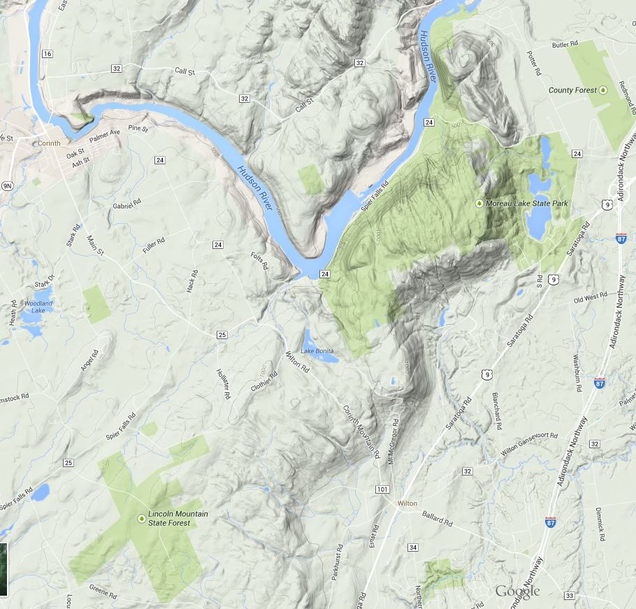 |
| Image from Google Maps showing the location and terrain of the Park. The park includes significant areas northwest of the Hudson not represented in this map as public land (the light green shade) . |
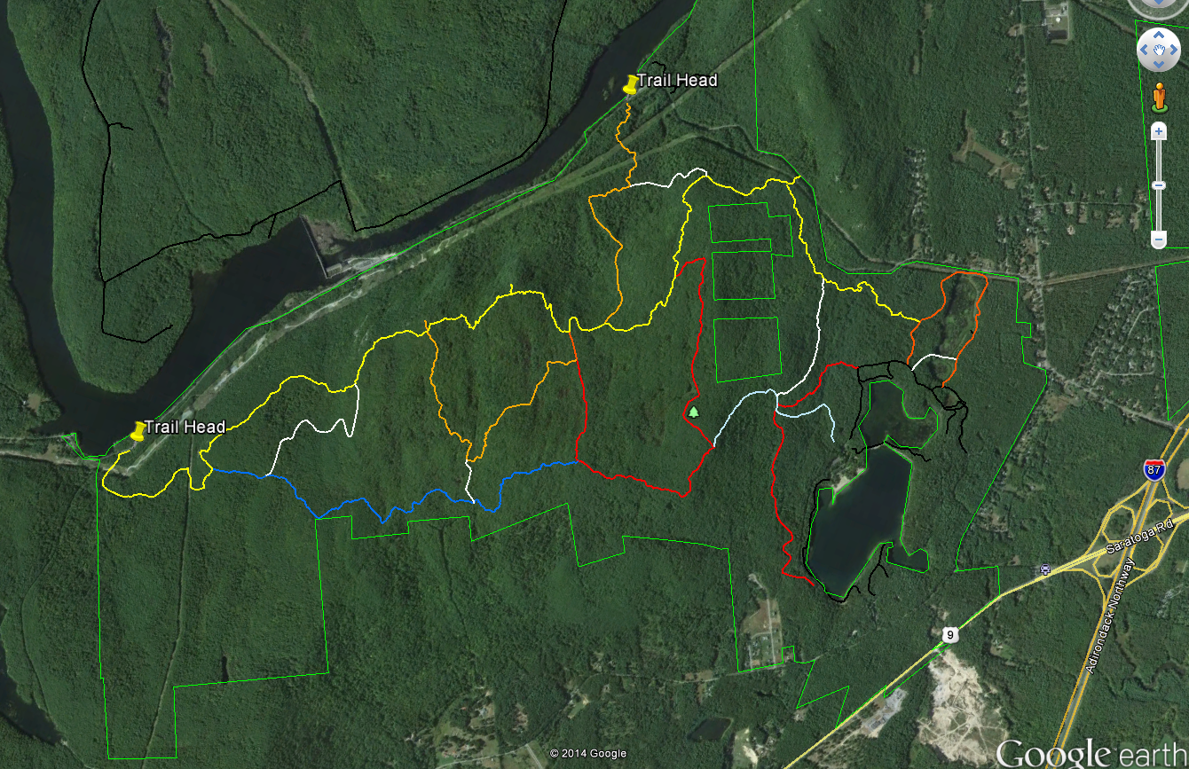 |
| Image from Google Earth showing the trails |
Some maps name this section of the ridge Grant Mountain but it would take some searching to find the summit. The ridge top area lies at an elevation of between 1000 and 1250 feet with numerous steep sided glacial cuts and small rocky ridges imparting an unexpected ruggedness to the terrain. Examination of a topographic map of the area shows that the Palmertown Range is part of the of the larger Adirondack uplift. Grant Mountain is defined by a glacial cirque and escarpment on the east side and by the gorge cut by the Hudson River on the west. You can see this clearly using the “terrain” (topographic) view in Google Maps (
https://goo.gl/maps/AOaPa).
The map above (from Google Earth) shows the Moreau Lake State Park trail system with two of the west side trail-heads marked. As a point of reference, Northway (I-87) exit 17 is seen on the right side of the map. Spier Falls Road runs along the Hudson River between the two marked trail heads and a 3rd trail-head is found where the yellow trail intersects the green park boundary line in the upper right part of the image. Spier Falls Dam creates the prominent widening of Hudson in the center left of the image. The colored lines show most (but not all) of the trails in MLSP and you can download the trails file from the park website. The file is in the KML format that can be opened using Google Earth. To get some idea of the scale, from the trail-head marker on the left to the point where yellow joins orange on the right is about 4.5 miles.
There are several places along the yellow trail with good views of the Hudson River and the southeastern Adirondacks and an excellent view of Moreau Lake (and east toward Vermont) can be had at the point where the red trail joins the light blue trail. But the views are just icing for me; the ridge top area holds an intriguing and attractive landscape. The terrain is varied and it is overlaid with a matrix of past human activities and the effects of those activities. Much of the forest appears to be 100 year old (approximately) second growth but the effects of more recent logging or fire are seen in some areas. A few abandoned carriage roads can be found but I've seen no sign of pastures or structures.
The most common ecological communities of the ridge top area are the Appalachian Oak-Pine, Beech-Maple and Hemlock Northern Hardwood Forest types. At smaller scales perhaps a half-dozen additional community types present (see the notes at the end). Interesting, from an ecological perspective is that the central section is poorly drained with numerous small marshes and seasonal wet spots. These wet areas are interspersed with dry, rocky, ridges -with thin soil- where Chestnut Oaks are the dominant tree species. This combination is found around the edges of the Adirondacks uplands but it is uncommon in the interior of the range.
Over the coming weeks I'll add posts describing the natural and environmental history of this fascinating area but for now some photos will have to suffice.
 |
| Fungus seen along the trail. If anyone can ID this please leave a comment. |
 |
| The Hudson just north of the Spier Falls Dam. The boat launch is located at roughly the lower left corner of the picture. |
 |
| A small marsh. |
 |
| Moreau Lake and the view looking east. |
 |
| Looking northwest from a view point on the yellow trail. |
 |
| Looking west across the southern Adirondacks; also from the yellow trail. |
 |
| Spier Falls Dam on the Hudson seen from a view point on the yellow trail. |