There is no inherent connection between the two hikes discussed in this post. Other than both are close to Long Lake and Elle and I walked the trails on successive days in late April 2016.
Goodman Mountain
Goodman Mountain is a small mountain near the southern end of Tupper Lake. Approaching on Route 30 from Long Lake the trailhead is on the right a half mile before you reach the intersection with Route 421. Both the mountain and the trail are named to honor Andrew Goodman. In 1964 Goodman and fellow civil rights workers James Chaney and Michael Schwerner where murdered by members of the Klu Klux Klan while working in Mississippi to register African Americans to vote. Goodman's family had a camp nearby and he was known to have climbed to the top of this mountain to enjoy the great views. The USGS renamed the mountain in 2002 and the new trail was dedicated in 2014.
The route covers just 1.6 miles and about half that distance is on what used to be a paved road (the first half mile is handicapped accessible). From the point where the trail leaves the old road to the top it is generally easy walking with just a couple moderately steep stretches. The trail passes through a very attractive and rapidly maturing second growth forest and the views from the summit are outstanding. This is as nice a short hike as you'll find anywhere in the Adirondacks and it's a great family-friendly route.
Views to the south, southeast and southwest are unobstructed and by seeking out openings in the trees you can see east towards the high peaks and into the wild country west of Tupper Lake. Prominent in the foreground is the sharply contoured summit of Coney Mountain just a couple of miles away. We owe our visit to Goodman Mountain to the extreme popularity of the Coney Mountain trail. We had intended to make the short walk (.75 miles) to the top of Coney. But arriving at the trailhead we found the parking lot full with a half dozen additional cars parked along the road. Coney is a small mountain and that seemed like a bit much. Continuing on and considering our options the sign for the Goodman Mtn. trail soon appeared. Coney has unmatched views but the trail is overused and not particularly attractive. We'll take Goodman any day.
Looking south from Goodman Mountain. Coney Mountain in the foreground and Blue mountain in the distance.
Sargent Ponds
We planned to hike the Sargent three,
lower, middle, upper.
But one we'll see another day
or we will miss our supper.
Two trails reach the Sargent Ponds from the north (access from Northpoint Road; intersection with Rte 30 in Deerland south of Long Lake Village). The two trails are connected and the trailheads are separated by just a mile and half of lightly-used rural roadway. Combining the trails with a walk along the road makes for a very pleasant loop hike of just over seven miles.
The second trail (further west) covers 2.2 miles to Lower Sargent Pond. A 1.7 mile connecting trail then takes you to a short spur trail that leads to the shore of upper Sargent Pond. From the intersection the trail returns to the road at the more eastern of the two trailheads.
Sargent Pond Loop. Map image from Google Earth.
Much of the route passes through hardwood forests with the canopy provided almost exclusively by large Yellow Birch (many reaching 30 inches diameter). This species is common in hardwood stands throughout the Adirondacks but the absence of the Birch's close friend the Maple leads me to think that this area was selectively logged. In any case, it's a generally attractive route.
Lower Sargent Pond
Fungus never sleeps. That's something you should keep in mind.
Upper Sargent Pond
Elle and one of the large Yellow Birch that dominate the forests seen along much of the route. This tree has a diameter just over 30 inches at four feet.
I'm dedicating this post to my Dad. He turned 82 yesterday. Thanks Dad for instilling my love of the Adirondacks and of hiking. Even though you'll have trouble believing this, given all the trouble you had "getting me off my duff" when I was a kid. I just want you to know that I was saving my energy for these crazy hikes. Thanks for everything. I owe it all to you.
Three separate marked trails reach the Pine Orchard east of Wells. The route from the north starts on Route 8 and leads initially to the site of a long abandoned maple sugaring operation. This is known as the Girards Sugarbush trail (Note: There are two possible starting points for this route; I'm describing the shorter one. See the notes at the end for details on the shortcut).
Route to the Pine Orchard starting at the Girards' Sugarbush trailhead on Rte 8, northeast of Wells.
This northern route to the Pine Orchard follows an abandoned woods road through the heart of the Wilcox Lake Wild Forest. The route has its' own unique appeal but it's a tough walk. The entire 5.5 mile route is marked as a snowmobile trail and for much of the way it is wet and rough. Not surprising really; in the Adirondacks snowmobile trails tend to be wetter, rockier and more in-grown than well-used hiking trails. On the plus side snowmobile trails generally have good bridges and the two major brooks you encounter along this route are crossed by solid bridges. Adding to the fun is that whomever originally picked this route somehow managed to cover the entire distance without crossing any level ground. My GPS recorded the total elevation gain for the round trip as over 3000 feet. And trust me; that's an underestimate. This is a tough route.
In mid-march I wrote that Spring had arrived in the southern Adirondacks. In mid April, following a stretch of unusually cold weather it's fair to say that Winter has made a last stand. On April 12th, ponds and swamps were frozen over and a dusting of snow remained in shaded areas. Spring is coming, but not quite yet.
So why walk this trail? For starters, the Pine Orchard never fails to impress. If not for the existence of the easy route to the orchard from Flatters road this trail would see a lot more traffic. But that route does exist; so why walk this trail? The main appeal is that this is wild county with forests that are rapidly approaching what we imprecisely refer to as 'old growth'. Some of the best stands of old growth forest in the Adirondacks are located in the the southern third of the Park and the forests you pass through along this route are representative of that.
Barbara McMartin offers an explanation for why these forests exist in her The Great Forest Of the Adirondacks. And it starts with the timing. The first settlers and loggers who headed north in the decades following the revolutionary war were naturally drawn to the more accessible areas in what is now the southern portion of the Adirondack Park. Some land was logged or cleared for farming during that first wave of settlement but the rough terrain limited the extent. On top of that, areas logged before 1850 have now had over 150 years for the second growth to reach full size and for the forests to assume characteristics that we associate with old growth. There is no definitive point at which a forest becomes "old growth" but, in the southern Adirondacks, areas mostly undisturbed for more than 150 years exhibit many old-growth characteristics. There are additional successional steps between 'old growth' and a climax forest, but forests left to their own devices for 150 to 200 years are getting there.
The second reason that old growth is found in the southeast is that the industrial loggers of the 19th century were primarily interested in softwoods; spruce and pine for pulp and lumber and hemlock for the tanning industry. Much of the southern portion of the great Adirondack forest was dominated by hardwoods: Maple, Beech, Ash and Yellow Birch with a half dozen other species mixed in.There were softwoods in the southern Adirondacks but those stands tended to be smaller and more scattered. McMartin states that while selective logging for softwoods did take place in the south the hardwoods were commonly skipped over. This helps to accounts for the mature hardwoods seen all along the route described here.
This route lies entirely in the Wilcox Lake Wild Forest. Wild Forest is a land use designation that permits some uses not allowed in Wilderness areas including limited motorized access. Still, coming upon the fireplace and outhouse pictured above was surprising and amusing. The fireplace is of the style commonly seen at DEC campgrounds, so maybe there was some easier access to this spot in the past. As it stands today these "facilities" sit idly in the middle of nowhere.
Forest scene just north of the Pine Orchard.
McMartin's hypothesis that some of the best old stands of Adirondack forest are in the south is borne out by what we see today. Mature hardwoods are seen all along this route and there is a stand just north of the Pine Orchard where the canopy trees are mostly Maples with diameters greater than 30 inches with some even larger trees mixed in. This is what an old growth hardwood forest looks like.
Notes:
There is a marked trailhead for Girards' Sugarbush on NY Route 8 two miles north of the intersection of Routes 8 and 30 (on trail signs this is referred to as 'Griffens'. From this spot the trail passes over rough terrains for over a mile to the point where it intersects the route I've described less than 100 yards from Rte. 8. To bypass this section, pass the formal trailhead (assuming you are approaching from Wells), and drive an additional 1.5 miles (approximately) and watch for an overgrown woods road on the right. It can be hard to spot but there is a sign announcing Sacandaga River Access Parking at the point where the trail enters the woods. If you reach that parking area (also on the right) you have gone to far. There is plenty of parking alongside the road right at the trailhead or you can pull into the parking area and walk back the .2 miles to the start of the trail. There is a trail register 100 yards in so you'll know for sure that you are the right spot.
Sometimes things come together in unexpected ways and you just have to savor the moment. It was four PM and I had hiked to County Line Lake from the trailhead on Pinnacle Road (southwest of Benson NY). I'd scrambled part way up the small unnamed mountain north of the lake and now I was just a mile from the trailhead at the crossing of the northeast branch of Pinnacle Creek. Pausing, I was struck by what a perfect day it was. March 26th on the calendar but not the day I had expected. Temperature in the upper 40s. A brilliant blue cloudless sky. Not an annoying insect of any kind to be seen. And the transition from winter to spring nearly complete.
Route to County Line Lake from Pinnacle Road. The side trip to the right was to the vly that is the primary source of the NE branch of Pinnacle Creek. Image from Google Maps
Ten hour earlier I had been drinking coffee and scanning a map of the southern Adirondacks looking for a place to get out for a hike. I always have a few options tucked away in the back of my mind but I was looking for someplace completely new. One of the things I love about the Adirondacks is that there are so many unique and interesting places to explore. And there it was; County Line Lake.
A small cascade on the slope of Pigeon Mountain.
As beautiful as the day was it's still March in the Adirondacks. The overnight temperature at 2500 feet had certainly dipped into the 20s. The light spray from a small cascade encased these leaves in ice.
Beaver shape the Adirondack landscape. Pinnacle creek flows through a valley where Beaver create small ponds in an endless cycle of use and reuse.
Most years on March 26th this area would still be firmly held in Winter's grasp with plenty of snow and ice. But the winter of 2015-2016 has not been most years. This winter is now in the books as one of the mildest since records have been kept here abouts. A few lonely patches of ice remain in sheltered places above 2000 feet, but very minimal. And, most remarkable of all, even the dreaded "mud season" has nearly past. In a typical winter the first couple feet of soil freezes solid. In the spring, after the snow melts, that frozen soil transitions first into a soupy mud; mud season. But not this year, for the most part this route has already dried out.
County Line Lake. March 26th, 2016. The lake sits at 2500 feet and, it was still iced over. But probably not for long. The ice was out on all the water lower down.
The namesake of this route, County Line Lake is pictured above. It's a decent sized body of water but I couldn't get a sense of the depth and it might be shallow. Bill Ingersoll notes in his Discover the Southern Adirondacks that the lake has been devoid of fish for many years. And that fits. The trail arrives at the southeast corner of the lake and basically just ends. The herd paths you typically find around a body of water that attracts fishermen and campers are not present. I crossed the inlet stream and fought through a quarter mile of brush along the north shore of the lake. From there I went up the slope of the unnamed mountain that borders the lake on the north. I wasn't looking to get to the top. I just wanted to avoid a return trip through the tangle closer to the shore. This strategy was only partly successful. The entire slope is brushy with almost no canopy sized trees.
At 2600 feet on the unnamed mountain north of County Line Lake. A snarled mess of stunted Beech saplings dominate this slope.
The forest on this slope is odd. I saw no signs of a blowdown event or fire or logging. But there are almost no large trees. The stunted trees visible in the photograph (above) are mostly American Beech and it may be that Beech Bark Disease has disrupted the normal cycle of forest succession. American Beech is a pioneer species and when the forest canopy is disturbed Beech quickly fill in. However, under some circumstances, Beech Bark Disease can kill the Beech trees before they get large enough to shade the soil so that moister loving species can get going. This can set up a cycle where Beeches fill in, die off, and fill in again. This creates a tangle of stunted Beeches that I have seen referred to as a "beech hell". Of course, that may not be what is going on at this location. The soil on this slope looked to be thin and the southwestern exposure had already left the slope bone dry. Interestingly, the few larger tree that are present (not tall but judging by the bark old) looked to be Black Cherry. Not sure what to make of that. I'd appreciate knowing the fire/logging history of this area to get a better sense of what might have led to the current state.
A beaver meadow on the inlet to County Line Lake. A short distance from the lake.
Along the inlet stream.
On my return trip I paid closer attention to the forest and it struck me that the lake is not the main attraction of this route (I might see that differently on a hot July day). The trail passes through stretches of attractive middle-aged forest with some large trees ( diameter > 30 inches) present. But it's the variety, the interesting terrain, and the streams that make this route the gem that it is.
Returning to where this tale began, sitting on the bank of Pinnacle Creek with the late afternoon light filtering through the trees, I was struck by the beauty of the spot. The first mile and a half of the route passes through a magnificent Hemlock forest; open, cool and inviting. Resting for a minute I didn't want the day to end. And hey, with three hours of daylight left why not follow the stream to it's source? Within 30 minutes I had reached the swampy vly that is the source of this brook. When the beaver have raised the water level this is probably a nice spot. But on this day the water level was low and the pond was surrounded by a mud flat. Not that it mattered. The 1/2 mile walk along the stream is as good as it gets. Through a deep hemlock forest along a brook with numerous cascades. After resting for a few minutes it was time to head for home.
Mallards on the shallow pond (vly) that is the source of the northeast tributary of Pinnacle Creek.
Hikers planning to walk the Northville Lake Placid Trail (NLTP) from south to north have long faced a bit of dilemma in deciding where to start. From the official trailhead in the village of Northville the first twelve miles of the route were along paved roads and you would have walked 14 miles, at a minimum, to reach a place where you could camp. For that reason, many thru hikers started their journey at the so called "Upper Benson" trailhead on Godfrey road.
Two new sections of trail change that calculation completely. A thru hiker might still chose to start at Godfrey road but, if you do, you'll miss two compelling new segments of the trail. The first section runs from Collins Gifford Valley Road near Northville to the Benson Road; covering a distance of 8.6 miles. The second section links the Benson Road crossing with the original route at the place where the original route crossed the West Stony Creek North Branch (the bridge about 2 miles from Godfrey Road parking area). This second section covers seven miles and both sections together add 15 miles of new trail to the the NLTP.
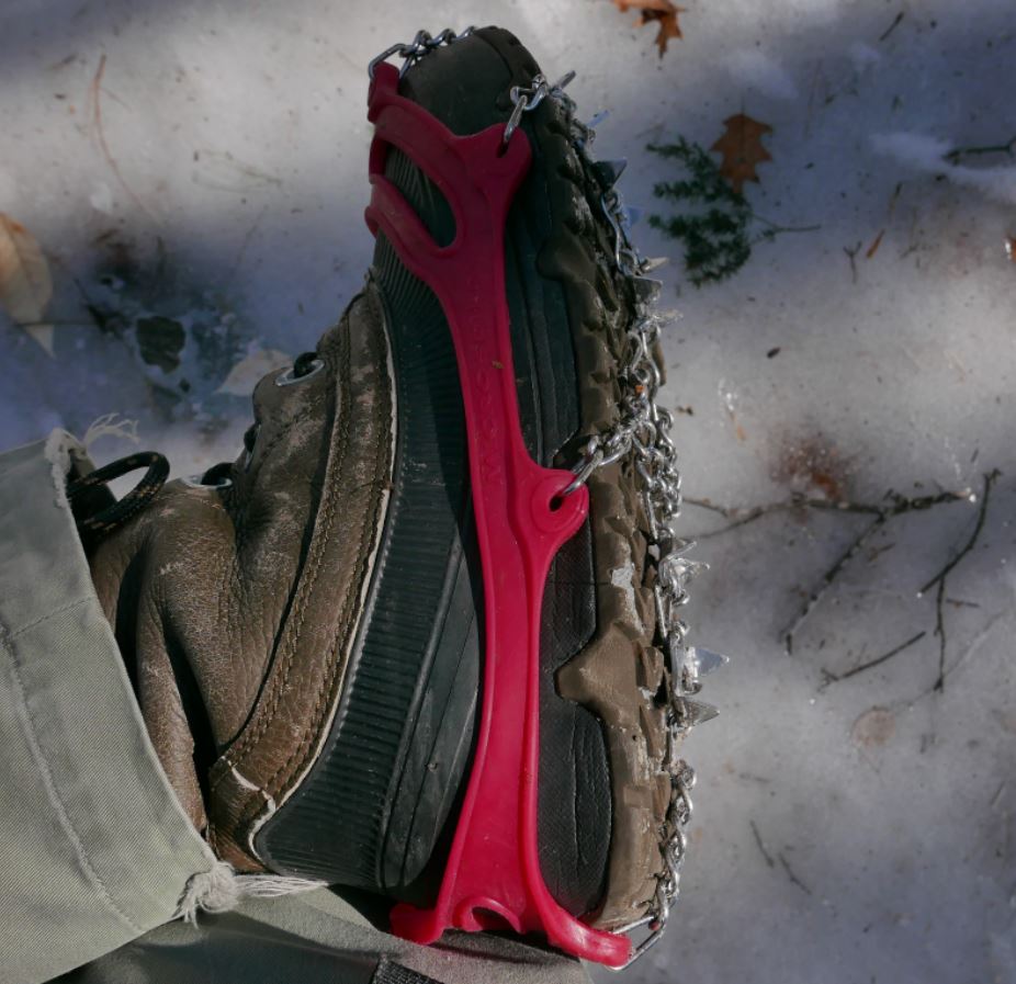
I recently walked significant portions of both of the new sections on successive weekends at the end of February and beginning of March 2016. Both trips, were made possible by the use of micro-spike "boot chains". In both cases the trails were extremely icy and neither excursion would have been possible without the micro-spikes (Images 1 and 2).
Image One
Image Two: Unusually icy conditions prevail in early spring 2016. Walking these trails would not have been practical without the use of micro-spikes.
The first of these two outings covered a portion of the the new trail that runs from the Benson Road to West Stony Creek North Branch (north of the Benson Road). The following weekend I walked the section starting at the brand new trailhead on Collins-Gifford Valley Road to the crossing of the West Stony Creek. Both hikes covered about ten miles for the round trip.
Notices at the trail registers warn that though a bridge is planned, currently there is no bridge over West Stony Creek. This is important for anyone planning to start a NLTP journey at the Gifford Valley trailhead because West Stony Creek is a significant stream. The creek can easily be forded at times of low water, but in the spring, or after heavy rains, it could present an impassable barrier.
Image Three: The only other hiker I saw on two full days of hiking is seen above on the far side of Stony Creek. He evidently hiked from the Benson road south to the creek crossing.
Not surprisingly, on the day I was there, March 6, 2016, fording the stream would have been a risky undertaking. West Stony Creek at the place where the trail crosses is wide and in early spring it carries a significant volume of water. The creek does look to be shallow, probably no more than knee deep, but with lots of ice and freezing water to contend with I can't imagine a casual hiker trying to cross at this time of year. The crossing will look completely different in six weeks and by mid-summer it might be possible cross without getting your feet wet. But without a bridge you need to factor the creek into any plan to pass thru this section. I shot a couple of short videos to illustrate.
I'm going to come back to these two outings in future posts, but for now I'll let a quick summary and some photos do the talking. Setting aside the value that these re-routes provide by finishing the long story of the NLTP, the first section, from the Collins Gifford Valley Road to the West Stony Creek crossing is a great new hiking route all on its' own. After climbing steadily for the first mile this section of trail enters a rapidly maturing oak forest that is notably different from forests along most of the NLTP. Then, at just under two miles you reach Mud Pond. The setting for the pond is attractive and open rock is visible on the ridge line northeast of the pond. The ridge appears to be easy to reach and probably has some nice views. I'm planning to return at some point to see for myself.
Image Four: Mud Pond in late winter splendor.
Past the pond the trail passes through a complex of small ridges coming down from the surrounding mountains and it crosses two stream carved valleys. Along the way the forest transitions to a more typical mix of Hemlock and northern hardwoods. This is a very attractive section of trail and the second major stream crossing, about a mile from Stony Creek, is at the head of a small gorge that also looks to be well worth a visit with time to explore.
Image Five: Details seen along the trail.
At just under five miles the trail reaches the ford of West Stony Creek. The area of the crossing, on the south side of the creek, looks to have a number of attractive potential camping spots and I suspect that this will become a well used destination.
All in all, the five mile stretch south of Stony Creek is a lovely hike on its' own terms and I have no doubt that I will return soon. When it is possible to cross it's 2.8 miles from the north bank of the creek to the Benson Road. Walking that section of trail is near the top of my list of possible future outings.
The second of my two recent hikes started at the Benson Road and covered the first five miles of the seven mile route to where the new trail joins the prior route of the NLTP. That outing was similar to the one I've just described with very ice trail conditions defining the day. The highlights of this section include the passage of Woods Lake; a long-time favorite local destination. Along the mile long shore of the lake the trail traverses some splendidly rugged terrain in crossing a ridge of Little Cat Head mountain. Little Cat Head reaches barely 2000 feet in elevation but it's an intriguing mountain with potential viewpoints. From the ridge to the point where I turned around the trail passes through mostly young second growth forests with sections of more mature Hemlocks along a couple of small ridges. I suspect that the section from where I turned back to the place where the new trail joins the old route is more interesting, but I had to leave that for another day. The Ten mile round trip --crunching along over icy ground the whole way-- is my limit for this time of year.
Image Six: Glare ice along the shore of Woods Lake. Heavy rains in the prior week followed by a temperature plunge to near zero created hard ice conditions.
This is a follow up to my previous post on GPS accuracy. Basically, I returned to the same location --the wading pool in the Roosevelt Baths Quad at Saratoga Spa State Park-- and recorded additional sets of GPS fixes using the Garmin GPSMap 64s and the Garmin eTrex. Image One is a screen capture from Google Earth showing the results. The green markers represent the fixes recorded using the 64s and the red markers were recorded using the eTrex. The red dots represent the actual locations.
Image One: Screen capture from Google Earth. The green markers represent locations recorded by the Garmin GPSMap 64s and the red markers are from the Garmin eTrex Venture HC. The red dots show the points where I stood to record the locations.
My intent, as described in detail in the previous post, is to understand the level of accuracy that can be obtained using inexpensive (less than $300) GPS devices and to determine the factors that affect that accuracy. From that perspective, the average accuracy of the fixes recorded on this visit to the Spa State Park site are similar to those obtained on the previous visit. Slightly better overall, but not substantially different.
The majority of the fixes recorded by both units where within ten feet of the actual and both recorded some fixes within five feet of the actual. Using the criteria discussed in the previous post these are excellent results. My methodology is to record a fix with each unit, walk to the next location and repeat the process. Starting at the upper left I proceeded to the lower left, lower right, and upper right corners of the pool. The green marker labeled 001 was the first fix recorded using the 64s and the red marker labeled 001 was obtained a few seconds later using the eTrex. I made three circuits so there are three markers for each unit at each corner.
On the third circuit I used the location averaging feature available on both devices. When using averaging the GPS device grabs a sequence of fixes at the location and averages those fixes to produce a single fix that should be more accurate. I have not seen a description of the algorithm these devices use to do the averaging, but an educated guess is that the units temporarily store fixes obtained using different sub-sets of the full set of satellites from which the unit is receiving signals. Comparing these trial fixes would allow the unit to drop signals that don't fit well with the others. See the previous post for a discussion of conditions that can reduce GPS accuracy.
To make it easier to see how these results compare I grabbed an additional screen capture showing a closer view of the lower left corner of the pool (the second stop on the circuit). And this brings me right back to the title of the first post; GPS accuracy is not a simple matter. As you can see, the distance from the Green marker 010 to the actual is 1.3 feet as measured using the Google Earth measurement tool. That fix, obtained on the 3rd circuit of the pool using the averaging feature of the 64s, was the most accurate fix obtained by either unit. But the 64s also recorded one of the worst fixes of the day at that same location. The green 002 marker, recorded by the 64s on the first circuit of the pool, is 16 feet away from the actual. That's not terrible but it is the 2nd worst result for either device on any of the three circuits. Given that the second time around the 64s recorded a fix about five feet away from the actual (green 006) it was probably the case that the 002 marker incorporated a signal from a satellite with corrections pending, and that that through off the result.
In summary, the accuracy you obtain using inexpensive GPS devices will almost always be better than the 30 foot level that the manufacturers claim for these devices. And it can be much much better with best case results under five feet. But that level of accuracy requires an understanding of how these devices work and what factors reduce accuracy. To obtain these 'best case' results you should turn your device on several minutes before recording the first fix -this allows your GPS device to download the satellite correction data it needs to make proper use of each satellite. Secondly, use the averaging feature of your GPS if it has one. Or, take several readings at the same location a few seconds apart and do the averaging yourself.
Most important, be skeptical. It may be that the one foot accuracy I got on this go round is a fluke. After all, I didn't see that on my first visit to the same site. Leaving me to wonder, what will the next visit show?
Image Two: Screen capture from Google Earth. The 1.3 feet distance from the actual location to the green marker 010 (third circuit) was most accurate fix by either unit. Confouding that, the green 002 marker, also recorded by the 64s, was one of the worst.
GPS accuracy is a tricky topic to discuss. There are a number of factors that limit GPS accuracy and the 'accuracy' of any GPS device varies almost continuously while in use. Even so, a few general rules do apply and I'm going to discuss what I've learned here.
You probably have GPS in your smartphone (and possibly your camera or other devices) but I'm going to focus on hand-held 'recreational' GPS units. This type of GPS receiver can be purchased for under $100 or you might spend as much as $400 (more than that and you are looking at a different class of device). I'm currently working with a Garmin GPSMap 64s that I bought for $230. Over the last 15 years I've purchased three similar devices:
The GPSMap 64s - purchased in Jan. 2016, referred to throughout as the '64s'
A Garmin eTrex Venture HC. Six or seven years old, the 'eTrex'. Around $130
A Magellan eXplorist 210. Fifteen years old. I no longer use this device.
GPS receivers like these are typically described as being accurate to 10 meters (30 feet). But that is the kind of safe generalization that manufactures make to avoid legal disputes. Under favorable conditions these units common fix locations within 10 to 15 of the actual location. Under ideal conditions these units can provide coordinates that are within a few feet of the exact location. If an even higher level of accuracy is needed you can purchase GPS receivers that come with very sensitive external antennas and that make use of ground-based correction signals and post processing of the raw GPS data. At the highest end these unit achieve sub-centimeter accuracy (better than half an inch). These units currently cost thousands of dollars.
But how do you judge the accuracy of locations saved using your GPS receiver? One way is to upload the 'marks' or 'waypoints' captured by your GPS device to a computer for display on top of a map or geographically referenced imagery. I do this using Google Earth. To judge accuracy at the level of a few feet you'll need to record locations at a place that you can identify precisely on a map. The place that I'm using for these tests is seen in Image One. This satellite view from Google Earth shows a complex of buildings located in the Saratoga Spa State Park near my home. The square in the center of the image is a wading pool (it was empty when this satellite image was made). Image Two shows the wading pool with the map zoomed in for a closer look. In Image Two I added a marker place precisely on one corner of the wading pool. The properties dialog then shows the geographic coordinates for that location.
Image One: Building complex in Saratoga Spa State Park. The square shape in the center of the image is a wading pool. For scale, the wading pool is 93 feet on a side. Image captured from Google Earth.
Image Two: The wading pool again, this time zoomed in for a closer view. A marker was added and the properties dialog shows the geographic coordinates of the marker (in the Decimal Degrees format). Coordinates captured using GPS can be compared with a known location such as the corner of the pool to judge accuracy. Image captured from Google Earth.
As mentioned, using GPS to record coordinates that are less than 5 feet from the actual location typically requires the use of some type of correction technology. Correction is needed because various factors, some of which vary locally, interact in ways that reduce GPS accuracy. GPS satellites reside in geo-synchronous orbits --the satellites orbit in a constant position relative to the surface of the earth-- and the accuracy of GPS hinges on knowing the precise orbital position of each satellite. But those orbits are constantly perturbed by outside forces and regular correction is needed to compensate for this. This type of correction is built into the system but it is not instantaneous. At any given point in time some satellites are not exactly where the system thinks they are and this reduces accuracy. Which is one reason why more is better when it comes to the number of satellites your GPS receiver can use. Signals from additional satellites can be used to average out some types of errors in the system.
To get really accurate locations your device needs to make use of signals from ground-based stations. These stations broadcast signals that your GPS receiver can incorporate into its' calculations and these stations don't move. The location of the ground based stations is known with great precision. Some consumer GPS receivers, including the Garmin GPSMap 64s, can use the WAAS ground correction network but I'm not clear on when this is used and the effect that it has on the accuracy of locations recorded using the 64s, The underlying problem with ground-based correction is that you need to be within the range and coverage area of a transmitter. Currently this is common in urban areas and uncommon away from cities. [Note: I've really over-simplified this, follow the link above for more detailed information]
Really good accuracy also requires the use of a highly sensitive antenna and this is probably the most significant factor in limiting best case accuracy in low cost GPS receivers. This is especially true when using GPS in the dense forests of the Adirondacks. Your GPS receiver must receive signals from at least four satellites (three provides a rudimentary fix) and these signals can be blocked by a dense tree canopy as well as by mountains or buildings. Intriguingly, the GPSMap 64s has a port that allows for the use of an external antenna. I have not yet begun to explore what that might mean in terms of the best accuracy level this receiver can achieve.
But, without further ado, let's look at some comparisons. I recently did an informal comparison of the accuracy of locations recorded using a Garmin GPSMap 64s compared results obtained using the older Garmin eTrex. I marked the same locations using the GPS in my smartphone to provide an additional set of comparisons. Image 3 shows the results.
Image Three:
I recorded the location of each of the four corners of the wading pool shown in the images above using each device. Since the corners have indents I marked the exact locations with the red circles to show where I took the measurements. Locations recorded using the 64s are represented by the green markers (note that the marker points are the at the recorded location). The locations recorded using the eTrex are represented by the purple markers. And the locations recorded using my phone are represented by the pink markers. As you can see, the 64s and eTrex achieved similar levels of accuracy. The eTrex was actually the winner; the mark closest to the physical location was recorded by the eTrex and that mark is about five feet away from the map image location. However, the 64s was more consistent and that also could be used to decide which device is "more accurate." This was a bad day for the phone. I usually get decent results using the GPS in my phone but on this day at that place it was all over the map. One mark, labeled Phone-3, seen on the left side in the image, was off by almost 200 feet. It should have been around the corner of the wading pool at lower right.
The extra mark at the upper right, labeled "E4b" was recorded by the eTrex and I included it to support my contention that the 64s was more consistent. I actually recorded two marks on each device; standing in the same spot. These marks were generally very close to each other but in this one case the first mark recorded by the eTrex was 25 feet away. Inconsistent.
A few conclusions can be drawn from this test. For starters, while the place and conditions at the time I recorded the data were favorable, the results are not particularly impressive. Both of the Garmin receivers marked the locations at points within ten feet of the actual, but only a couple were with five feet. I plan to return at a different time of day to repeat the test to see how much the results vary. Different levels of accuracy are to be expected because at different times your receiver will obtain GPS signals from different satellites. That the eTrex unit produced the closest marks could actually be an accident. I've been comparing the fixes obtained using both devices informally for over a month and in nearly every case the 64s has performed better. As the title of this post says, GPS accuracy is not a simple matter.
Image Four
Recording fixed locations under controlled conditions is interesting, but my main use for these devices is to record tracks while hiking in the Adirondacks. Image four shows a portion of a track recorded by both devices on a recent outing. The light blue line represents the track recorded by the 64s and the purple line is from the eTrex. The 64s track is more accurate and more precise. This comparison is interesting because it removes bias from the comparison (More on that in a future post).
My contention that the the tracks recorded by the 64s are more accurate comes from knowing the details of this outing. In the lower part of the image, the four distinct lines should overlap almost perfectly because that portion of the route follows a path that I walked along on the inbound portion of the hike and then again, in the opposite direction, on my return. My actual route might have varied by a few feet in places but those lines should basically overlap. In places there could be differences of a few feet between the inbound and outbound tracks but the two tracks should nearly overlap.
Measuring the gap in Google Earth I find that the it averages about 15 feet for the track recorded by the 64s and by 40 feet for the track recorded by the eTrex. In this context the 64s was significantly more accurate.
In this post I'm going to touch on three regular topics for this blog:
Hiking in Moreau Lake State Park (MLSP)
Old Trees
GPS Technologies
Looking across the Hudson towards the Palmertown ridge (and the main body of Moreau Lake State Park). Spier Falls Road is visible in the foreground on the far shore.
I got out yesterday (Jan. 18, 2016) for a hike on the east side of the Hudson River in Moreau Lake State Park (MLSP). Starting at an informal parking area on Call Street (between Queensbury and Corinth) this was a bushwhacking trip of just under six miles (round trip). Even so, it was a rather tough day. It was cold (mid-teens at best), the ground was covered with a layer of solid ice with an inch of snow on top and, and the route crossed a series of deep ravines cut by the streams that flow down from the surrounding hills into the Hudson. Only the last mile; from the point opposite the Sherman Island boat launch on Spier Falls Road to the Spier Falls dam itself was easy walking. Worth mentioning is that I could not have made this trip without the "micro-spikes" that I now carry on all Winter outings. These "boot chains" have exceeded my expectations at every use (available from many sources, here is one).
The area in question is across the Hudson River from the main body of MLSP and it is little known and little used. Probably the best access is from Hawk Road (previous post here), but parking at Hawk Road is a problem in the Winter and it's a lengthy walk from there to the section east of Spier Falls dam. This area is not wilderness by any stretch, but it is wild and in places the terrain is very rough. There are numerous old logging roads and places once cleared for agriculture throughout this section and the foundations of abandoned structures are seen in several places.
Foundation of an abandoned structure. The area around this foundation is relatively level and large enough for a field or pasture. The stand of same size trees indicates that this was cleared land in the past. Judging from the size of the trees, that was not the distant past. The agricultural use of this land was likely abandoned only in the past 30 to 40 years.
An ancient Maple
On the fringe of a once cleared agricultural area I came across a tree that has got to be one of the oldest in Moreau Lake State Park. It's a Sugar Maple (I think, mid-winter ID), and this tree is clearly in its twilight years. I didn't have my tape measure with me, but it is easily four feet in diameter.
This tree was located at the edge of an area that was probably cleared for grazing. And that's a common scenario for witness trees in the northeast. When the land was initially cleared trees growing along the edges of fields and pastures, and along stone walls, were left in place and became part of the agricultural landscape.
GPS - Garmin GPSMap 64S
One of my purposes for this outing was to put my new GPS receiver to the test. I've just purchased a Garmin GPSMap 64S. I've been thinking about acquiring a new GPS receiver for a while, but nothing I was seeing justified the cost. Then the clever robots at Amazon dropped an ad for the 64S on a web page I was viewing. At $230 the deal was too good to pass up.
Initial testing at Spa State Park over the weekend looked very promising, but I really wanted to put the unit through its' paces on a longer hike through a forested area. Not surprisingly, the 64S produces superior results on every front. For one thing, it's easier to use; no small consideration when it's 15 degrees with a stiff breeze blowing in your face. And while it is slightly larger and heavier than the eTrex it has a much better antenna. This is important when operating in thick forests and steep terrain.
It's not trivial to compare the accuracy of GPS units, at least not in the under $1000 dollar category where you have limited control over which satellites the receiver makes use of, but 64S has several features that should provide better and more consistent accuracy. The GPSMap 64 series receivers can make use of both the US GPS system as well as the Russian GLONASS satellites. All other things being equal more satellites should produce better results. The 64S is also capable of using the WAAS/EGNOS ground correction system. That's a big topic in its' own right and I'll discuss that further in a future post.
There are also a number of feature improvements, the most significant of which is that the 64S allows you to control the frequency at which it stores new locations when recording a track. This particularly useful when recording hiking routes. I set the 64S to add a new point to the track at one meter intervals; meaning that as you move along it stores one point per meter of travel (it can also be set to use a time differential). Set in this way you get a lot of data but it produces a much more detailed route than I could previously capture. This also avoids the annoying problem that I encountered with my older Garmin unit. When I would stop for a break, or for lunch, the older unit would continue to add points to the route based on a time differential (every 15 seconds would be my guess). So you would end up with a large number of points clustered around the location where you stopped. These could be cleaned from the data, but it was one more step in the process of producing a clean representation of the route.
I'm working on a detailed comparison of the performance of the 64S with my older receivers but the summary is that I don't know how I was getting by before.
Moreau Lake State Park, east of the Hudson River. The light blue line is my route. The heavy red line is the boundary of the section of the park that lies east of the Hudson River. Call Street is represented by the yellow line. The main section of the Park is on the west side of the Hudson, and Moreau Lake is just out of the area of the image at the lower right corner.
Marker A: Parking on Call Street
Marker B: Stream Valley
Marker C: Spier Falls Dam
Marker D: Sherman Island boat launch site on the west side of the Hudson (for reference)
Marker E: The Hawk Road Area
You might notice from the map that I wandered outside of the Park boundary at one point. That was inadvertent. At that point along this route you have to get over a steep-sided gully. Steep enough that given the icy conditions it was a challenge to find a place to get across. Most of the year it would be easier to stay in the park and get through this section.
A Section of the route showing each point captured by the GPS. Click the image to see it at full size. The GPSMap 64S, set to add a point to the track at one meter intervals captures a highly detailed representation of the route. Map Images from Google Earth.
As a loyal reader of this blog you know that when I go hiking I sometimes go off trail and do a bit of bushwhacking. I like to drudge up old and forgotten Adirondack routes and trails, and this fits nicely with searching around for patches of old growth forest or finding Beech trees that have BBD resistance. I commonly plan my routes so that my path at some point intersects a formal trail that I can follow out of the woods. Occasionally, when the trail I am seeking does not appear as expected, an alarming thought crosses my mind; "What if I cross the trail without realizing it?" This is usually accompanied by the even more disturbing thought; "What if I already crossed the trail and I'm heading off into the un-tracked wilderness? Oh no..." (then I recall that it is the Adirondacks, it might be wild but it is hardly un-tracked)
This has happened a few times but the the outcome has always been the same. Within a few minutes I step onto the the trail I was looking for. And this inevitably brings a smile because when you are bushwhacking even a lightly-used marked trail looks like a four-lane highway through the woods. From this I've developed a rule of thumb (Rule Number One of Bushwhacking); "You won't miss the trail, you'll spot it when you come to it, keep going." This rule has served me well because doubt can be a serious problem in its' own right. And doubt --edging towards panic-- has been the undoing of many a "lost" hiker or hunter.
This year I learned an interesting variation on my rule, which is; "you won't spot the trail if you are walking in the wrong direction." As you might imagine this corollary rule didn't appear out of the blue. I was attempting to reach Twin Ponds from the Thirteen Lake-Puffer Pond trail but tough conditions, and a late start, had caused me turn back short of the ponds. Heading back to rejoin the trail, which was less than a mile away, I decided to take an alternate route to avoid swampy terrain I had crossed on my way towards the ponds. After beating my way through rough terrain for nearly an hour I started to question my "rule number one of bushwhacking". The terrain didn't seem right and I really should have rejoined the trail by then.
I generally avoid using GPS for route finding but I had been recording my track using the GPS in my phone. So I pulled it out to have a look, and what I saw surprised me. If the GPS track was correct, I was going the wrong way. Only then did I pull the compass out of my pack and check my direction. Damn, I was traveling west when I wanted be going north. Correcting for this I came upon the trail after only a few minutes. I had been traveling parallel to it for some time. And the first rule of bushwhacking was confirmed. No way I would have crossed that trail without knowing it. (smile)
There was a lesson learned from this. It wasn't just over confidence, heck I hadn't even considered the possibility that I might be walking in the wrong direction. It was really a combination of hubris and laziness; the source of so many disasters, big and small. It was heavy overcast that day so there was no sun in the sky to help stay me on course and I hadn't bothered to check my compass. So now I have a new rule --Rule Number Two of Bushwhacking-- check your compass even if you already know the direction you are traveling.
I almost always have a couple of GPS devices with me, so why not just use GPS for route finding and eliminate the guess work? For starters, all the experts say that you shouldn't do it. Guidebooks, DEC and ADK websites, articles in the newspapers about hiker rescues, etc, all warn against "relying on electronic devices" to find your way when hiking. But this advice runs counter to common experience. Most of the time any decent GPS device, either a dedicated unit or the GPS feature built into a smartphone, can provide your location within a few yards. So why not use them?
The problem is that there are a variety of ways for these devices to fail or to give you incorrect information. Usually at a most inopportune moment. Still, the warning should really be that you should not trust to GPS alone to avoid getting lost. If know how to use your GPS device, and how it can fail you, then your GPS device is another tool you can use for route finding. I was going to conclude this little tale by saying "here are all the ways that GPS can fail you in the field; I've learned them all first hand." But that would have been foolish, I'm sure there other failure modes that I have not yet discovered. So here are some of the ways in which GPS can fail you in the field.
Your phone probably has a useful GPS capability but you must enable the "Location" feature for it to work. Setting your phone to record your track is pretty easy these days but if location is off it won't work. A good App should warn you if Location is off but this warning is easily overlooked. A good practice is to check your track on the phone periodically to make sure that all is well. Otherwise you might find that (the electronic equivalent) of birds have been following you through the forest and eating the breadcrumbs you have dropped.
Many people turn "Location" off because GPS puts a heavy load on your phone battery. My phone is over two years old and with "Location" turned on the battery lasts only six to eight hours; not enough for a full day of hiking. I carry a small auxiliary battery that I can use to recharge my phone in the field, but even this can go wrong. I recently returned from a trip to find that the track I thought I was recording ended 2/3rds of the way through the hike. At one point I had noted that phone battery was getting low and had plugged in the external battery. I had forgotten, however, that if the battery level in the phone falls below a certain level (10% I think) the phone disables the location feature to save itself (sort of HAL like). This had happened. The catch is that plugging in the external battery does not re-enable the GPS capabilities of the phone. So the later part of the track was not recorded.
The battery life of hand-held GPS units varies considerably and cold temperatures reduce the power output of all batteries. Lithium cells are much more effective in cold weather and should be used in GPS receivers. And, if you are using your GPS for anything more than amusement, you should carry spares (thanks Mom).
Anticipate that you will not have Cell service while hiking. The GPS in your phone will work because the GPS system does not rely on the cellular network. But this means that your phone will not be able to download maps while you are in the field. To see your location on a background map you must plan ahead and download the appropriate map imagery before you go. Otherwise you might find your phone showing your location as a dot on a blank background. It is surprisingly difficult to get the right maps onto many devices ahead of time so verify that you have the maps you need before you leave.
Beyond dead batteries and software failures any electronic device you take with you on a hike can fail. A common cause complete failures is having the device in your pocket when you wade into a lake or river and it's deeper than you thought. Oops.
Depending on where you are hiking you may find that your device cannot lock onto the GPS satellite network to give you an accurate location. Dedicated GPS units that can use both the US GPS network and the Russian GLONASS system are the best defense against this problem. The more satellites your receiver can use the better your chances of getting a signal.
Finally, there are a surprising number of ways for the compass feature of your GPS unit to be completely wrong. With practice and care you can get the correct heading from a GPS compass but I have learned to be skeptical of GPS-based compass readings.
The best hedge against all of these potential problems is to carry a standard compass, and the appropriate maps, and know how to put them to use.
Christmas in Long Lake is usually white or at least frozen. Even if there is no snow you expect ice, or an icy crust, especially in the forest. And, if all else fails, the mountain summits should be coated in white. But not this year. It's December 26th (2015) and there is no snow or ice to be seen -anywhere. Not in the shadows deep in the forest and not on distant summits. It looks like October before the first hard freeze.
The afternoon temperature passed 60 on Christmas eve and night time temperatures have dipped below 30 only a few times. There was a coating of snow on the summits in mid-November, (see my post on climbing Kempshall Mountain in early Nov.) but even that has completely disappeared.
It was under these unusual conditions that Elle and I set off on a walk to the historic Santanoni Preserve great camp complex. The ten mile round trip feeling like a walk on cool fall day.
Newcomb Lake with just a hint of ice. December 26th, 2015.
It's tempting to point a finger at climate change as the cause of this unusual weather but climate and weather operate on different scales; different time scales and different geographic scales. A point seemingly lost on those who consider the area occupied by the United States to be the entire world.
For example, when U.S. Senator Jimmy Inhofe brought a snowball into the Senate chamber (February, 2015) to make the point that it was cold outside so therefore climate change must be a hoax, he personally damaged our national standing around the globe (except apparently in Oklahoma). People around the world could only laugh and shake their heads at how silly the Americans have become. But they also had to wonder; is someone paying him to be stupid? Or, is he really unable to understand the distinction between weather and climate?
So now, looking at the reverse side of the coin, let's be clear, a single warm month in one small region does not mean much. If the current Octoberish weather becomes the norm for December then climate change might be the cause. And, as the argument that I commonly hear goes, so what if it does? The climate has always changed. We just have to adapt.
Ok, but it's still a question of scale. Based on our current knowledge of climate changes in the past, it's the pace of change that is the problem. An five degree increase in the average global temperature over a period of a thousand years would represent an extremely rapid rate of change. But even so, we would expect that thousand years to provide time for natural systems to adapt. It would be a disruptive event but ecosystems could adapt rather than collapse. That same change over a time span measured in decades it might very well be an event unprecedented in the history of the earth. We can only guess at what that scenario might bring but it is unlikely to be a good thing for a human population of eight to ten billion people. And it seems pretty foolish to give it a try to see what happens.
Still, gene preservation aside, we humans are selfish creatures and if the world is going to have a melt down those of us who live in the north can take advantage of it for a while. So let's get back to the hiking.
Elle, on the bridge that crosses Sucker Brook on the northeast corner of Newcomb Lake. This spot is a half mile past the camp complex. The trail passes through a beautiful forest with notable old cedars present.
By Adirondack standards, for December, this is a sunny day.
The bathhouse and beach. This spot is quarter mile from the main lodge site. It doesn't look like much at this time of year but there is a nice sand beach and this is a great spot for a swim on a hot day.
Ripples are visible in the sandy bottom of the lake. That's Moose Mountain near Moose Pond visible in the distance.
A lovely spot along the trail around Newcomb Lake. The trail around the lake is rugged and strikingly beautiful.