Wednesday, July 8, 2015

Round Lake: Enter the Boreal Core

The Adirondack Atlas refers to it as the 'boreal core'. No hard boundaries define this region and you'd be hard pressed to name the characteristics that make it distinct. The presence of boreal species and assemblages is certainly part of it, but it's also weather patterns and the glacial landscape dotted with lakes, streams and swamps. Lots and lots of swamps. For me it's the just feel of the place. Traveling west out of Long Lake you enter a landscape that feels different from areas to the east and south. The eastern Adirondacks can lay claim to the scenery but the core has the wildness.

Recent additions to the Forest Preserve make it easier than ever to enjoy that wildness. From the Adirondack Hotel in Long Lake it's barely 20 minutes to the first canoe put-in for the William C. Whitney/Round Lake Wilderness. There is a ranger station and canoe put-in for Little Tupper Lake at the old Whitney Industries Headquarters (with lots of parking) but you can also put your canoe in the water right along the road where you first come to Little Tupper Lake (there is good parking). From there you can head downstream following the flow into Round Lake or cross under the bridge into Little Tupper. From our base in Long Lake Elle and I were able to take advantage of this easy access on successive days over the long 4th of July weekend.

Round Lake is a large lake; 750 acres, but it is overshadowed by its' even larger neighbors; Little Tupper and Lake Lila. Perhaps this is why we saw only a smattering of people over the course of our two visits. Or maybe it was the black flies and mosquitoes. There's no shortage of either of those species.

The great boreal forests of Canada reach a southern limit in the Adirondacks. Vast amounts of water and long cold winters are necessary to produce the conditions in which boreal species thrive.
One of the small islands on Round Lake. Like the others, this island is wind swept and fragile.

Pitcher Plants in one of the many bogs and swamps that ring the lake.

The lake is home to multiple pairs of loons. We also spotted a Bald Eagle soaring overhead, a Cooper's Hawk (most likely ID) Cedar Waxwings and other common Adirondack species.  

What we used to call a Kodachrome moment.

I think this is Pickerelweed (Pontederia cordata).

Whatcha lookin at?
Dragon Flies are apparently attracted to pink. We know for sure that Black Flies are. Ellie's sweater seemed to collect them like a magnet.

You can just make out the dam on the outlet of Round Lake outlet. Click the picture to see the full size image. The dam comes in from the right (I'll try to get a better picture next time). The concrete dam is apparently just remnant of the original structure. My Dad worked on Whitney Park in the late 50s and early 60s and he tells me that at that time there were mechanisms to control the water level and a second wooden dam designed by Bert Stanton (my great uncle). The wooden dam is gone, and the concrete is eroding, but the remaining structure still raises the water level of Round Lake and of Little Tupper Lake. Looks like it raises the water level by only a couple of feet but, given the size of these two lakes, that's still a lot of water.

The Round Lake dam in an image captured from Google Earth. This view from downstream shows the remnant dam clearly coming into the flow from the left and you can see that the dam has been breached (intentionally???). The block of concrete seen in this image is the same one that you just make out in my photo (above). This image is from May of 2013 (according to the Google Earth metadata) at a time when the water level was well below the top of the concrete. My photo from July 6, 2015 was taken following a month of heavy rains and the water level in Round Lake was just an inch or so below the top of the concrete dam; a couple of feet higher than when this satellite image was made. That fits with what we had seen elsewhere on the lake. We already knew that Round Lake was just an inch or two below the high water marks visible on exposed rocks.  

Another image of the dam from Google Earth. 


Saturday, July 4, 2015

Burnt Mountain; Bushwhacking to an Interesting Summit Near Long Lake

As with Fishing Brook Mountain, Burnt Mountain is visible from Route 28n just east of Long Lake. It's a small peak --just 2600 feet-- and it would go mostly unnoticed except for the areas of open rock that are clearly visible near the summit. I have long wondered about the view from those rocks. Given that the summit is less than a mile (as the crow flies) from the Long Lake Reservoir I figured it could be done in a few hours; maybe a half day.

Taking advantage of the 4th of July holiday I set off to see. Turns out there are very good views. From the summit the view to the north is mostly open and with some exploring good views can be found for nearly every direction. I was a bit over optimistic on the difficulty however; the trip was not quite the half day outing I had expected. The seven mile round trip took 6 hours of nearly continuous walking and by the end I was very happy to see the car. Pretty much every bushwhacking trip I take turns out to be harder than expected. Maybe there's a lesson to be learned from that. Nah, the next one is bound to be easy.

From the summit of Burnt Mountain. Looking Northeast towards the High Peaks.
From the summit of Burnt Mountain, looking Northwest; Click on the photo to see the full size image and you can just make out a sliver of Long Lake in the upper left. Kempshall Mountain is the prominent rounded mountain in the right center with Blueberry Mountain just to its' left. Blueberry Mountain is another one of those trail-less and infrequently climbed peaks with great views. In the full image you can make out some of the south facing open areas on Blueberry mountain. And there are extensive open rock areas on the west side with great views of Long Lake.

From an opening on the south side of Burnt Mountain looking Southwest towards the west end of the Fishing Brook Range. 

Overview of the route. The first mile and a half is along the Northville Lake Placid Trail (NLPT) from Rte 28n. On the way up I passed the Long Lake Reservoir and walked due east until the slope steepened and turned south to angle towards the notch. For the return I followed the small brook that flows out of the notch on the south side of Burnt Mtn. down to Sandy Creek. Crossing the creek I continued west until I ran into the NLPT. As the day warmed the flying vermin started to find me in large numbers and I was highly motivated to find a trail where I could move along at a quicker pace. (image from Google Earth) 
Google Earth terrain view showing my circuitous route around the summit in more detail. The open rock on the left seemed like a good bet for by-passing the conifer thickets seen here in darker green, but the rock was a little steeper than liked for a solo bushwhacking trip so I beat my way through a lot of brush.

I hiked up to the notch on the south side of the mountain (on the left) and climbed up to the summit from there.  That route  was steep and passed through areas of dense thicket. Seeking an easier route I came down the east ridge (on the right). That way was much easier but left a climb of a couple hundred feet back up to the notch.  

It may be that the easiest route up Burnt Mountain is not up from the notch on the south but instead would work around the mountain on the north side and up the northeast slope to the top (upper right in the photo). The second growth forest on the north side of the mountain is Beech-Maple though nearly all of the large Beech trees have succumbed to Beech Bark Disease (BBD). Still, the forest is relatively open and easy to navigate with large Maples and Yellow Birch that I estimate to be in the 80-100 year age range. The only issue with climbing the mountain from the northeast is that the state land boundary crosses Burnt Mountain just east of the summit. So staying on public land might force you onto a less desirable route.


Spiders gotta weave

As always I was on the lookout for ecological anomalies. I didn't spot anything really notable but the notch on the south side of the mountain is pleasant and feels remote. The forests south of Rte. 28 are mostly mature second growth consisting primarily of Sugar Maples, Yellow Birch, Hemlock and on the higher slopes, Spruce. Many trees have reached full height with ABH diameters greater than 24 inches with a smattering of older trees with diameters approaching 36 inches. One notable tree was a Beech seen on the northwest slope of the mountain with a diameter of 36 inches. It was tipped up from the roots sometime in the past year or so but it looked to have been in good shape when it went over. The wood was still sound and there was very little indication of BBD. Had I seen it before it went over it would have been a notable specimen.

One final note; my father grew up in Long Lake and hunted in these woods as a young man in the 1950s. He tells me that there is an interesting cave somewhere in the notch on the south side of Burnt Mountain. No doubt the forests are much thicker there now because I saw no sign of it. Maybe next time.

Wednesday, May 27, 2015

Siamese Lakes Wilderness - Big Shanty River Driving Camp

Memorial Day; May, 25th, 2015. A thirteen mile round trip hike into the northern half of the 114,000 acre Siamese Ponds Wilderness. From Rte. 28 in North Hudson, turn (west) at the DEC sign for the Siamese Ponds Wilderness and Thirteenth Lake. Follow the signs to the "Old Farm Clearing" trail-head. There is a large parking area.

The "Old Farm Clearing" trailhead is a major access point for the Siamese Ponds Wilderness. My plan was to follow the main Sacandaga East Branch trail approximately seven miles to the suspension bridge that provides access to to the ponds for which the Wilderness area is named. There's a Lean-to near the bridge but nothing special about that location. It just seemed like a good turn around point and seven miles (each way) was fairly ambitious for this time of year.

I  didn't make it quite that far. Over the past few years my hiking mode has evolved into a slow (but steady) ramble through the forest. I peer into the woods looking for trees that are not like the others, plants that shouldn't be where they are, birds, other wildlife, unusual rock outcropping, signs of past human activity, elves and whatever else catches my eye. I take a lot of little side jaunts when I spot something interesting. So even though I left the car at 9:30 I had not reached the lean-to by my 1:30 turn around time. I figured I had maybe three-quarters of a mile left to go on the seven mile distance.

Not reaching the lean-to was of no concern but I was on the lookout for a sign for the "Big Shanty Lumber Driving Camp" mentioned in the 1994 edition of the ADK Guide to Trails of the Central Adirondacks. I didn't have the book with me but I thought it was located about a mile from the lean-to. If that was true, then I should have reached it. Of course, it might have fallen down or it might have been removed by a Hun or Vandal. And not knowing exactly where it was located, or even what it looked like, I might have simply missed it.

Oh well, time to turn back. Except, I could see a small clearing just 50 another yards down the trail. This one looked to be no different than a half-dozen others passed along the way. But why not, I decided to go just that bit further. And there it was, 20 feet off the trail. Just as the ADK book described it, large and rustic.

Big Shanty River Driving Camp, 1890.
I'd love to know the story behind this sign. Based on the rate of decay in the Adirondack forest it couldn't be more than 30 or 40 years old. But that's just a guess. If anyone knows more about this sign, and who put it up, please leave me a comment.

As for the rest of the hike, it was your standard late May outing in the Adirondacks. I participated in the annual Black Fly Count. And having encountered only a few thousand I can say with confidence that Black Fly numbers are way down this year. Or maybe the little buggers are just bidding their time. Waiting for warmer and wetter weather.

The Old Farm Clearing. There was some kind of tree farm surrounding this location and the clearing is well on its' way to filling in.

There are stands of  large hardwoods, including this Maple, along the trail. What I would call large second growth. Based on size and the bark I'd estimate this tree to be at least 150 years old. If so it would have been a small tree when this land was logged in the later part of the nineteenth century.

From the bridge over the East Branch of the Sacandaga River. Very low water following six weeks of dry weather.

East Branch of the Sacandaga (looking north) from near the Big Shanty sign.
Flood plain of the East Branch a couple of miles upstream from the Lean-to and suspension bridge. Very low water 
There are a few very large White Pine scattered through the forest along the river. This tree has to be 150 years old or older. How did it escape the loggers saw? Maybe they weren't interested in White Pine at that time.


Wednesday, May 20, 2015

Moreau Lake State Park Boundary (KML) for Google Earth

This is a follow up to my recent post on the addition of lands formerly held by the McGregor Correctional facility to Moreau Lake State Park. That post included a map image with a rough outline of the newly added parcel. I've refined that boundary and saved it to a KMZ format file that can be opened in Google Earth/Maps.

Link to the Moreau Lake State Park Boundary File
https://drive.google.com/file/d/0B3QHBL0PwDqWZFpxSG9nYU1BY0E/view?usp=sharing

Clicking the link will open a new browser window (or tab) showing Google Maps with the boundary layer displayed as an overlay. You can also download the boundary from Google Maps by clicking the Download Button (down arrow icon) on the Google Maps toolbar. The file is in the KML/KMZ format native to Google Earth/Maps. If you have Google Earth installed on your computer you can double click the downloaded file it to open it.

Image 1: Moreau Lake State Park Boundary.
Note: These boundaries are approximate and not official in any way. (Base map source: Google Earth)
The red outline represents the boundary of the main section of Moreau Lake State Park. The newly added "Lake Bonita" section is shown in blue (lower left). The area in brown (near the top) is the section along the Hudson River and north of Spier Falls Road, The section with the green outline is the area east of the Hudson (previous post on this here).

Image 2: The same boundary outlines viewed as an overlay in Google Maps. 
Viewing the boundary layer in Google Maps you might wonder why the outlines I've provided don't match the park boundary shown tinted light green. Most striking is that Maps only shows the main section of the Park. Probably because the data that Google used as the basis for the parks layer was created before the section east of the river was added. That question of "when was the data created" also applies to the new Lake Bonita section. The boundary outline I've provided was digitized from images provided with the press release announcing the land transfer (so again, it is only approximate).

Perhaps the most interesting discrepancy is the area outside of the red outline seen just below and left of Moreau Lake. That's not newly added so, is it in the park or outside of the park? It's probably a data error in Google Maps. No other source that I've seen includes that acreage in the Park and if you zoom in, as seen in Image 3, we see that there are streets located there. I know from having been there that there are houses on those streets so that area is probably not inside the State Park.

Image 3: The section in green, but outside of the red outline, is probably a data error. (Source Google Maps)
The outlines I've shared were digitized from base map layers obtained from several sources. My starting point was the official Park map and I edited and added detail using a base map layer from ArcGIS Online (Esri). My point in discussing these discrepancies is that geographic data usually represents a moment in time. If our subject of interest is represented by data that changes continuously then we can consider that data to be out-of-date the second we save it to a database. Even something far less dynamic --a State Park boundary for example-- will change over time and representations provided by varied sources will not necessarily be in agreement. And then there are errors of all kinds and the question of accuracy. But that's another whole story.

As a representation of the real world geographic data is uncertain. And uncertain is not the opposite of certain. It's a lot more complicated than that.


Monday, May 11, 2015

Lake Bonita - Moreau Lake State Park

It's not every day that a favorite local State Park has a good sized chunk of land added on. Especially when that addition includes an attractive lake that was previously off limits. But this is exactly what has happened at Moreau Lake State park. It was announced last week (May 2015) that 750 acres formerly controlled by the Mount McGregor Correctional Facility have been added to the park (official press release here).

A rough map of the area added to Moreau Lake State Park. The light blue outline shows the approximate boundary of the addition. Lake Bonita lies entirely inside the newly added parcel as does the Grant Cottage historic site. The red line represents the previous Park boundary and the colored lines inside that boundary show existing trails. Wilton Road passes through the addition and the prominent forest cut that intersects with Lake Bonita (from the top of the map) is an abandoned power line right of way. The even more prominent straight cut (gap in the forest) is a current power line ROW.  The buildings and infrastructure of the former correctional facility were not added to the park pending possible redevelopment. Note that the new parcel outline shown in this map was drawn by hand and is only approximate. The map is from Google Earth.

The minimum security Mount McGregor facility was closed in 2014 by New York State in a cost cutting move. Given that the 1100 acre Corrections property is mostly forested --and that it shared a 1.5 mile long boundary with Moreau Lake State Park-- the possibility that some portion might be added to the park received immediate local interest and support. Best of all, the corrections property included all of Lake Bonita. Lake Bonita is a 50 acre reservoir backed up by 150 foot long earth and rock fill dam across the headwaters of Beaver Brook (information on the dam). The lake is quite attractive and during a short visit on May 10th (2015) we saw a variety of water loving birds and what appeared to be Rock Bass spawning near the shore.

But the lake's most appealing characteristic is that it is undeveloped. A well maintained gravel road reaches the dam from Wilton Road and a second road reaches the east end of the lake from the former McGregor facility. The lake was the water supply for the prison and a pump house at that point is the only building visible on the entire lake shoreline.

The press release announcing the land transfer from Corrections to the State Park system noted that access is currently limited by a lack of parking and the absence of trails. We took that to mean that it's OK to visit if you can get there. Which is not to difficult if you are willing to hike and do a little bushwhacking. Probably the easiest way to visit right now is to hike the existing trail from Spier Falls Road to Lake Anne. Lake Anne sits right on the old property line between the Park and the Corrections department lands. From Lake Anne it is about 3/4 of a mile cross country to Lake Bonita. The only challenging part was getting around the extensive marsh found at the southeast end of Lake Anne. You could walk for a ways and then turn towards the lake, but it's been so dry that we went straight through it. We managed to keep our feet dry but we picked up a few hitchhikers while beating through the underbrush. Tick precautions are required if you go off trail anywhere in Moreau State Park.

Looking down the lake from near the east end. The dam is out of sight around the corner to the right.

Lake Bonita from near the dam. The lake is approximately half a mile long and 300 yards across at the widest point.


The dam on the northwest end of Lake Bonita.


History of Mount McGregor Part 1
History of Mount McGregor Part 2

Saturday, February 14, 2015

Geyser Creek to the Kaydeross

Most visitors to Saratoga Spa State Park experience Geyser Creek by strolling to see the impressive travertine deposits along its' banks or as the lovely stream that flows through the Geyser Creek picnic area. Fed by deep springs, the creek's waters are cool and attractive on even the hottest summer days. From the picnic area a trail follows the stream to the bridge that carries the park East West Road over the creek. At that point Geyser Creek is 20 feet wide and it typically carries a good flow of water. Downstream from the bridge you can see that the the creek flows into a swampy area, but there is no hint that within a quarter of a mile the stream will have all but vanished into that swamp. Water does flow out the other side, but that flow is in the form of seeps and trickles that add to the Kaydeross at various points. Some maps show Geyser Creek as a continuous line from the bridge to the Kaydeross, but don't believe them. There is no single, reliable, channel.

For much of the year bushwhacking into this area is a daunting prospect. Two small ridges punctuate the marsh but most of the area between the Park East West road (on the north) and Northline Road (on the south) is relentlessly wet, muddy, overgrown and buggy. During times of high water it's an impassable quagmire. The few people who visit the area mostly do so from the Kaydeross Creek. I've written previously about floating this stretch of the Kaydeross and a determined explorer could leave the creek at any number of points. As the crow flies it's just over two miles from the Canoe Launch at Gray's Crossing (Northline Road) to the launch site on Driscoll Road. The creek, however, takes four miles to cover that distance and the elevation differential is less than 20 feet. This is a flat landscape.

But there is one time of year when it is possible to enter the area on foot. In the dead of winter you can readily cross the frozen muck and mire to get a closer look at the topography and forests if not the impressive variety of flora and fauna seen during the warm weather months. Figure One shows a scene looking across the Kaydeross during the blizzard of Feb. 8, 2015. It was snowing hard.

Figure One: The banks of the Kaydeross during the blizzard of Feb. 8, 2015. Snow was falling at a rate of 2 inches per hour adding to the already deep snow pack. 
Lest you think I'm being overly dramatic talking about the conditions as a "blizzard'. You can judge for yourself from this short video. Watch the video in full screen to get the full effect.


Figure two shows my route. The snow pack was deep and airy so I left the parking near the Rte 50 Park entrance with my show shoes on. I first followed the Wetlands Overlook trail and then an abandoned road to reach the closed (and capped) Park Landfill. From there another abandoned Park road leads southwest into the forest. After a short distance I left the old road (on the left) bearing south and downhill to the edge of the swamp. I followed a route I had worked out ahead of time across the marshes and a small ridge to the Kaydeross. This route was selected to allow me to stay on State land though it's a somewhat arbitrary point in the winter. The trip covered only three miles for the round trip but with the deep snow and harsh conditions it seemed further.

Figure Two: Route from Rte. 50 parking to the Kaydeross
Map Image from Google Earth
Figure Three was made from the Ecological Communities map in the Saratoga Spa State Park Master Plan. The map legend is shown separately in Figure Four. This map also shows the outline of the State Owned lands and my route is represented by the prominent red line.


Figure Three: Ecological Communities - Saratoga Spa State Park south of the park East West Road. The red line shows my route.
Map Image captured from the Park Master Plan
Figure Four: Ecological Communities Map Legend
Image captured from the Park Master Plan
The Ecological Communities map shows the area to be a matrix of wetland community types with forest and successional fields mixed in. This is a rich ecological mix with the oxbow lakes and vernal pools being especially noteworthy. A vernal pool is an area that is reliably wet each spring but also completely dry for at least part of the year. That means no fish will be present and no fish makes vernal pools an attractive breading habitat for amphibians. Two vernal pools are shown on the map but there are certainly more. One reason that wetland complexes like this are so interesting is that the conditions are highly variable and the lines between community types are constantly being redrawn.

The weather on this day was harsh so most birds and beasts were keeping a low profile, I did see White-Tail Deer and common winter birds; Crows, Juncos, Blue Jays, a Hairy Woodpecker and a Pileated Woodpecker. In warmer weather this area is particularly rich in bird life and it is a designated Bird Conservation area. This is as good a place for bird watching as can be found in northeastern New York.

And my destination for this hike was not selected at random. I knew that the remnants of an old dam can be seen about half way between Grey's Crossing and Driscoll Road. You can find the location in the maps above because my route ends there. But the distinctive 90 degree change of direction taken by the Kaydeross at that point makes it easy to spot on any map. The broken down spillway creates a rapids and, even in this very cold winter, that's enough to maintain a small area of open water (Figure Five). As I approached the edge of the creek two White-Tails dashed into the woods. The ice around the open water was covered with deer tracks and we might surmise that they come here to drink.

Figure Five shows the spot but the flat light and deep snow make it difficult to see the outline of the former structure. I wonder when the dam was in use and its' purpose. I have not found much in the way of specific information about the dam or this area in general. If you know more, or have sources for this information, please leave a comment.

Figure Five: Open water below the old dam on the Kaydeross.


Tuesday, November 11, 2014

Ground Truthing in the Fishing Brook Range

The sequence of images below show progressively closer views of a small mountain in the Adirondacks. In images three and four I've outlined an area of special interest; an area that I know to be a dense spruce thicket. I know that because on a recent Saturday (Oct. 2014) I was there; trying to bushwhack to the top.

Viewing my route in Google Earth, and applying my newly gained knowledge, it's relatively easy to differentiate among the different types of cover found along this ridge. There are thickets comprised mostly of stunted and densely packed Spruce and there are areas where mature deciduous trees dominate. Images three and four clarify the distinction with outlines around the dense thickets. Outside of the outline you can make out individual trees. Inside there are thousands of small trees, mostly spruce, jammed together in a nearly impenetrable thicket.


Image 1: The Fishing Brook Range. The pink line is the boundary between Forest Preserve and private land. The distant marker is the summit of Fishing Brook Mountain. (Source: Google Earth)


Image 2: The contrast between thickets and the more open deciduous forests starts to be visible. The tops of individual trees can be seen in the more open areas. (Source: Google Earth)

Image 3: The dense cover areas have a distinctive look when compared with the surrounding forest. (Source: Google Earth)


Image 4: A closer view from a slightly different angle. A practical route along the ridge would stay to the left and avoid the thicket areas such as the one marked by the outline. (Source: Google Earth)

Ole 3400

I had set off to try to reach the top of the unnamed 3400 foot peak south east of where the Northville Lake Placid Trail (NLPT) reaches its' high point near Long Lake. The trail crosses a ridge at just over 3000 feet and it’s a pleasant 3.5 mile walk to this height of land (south from Rte 28N). I've hiked in this area many times and I've been intrigued by the ridge that runs from the trail to the summit of Fishing Brook Mountain. Getting to the height of land by trail is easy. But from there it's a 4.5 mile bushwhack to the summit of Fishing Brook Mountain. Along the way are several smaller peaks and a couple high elevation ponds that I'd like to see close up. This is wild and little visited country.


Image 5: Along the ridge on a previous outing. October 2013.


thinket.JPG
Image 6: Spruce thicket along the ridge.

My recent hike was a test of the feasibility of making a longer trip along the ridge. And a test run turned out to be a wise thing to do. I didn't make it to the top of even the first peak along the ridge. Just a mile from where I left the trail I was turned back by rough terrain, the limited daylight of a late October day, and those spruce thickets previously mentioned and shown in image six. 

I did keep a GPS track of my hike and when I overlaid the route I followed on the satellite image the areas to avoid became visible. The spruce thickets look different than the areas where the forest is more open. I might have guessed at these distinctions before the trip but now I have no doubt. If it looks like the areas outlined in images three and four, go around. And this is not too surprising. In the Adirondacks, the ecological transition zone between 3000 and 3500 feet tends to be a particularly difficult place to travel. A lesson that I relearn every few years.

As for Fishing Brook Mountain, making the summit by following the ridge is rather serious undertaking. A much more feasible route would be to stay at a lower elevation in deciduous forests on north side of the ridge. Image seven shows the area as seen from the south. The red line on the left is the NLPT and the light red lines delineate the boundary between Forest Preserve and private lands. Based on my ground truthing the lighter green areas are deciduous forests while the darker greens are conifer dominated forests.

fishing_brook_peak_route.JPG
Image 7: The area as it would appear if viewed from from an airplane flying south of the ridge line  Route 28N is visible along the top of the image. Long Lake is off image to the left; Newcomb to the right. (Source: Google Earth)
Satellites and Sensors

Digital images like the ones we view in Google Earth are actually a form of sensor-gathered data. A digital camera contains a light sensitive sensor divided into a grid of cells organized into rows and columns (commonly called pixels). When an image is made the sensor assigns a number to each cell. These numbers represent the color and intensity of the light striking each cell and those numbers are saved to a file. When you view the image the numbers are converted back to the appropriate colors for display. Modern image sensors have millions of cells and can differentiate among millions of distinct colors.

Larger sensors record values for more cells and this is one of the factors that determines the quality of a digital image. Generally speaking, more expensive cameras contain larger sensors and produce higher quality images. But sensor size is not the only factor that determines image quality. The lens system of the camera focuses the light on the sensor so lens quality imposes a limit on the amount of detail that a sensor can resolve. For satellite imagery the number of pixels in the sensor, and the quality of the lens, are main limiting factors on the level of detail we can see in the final images.

Ecological Succession and Environmental History

For the purpose of picking better hiking routes we can analyze the data simply by viewing the imagery in Google Earth (or other similar systems). Combined with a bit of on-the-ground experience it's relatively easy to see differences in the types of ground cover and terrain. But what about more subtle distinctions? What if I wanted to differentiate among the ecological communities present in an area? The distinctions between communities can be subtle and it oftentimes comes down to recognizing species assemblages that we are not going to visible in satellite imagery. We can make broad assessments from satellite gathered data; the communities present in a spruce thicket will be different from communities found in deciduous forest. But recognizing the more subtle distinctions requires additional data and commonly that data has to come from poking around on the ground.

My interest is in ecological succession and how ecological communities change over time. At any given place, the assemblage of species present will be governed by soil, climate, topography and disruption. You don't find flamingos in the Adirondacks but you do find different types of trees on north facing slopes as compare to south facing slopes just a short distance away. Over time the communities present at a location will reach an equilibrium but even that climax state shifts over time in response to changes in the larger environment. On top of this, very few locations in the Adirondacks are at the equilibrium state because of disruptive events that include logging, fires, storms and disease outbreaks. The Adirondack forests we see today are not what existed 250 years ago.

The north side of Fishing Brook Mountain bears forests at varying stages of succession aligned with the effects of disruptive events that have occurred in the last 120 years. Most of the ridge has been logged, some places more than once. There have been fires of varying sizes. There have been storms such as the hurricane of 1950, the derecho storm in 1995, and the ice storm of 1998. And currently the forests are being altered by non-native diseases and insects. In particular, Beech Bark Disease has killed the majority of large American Beech trees previously present in this area.

The variable matrix of forest stages present on this ridge became evident to me as I struggled along the ridge on my hike. In places I would break out of the dense thickets into open areas with a low cover comprised mainly of ferns and a canopy dominated by large Yellow Birch (Betula alleghaniensis).  Neither of these community types are likely to be climax communities and the pattern of occurrence seemed unnatural as well. Teasing out the sequence of events and transitions that led to the current pattern is in the realm of environmental history. To me these little patches have an interesting story to tell. This is a topic I plan to return in upcoming posts.

Note:
There are several recognized communities that include Yellow Birch but the stands on this ridge are most likely the result of some past disturbance.


Saturday, October 18, 2014

Moreau Lake - East of the Hudson -StoneWall Trail

The Hudson River splits Moreau Lake State Park (MLSP) into two sections. The main body of the park --where Moreau Lake is located-- is west of the Hudson River. However, a good sized chunk of park lies east of the river and coming from Saratoga Springs you must cross the Hudson to get there. Confusing the issue is that the Hudson makes a 90 degree turn and flows northeast through the park. So a hiker viewing the Hudson from the Palmertown Ridge is looking west toward the section of the park that is east of the river.

Moreau Lake State Park; The eastern section is on the left in this image of the park trail map.
To reach this eastern section of the park from Saratoga Springs take route 9N to Corinth. Cross the river and drive north for a half mile to the intersection with Call Street.  Turn right onto Call Street. About three miles from that intersection you'll see Hawk Road on the right (one sign says Hawk Street but it is Hawk Road). The first half mile of Hawk Road is paved but you'll quickly reach a steel gate where a sign reads; "Trailhead Parking Straight Ahead". From there it's about a mile on a one lane dirt road to the large parking area. As of October 2014 the road was passable for normal passenger cars with just a couple of rough spots.

The Stonewall trail --with Blue Markers-- leaves the west side of the parking lot (on your right as you drive into the lot). A second blue marked trail leaves the lot on the opposite northeast side. That trail is not seen on park maps that I have but it's a nice addition to the trail system. It makes possible a very pleasant loop hike of about 2.5 miles. The far point of the loop is near the Hudson at a spot where some 19th century building foundations remain. Making the "loop" is a bit confusing because, as mentioned, not all of the trails appear on the current trail maps. Even so, it's easy country to navigate and the continuation of Hawk Road (abandoned) crosses the trail at a couple of points making it possible to return to the parking area by that route.

Through the trees - the Spier Falls reservoir (Hudson River) 
This "Hawk Road Trail" (a name I just made up) also reaches the Hudson; but at a point further downstream just above the Spier Falls dam. From there the trail/road continues to the power line right-of-way leaving the power station at Spier Falls. The trail runs along the right-of-way as part of the canoe portage route around the Spier Falls dam. Canoeists approaching the dam from above leave the water and climb up to the road, follow a short stretch to Hawk Road to the right of way, and return to the water walking downhill under the power line. At that point you are on the upper section of a second reservoir backed up behind the Sherman Island dam about 3 miles further downstream. The hiking trail continues along the east bank of this reservoir for a couple more miles, but the transition between the two sections is heavily overgrown and serious tick precautions will be needed to get through unscathed.

Also worth mentioning is that this entire area is open to hunting and I ran into two hunters on my recent outing there. They politely handled their guns in a way that was safety aware but you should wear bright colors if you hike during hunting season.

As with the better known trails on the west side of the river, these trails offer a wealth of natural and human history to consider as you walk. I got a clear look at a male Red Bellied Woodpecker (Melanerpes carolinus). This species is distinctive and common in many eastern forests, but MLSP is a bit north of its' historic range. Which begs the question of whether this species is expanding its' range northward. And if so, why? Birds are able to respond to changing environmental conditions at a faster rate than many animals and plants (flying comes in real handy). So shifts in bird ranges can serve as an early indicator of changing ecological conditions. If the normal range of the Red Bellied Woodpecker is shifting northward it could be in response to a warming climate. But to make that assertion we need to know the natural history of this species for this area. Has the Red Bellied Woodpecker been present here in the past? If not, when did it arrive and what environmental/ecological changes make the area attractive now?

A less positive indicator of changing environmental conditions is seen in the extensive infestations of Asiatic Bittersweet (AB) along the section of Hawk Road that runs above Spier Falls dam. That AB is present here is hardly surprising. I had previously spotted AB from my canoe; at a place along the river/reservoir bank just below this section of trail. This area has been extensively altered by human activity and once it is present AB thrives where people disturb the forest and create forest edges. AB is common along a half mile stretch of the old road above the dam but I did not spot in the wilder forest areas. It would be interesting to survey the surrounding forest to determine the extent to which it has spread.
Asiatic Bittersweet along the (abandoned) section of Hawk Road near Spier Falls Dam.
Asiatic Bittersweet grows in dense stands that crowd out other vegetation and its' bulk can pull down trees. There is a similar native species; American Bittersweet. The two are easy to tell apart in the fall when the berries are present. If the berries grow all along a stem, it is the Asiatic variety. American Bittersweet has berries only at the ends of stems. Complicating matters is that the two varieties hybridize easily.
To round out my recent day of hiking I took a bush-whacking side excursion from the Hawk Road parking area down to the point where Bennie Brook flows into the Hudson (about 3/4 of a mile). Two things stand out from this little adventure. First, don't try to walk along the edge of the reservoir. It is really tough going and the dreaded deer (black legged) ticks --that carry Lyme disease-- are definitely present. The second point is that I did find something interesting along way; a very large White Oak, diameter 47 inches at chest height. This is probably the largest tree (by this measure) that I've seen anywhere in Moreau Lake State Park. And, because White Oaks are long lived, it could be the oldest as well. White Oaks can live to be 300+ years old and I'd love to know if this tree is really old, having somehow escaped logging, fires and other mishaps. Or is it a younger tree, maybe in the 150 year range, that just happened to grow under particularly favorable conditions. So many questions so little time.


Thursday, October 2, 2014

Moreau Lake State Park: A Little Known Gem

I've been fond of hiking for a long time and I've acquired more than a few trail guides along the way. Which has led me to wonder whether the authors of these guides ever regret giving the world directions to their favorite places (assuming that their favorite places are actually included in their books). It’s with this thought in mind that I start this post by saying that the hiking trails of Moreau Lake State Park are a hidden gem.

Moreau Lake State Park (MLSP) is well known to locals as a place for swimming and camping but I’d not given it much thought as a hiking destination. I knew that the park had been expanded in recent years, and a friend had mentioned that the trails were interesting, but it was canoeing on the Hudson River above the Spier Falls Dam that led to my "discovery". There are a series of dams on the Hudson between Corinth and Glens Falls and the reservoir behind the Spier Falls Dam is a favorite place for an afternoon outing. From the water you can’t help but notice the forested ridge rising above the east bank of the river. The ridge is is part of a range of Adirondack mountains known historically as the Palmertown Range. I finally got out for a solid hike in the park in late July (2014) and I've since been back a half dozen times.

You can start your outings in MLSP near the lake (there is an entrance fee for the picnicking and swimming area) but the trails accessible from Spier Falls Road provide a quieter (and free) place to start. There are three official trail-heads, and numerous bushwhacking options, but all options begin with a climb of 500-800 feet to the top of the ridge. The "ridge" is actually a small plateau roughly four miles long and a mile across (the entire park covers over 4000 acres). Once on top there are numerous trails to choose from; anything from a short loop taking in a couple of views (2-3 miles) to a grand tour covering 8 or more miles. Obtaining a map of the park trails is recommended. The trails are well marked but the intersections can be confusing and there are few signs to guide your way.

moreau_lake_topography.JPG
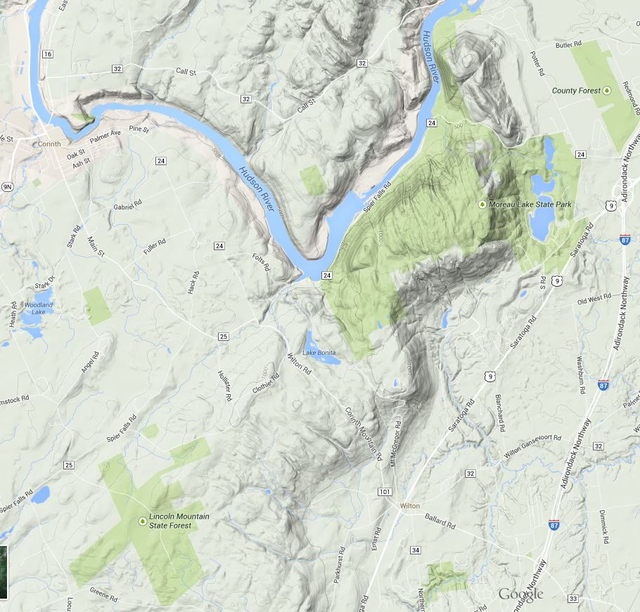
Image from Google Maps showing the location and terrain of the Park. The park includes significant areas northwest of the Hudson not represented in this map as public land (the light green shade) .
moreau_lake_trails.PNG
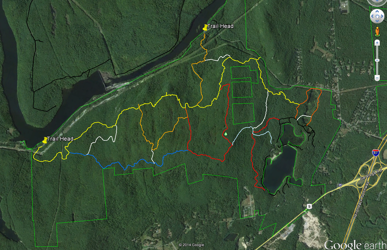
Image from Google Earth showing the trails
Some maps name this section of the ridge Grant Mountain but it would take some searching to find the summit. The ridge top area lies at an elevation of between 1000 and 1250 feet with numerous steep sided glacial cuts and small rocky ridges imparting an unexpected ruggedness to the terrain. Examination of a topographic map of the area shows that the Palmertown Range is part of the of the larger Adirondack uplift. Grant Mountain is defined by a glacial cirque and escarpment on the east side and by the gorge cut by the Hudson River on the west. You can see this clearly using the “terrain” (topographic) view in Google Maps (https://goo.gl/maps/AOaPa).

The map above (from Google Earth) shows the Moreau Lake State Park trail system with two of the west side trail-heads marked. As a point of reference, Northway (I-87) exit 17 is seen on the right side of the map. Spier Falls Road runs along the Hudson River between the two marked trail heads and a 3rd trail-head is found where the yellow trail intersects the green park boundary line in the upper right part of the image. Spier Falls Dam creates the prominent widening of Hudson in the center left of the image. The colored lines show most (but not all) of the trails in MLSP and you can download the trails file from the park website. The file is in the KML format that can be opened using Google Earth. To get some idea of the scale, from the trail-head marker on the left to the point where yellow joins orange on the right is about 4.5 miles.

There are several places along the yellow trail with good views of the Hudson River and the southeastern Adirondacks and an excellent view of Moreau Lake (and east toward Vermont) can be had at the point where the red trail joins the light blue trail. But the views are just icing for me; the ridge top area holds an intriguing and attractive landscape. The terrain is varied and it is overlaid with a matrix of past human activities and the effects of those activities. Much of the forest appears to be 100 year old (approximately) second growth but the effects of more recent logging or fire are seen in some areas. A few abandoned carriage roads can be found but I've seen no sign of pastures or structures.

The most common ecological communities of the ridge top area are the Appalachian Oak-Pine, Beech-Maple and Hemlock Northern Hardwood Forest types. At smaller scales perhaps a half-dozen additional community types present (see the notes at the end). Interesting, from an ecological perspective is that the central section is poorly drained with numerous small marshes and seasonal wet spots. These wet areas are interspersed with dry, rocky, ridges -with thin soil- where Chestnut Oaks are the dominant tree species. This combination is found around the edges of the Adirondacks uplands but it is uncommon in the interior of the range.

Over the coming weeks I'll add posts describing the natural and environmental history of this fascinating area but for now some photos will have to suffice.

Fungus seen along the trail. If anyone can ID this please leave a comment.

The Hudson just north of the Spier Falls Dam. The boat launch is located at roughly the lower left corner of the picture.

A small marsh.

Moreau Lake and the view looking east.

Looking northwest from a view point on the yellow trail.

Looking west across the southern Adirondacks; also from the yellow trail.

Spier Falls Dam on the Hudson seen from a view point on the yellow trail.

1.Ecological Communities of New York State (Edinger et al. 2014) - The definitive guide to ecological communities in New York State from the New York State Department of Environmental Conservation web site. http://www.dec.ny.gov/animals/97703.html

2. Moreau Lake State Park Master Plan Chapter Two The Moreau Lake State Park Master Plan (from the Office of Parks and Recreation) contains a detailed assessment of the the natural heritage of the park. The entire plan (comprised of several chapters) can be found on the park website.