In many parts of the U.S., Moreau Lake State Park would be a premier destination for hikers (those of us who live near the Adirondacks are totally spoiled). The park contains an extensive network of trails that pass over a varied and surprisingly rugged terrain. There are options for everything from short walks to ten mile mountain grinders. And those options just got better; much better. Two new trails have been built that integrate the 800 acres transferred to the park following the closing of the Mt. McGregor Correctional Facility and these new routes are particularly appealing.
Overview map of the new trails. from the parking area on Wilton Mountain Road it's 1.5 miles to Lake Anne. From there another mile of walking takes you to the main park trail system at junction 3.
The new routes include a well designed trail that circles Lake Bonita --a lovely and distinctive small lake that was previously inaccessible to the public-- and a connection from the new trailhead on Wilton Mountain Road to the parks' existing trail system at Lake Anne. You can find the details of what is planned in the Office of Parks, Recreation & Historic Preservation (OPRHP) addendum the Moreau Lake State Park Master Plan. I'll probably have more to say about the newly added areas in the future but, for now, a few photos will have to suffice.
Lake Bonita from one of the spur trails that provide access to the waters edge. The shoreline of Lake Bonita is mostly undisturbed and OPRHP states that the lake is free of aquatic invasives; a rarity these days. The master plan details the agency's intent to protect these attributes of the lake. Boats of any kind are prohibited and no live baits are allowed for fishing.
Lake Anne: This lovely small "bog lake" boast floating bog mats that are uncommon this far south. No fishing is allowed in Lake Anne and, given that the lake is shallow and has a measured pH of 4.3, it's doubtful that any fish could survive in its' waters.
Extensive swamps surround Lake Anne. If you like swamps as both I and biting insects do, these are wondrous places.
The connection from Lake Anne to the parks existing trail system opens the potential for long loop hikes along Palmertown ridge. The southern Adirondacks from one of the many viewpoints along the West Ridge Trail.
Looping back over the East Ridge trail you'll pass through some of the most rugged and wildest sections of the park.
Back at Lake Anne. There is a pretty decent lean-to near Lake Anne. The spot is attractive and the parks' plans call for allowing backcountry camping at this site. You would probably not want to do that in June however. Just trust me on that point.
I probably learned a lot of useful things as a boy scout in the 1960s but most of it blended in with all the other things being learned in those happy years. But the boy scouts get full credit for one bit of cultural wisdom, the boy scout motto: Be Prepared. This odd thought slipped into my active brain while I was hiking on Sunday (5/16/2016). I had pulled out my phone to see how far it was to the car on the GPS. But the phone battery was low and it had disabled the location feature to save itself. My location was no longer being recorded. And I knew there was no point in pulling the separate GPS unit out of my pack; those batteries had quit an hour before. I was carrying spare batteries but I hadn't bothered to put the new ones in.
I was plodding along, pretty much soaked thru, with the wind gusting hard enough to bend the trees and the air temperature hovering around 34 degrees. Along with the fresh batteries I had dry clothes in my pack. I just didn't want to stop to put them on. The heavy spring snow that had been falling higher up was now a steady rain and I figured that my best option was to just keep walking.
The storm at full force over Big Alderbed Vly. The video below is shot from this same spot and provides a sense of the wind that you just can't get from the still picture.
"Be Prepared" had come to mind because I had just taken a mis-step while crossing a brook; the slip left me standing in water over the tops of my boots. But even that had limited practical effect; my hiking boots had been feeling soggy for a while. Several hours of bushwhacking through wet vegetation along with rain and snow will do that.
What I did notice was that I was getting a little stumbley and not paying attention to my surroundings in the way that I normally do. I'm usually pretty careful about my footing, so slipping on a rock that was obviously slippery was an warning sign. The warning being that my body was starting to reserve warm blood for use by core organs which, under these circumstances, do not include the brain. Sort of like the phone shutting down the GPS to save a little bit of juice for one last phone call. That's when it occurred to me that I had stopped doing the things I normally do to give myself an extra margin of safety; like changing the batteries in my GPS and putting on dry clothes to stay warm. I was getting sloppy. Which is why hypothermia is so insidious. The first effect is to muddle ones thinking. But it was less than two miles back to the car and in an hour I was there. Driving home with the heater blasting I wondered if I'll see it coming the next time.
Big Alderbed Vly
My visit to Big Alderbed Vly had not gone as planned. My intent was to visit the old growth spruce stands reported to exist around Blind Mans Vly. The catch is that to get to Blind Mans Vly you have to cross East Canada Creek. Heavy rain had fallen on Friday, two days before. But water levels this spring are running below normal so I though it should be possible cross the creek. That turned out to be a bit optimistic. I looked at a couple of rock hopping options but both required making a jump from one slippery rock to another slippery rock. My old bones and (at that point) still functioning self-preservation circuits argued against that. Wading seemed possible and I put on sandals I had carried for that purpose. Unfortunately the rocks in East Canada Creek are thickly coated with algae (not sure what that's all about) and extremely slippery. As the water rose above my knees I decided that the big spruce would have to wait for another visit and turned back.
The dam on Big Alderbed Vly. The dam is broken in the center but it still constricts the flow of water and raises the water level in the pond. At times wind driven waves were pushing water over the dam remnants for much of its' length.
Plan B was to bushwhack along the south shore of Big Alderbed Vly; a one and half mile long swampy pond noted for an abundance of waterfowl. And the weather soon confirmed my choice. As I changed back into my boots the spitting snow turned to heavy wet flakes and the storm that had been threatening came in full force with strong gusty winds.
From the place where the trail crosses the creek it took only a few minutes to bushwhack to the site of the former dam on Big Alderbed Vly. At one time a rock crib dam had turned the vly into a pond. The dam was broken out long ago but it still constricts the flow of water and raises the level of the Vly. Standing there I realized that the wind --blowing straight down the narrow valley occupied by the Vly-- was pushing water up against and over the remnants of the dam. This was adding significantly to the flow in East Canada Creek. A flow that was going to be much lower after the storm passed.
Snow falling over Big Alderbed Vly. Big Alderbed Mountain in the background.
The snow did make for interesting pictures and old growth trees are seen all along the trail to the vly. In particular, there are notable ancient Yellow Birch trees as large as any I've seen. In places where spruce are mixed in there are some good sized specimens with diameters greater than 12 inches. But the really big ones I had hoped to find are on the north side of East Canada Creek. Those will have to wait for another day.
Ancient Yellow Birch. One of several very large and very old Yellow Birch seen along the trial to Big Alderbed Vly. Trees like this pre-date settlement of the region and indicate that the area was logged selectively, if at all.
For those who seek out wild places in the southern Adirondacks one name stands out. The "three ponds" located in the heart of the Silver Lake Wilderness. The ponds are located in a high basin on an otherwise nondescript mountain that bears the same name (Three Ponds Mountain). Climbing up from the "Notch" road I visited only the first of the three ponds. Bushwhacking alone, and well off the route I had said I would be on, going further seemed like pushing my luck. Not to mention that it was 2:00 PM and the climb to the lower of the three pond had been strenuous to say the least.
Starting at the Godfrey Road Parking area I followed the "old" Northville-Lake Placid Trail route to the bridge over Stony Creek North Branch. Just past the bridge the old route joins the new NLPT route. Heading south (towards Northville) it is a half mile back to the point where the long abandoned woods road through the notch forded the creek. The NLPT continues east and south and the notch route heads north following the old road (this not an official trail but for the first couple of miles it is easy to follow). At a mile from Stony Creek the road crosses a significant stream. From there it is just 1.25 miles (as the crow flies) to the lower pond. However, the climb covers 1000 feet and the upper half is characterized by dense brush. Following the stream there is a nice falls just a quarter mile from the old road. Continuing due north from there takes you up what is probably the least steep route to the ponds. I went up that way but came down following the outlet brook. The brook route is steeper but it avoids some of brush filled terrain near the top. In the image, the yellow line shows the "old" NLPT route. The dark blue line shows the route I followed. The light blue line is the approximate route of the abandoned woods road through the "notch". Image from Google Earth.
And did I mention the Black Flies? It has been an atypical spring and there was some question of whether the Black Flies have emerged for their annual rite of tormenting creatures big and small. That question is now answered. I'm sure I've seen them worse but they were pretty bad. While climbing up to the ponds I inhaled several to extract a small measure of revenge.
Three Ponds: The Lower Pond. The notch at the far end of the pond provides the route to middle and upper ponds. From where this picture was taken it's just a quarter mile to the Middle Pond and another quarter mile to the Upper Pond. But don't let the distance fool you; it's tough bushwhacking the whole way.
Basically the same shot as above, but this time with several black flies visible as dark blurs in the foreground. By this point my bug spray was not deterring them in the least.
Along with the Blackflies the spring flowers have also appeared. Painted Trillium, Red Trillium and Trout Lily were all seen (Trout Lily being very numerous).
Red Trillium: Trillium erectum - common
Painted Trillium: Trillium undulatum - Only saw these two
Trout Lily: Erythronium americanum - very common
While the ponds are not particularly scenic, the brook down from the ponds to Notch Brook is. There are a number of lovely cascades and at least one has a pool that should hold sufficient water for a cool dip even in the dog days of summer.
The outlet brook falls 1000 feet in less than a mile. Just a thin layer of top soil covers the bedrock and there are numerous attractive cascades.
The final highlight of this trip is that much of the way passes through mature second growth forest. Higher up, in places where the jagged terrain appears to have shielded (from logging) what I took to be pockets of old-growth forest. Very large Maple, Yellow Birch and Hemlock are present.
There is no inherent connection between the two hikes discussed in this post. Other than both are close to Long Lake and Elle and I walked the trails on successive days in late April 2016.
Goodman Mountain
Goodman Mountain is a small mountain near the southern end of Tupper Lake. Approaching on Route 30 from Long Lake the trailhead is on the right a half mile before you reach the intersection with Route 421. Both the mountain and the trail are named to honor Andrew Goodman. In 1964 Goodman and fellow civil rights workers James Chaney and Michael Schwerner where murdered by members of the Klu Klux Klan while working in Mississippi to register African Americans to vote. Goodman's family had a camp nearby and he was known to have climbed to the top of this mountain to enjoy the great views. The USGS renamed the mountain in 2002 and the new trail was dedicated in 2014.
The route covers just 1.6 miles and about half that distance is on what used to be a paved road (the first half mile is handicapped accessible). From the point where the trail leaves the old road to the top it is generally easy walking with just a couple moderately steep stretches. The trail passes through a very attractive and rapidly maturing second growth forest and the views from the summit are outstanding. This is as nice a short hike as you'll find anywhere in the Adirondacks and it's a great family-friendly route.
Views to the south, southeast and southwest are unobstructed and by seeking out openings in the trees you can see east towards the high peaks and into the wild country west of Tupper Lake. Prominent in the foreground is the sharply contoured summit of Coney Mountain just a couple of miles away. We owe our visit to Goodman Mountain to the extreme popularity of the Coney Mountain trail. We had intended to make the short walk (.75 miles) to the top of Coney. But arriving at the trailhead we found the parking lot full with a half dozen additional cars parked along the road. Coney is a small mountain and that seemed like a bit much. Continuing on and considering our options the sign for the Goodman Mtn. trail soon appeared. Coney has unmatched views but the trail is overused and not particularly attractive. We'll take Goodman any day.
Looking south from Goodman Mountain. Coney Mountain in the foreground and Blue mountain in the distance.
Sargent Ponds
We planned to hike the Sargent three,
lower, middle, upper.
But one we'll see another day
or we will miss our supper.
Two trails reach the Sargent Ponds from the north (access from Northpoint Road; intersection with Rte 30 in Deerland south of Long Lake Village). The two trails are connected and the trailheads are separated by just a mile and half of lightly-used rural roadway. Combining the trails with a walk along the road makes for a very pleasant loop hike of just over seven miles.
The second trail (further west) covers 2.2 miles to Lower Sargent Pond. A 1.7 mile connecting trail then takes you to a short spur trail that leads to the shore of upper Sargent Pond. From the intersection the trail returns to the road at the more eastern of the two trailheads.
Sargent Pond Loop. Map image from Google Earth.
Much of the route passes through hardwood forests with the canopy provided almost exclusively by large Yellow Birch (many reaching 30 inches diameter). This species is common in hardwood stands throughout the Adirondacks but the absence of the Birch's close friend the Maple leads me to think that this area was selectively logged. In any case, it's a generally attractive route.
Lower Sargent Pond
Fungus never sleeps. That's something you should keep in mind.
Upper Sargent Pond
Elle and one of the large Yellow Birch that dominate the forests seen along much of the route. This tree has a diameter just over 30 inches at four feet.
I'm dedicating this post to my Dad. He turned 82 yesterday. Thanks Dad for instilling my love of the Adirondacks and of hiking. Even though you'll have trouble believing this, given all the trouble you had "getting me off my duff" when I was a kid. I just want you to know that I was saving my energy for these crazy hikes. Thanks for everything. I owe it all to you.
Three separate marked trails reach the Pine Orchard east of Wells. The route from the north starts on Route 8 and leads initially to the site of a long abandoned maple sugaring operation. This is known as the Girards Sugarbush trail (Note: There are two possible starting points for this route; I'm describing the shorter one. See the notes at the end for details on the shortcut).
Route to the Pine Orchard starting at the Girards' Sugarbush trailhead on Rte 8, northeast of Wells.
This northern route to the Pine Orchard follows an abandoned woods road through the heart of the Wilcox Lake Wild Forest. The route has its' own unique appeal but it's a tough walk. The entire 5.5 mile route is marked as a snowmobile trail and for much of the way it is wet and rough. Not surprising really; in the Adirondacks snowmobile trails tend to be wetter, rockier and more in-grown than well-used hiking trails. On the plus side snowmobile trails generally have good bridges and the two major brooks you encounter along this route are crossed by solid bridges. Adding to the fun is that whomever originally picked this route somehow managed to cover the entire distance without crossing any level ground. My GPS recorded the total elevation gain for the round trip as over 3000 feet. And trust me; that's an underestimate. This is a tough route.
In mid-march I wrote that Spring had arrived in the southern Adirondacks. In mid April, following a stretch of unusually cold weather it's fair to say that Winter has made a last stand. On April 12th, ponds and swamps were frozen over and a dusting of snow remained in shaded areas. Spring is coming, but not quite yet.
So why walk this trail? For starters, the Pine Orchard never fails to impress. If not for the existence of the easy route to the orchard from Flatters road this trail would see a lot more traffic. But that route does exist; so why walk this trail? The main appeal is that this is wild county with forests that are rapidly approaching what we imprecisely refer to as 'old growth'. Some of the best stands of old growth forest in the Adirondacks are located in the the southern third of the Park and the forests you pass through along this route are representative of that.
Barbara McMartin offers an explanation for why these forests exist in her The Great Forest Of the Adirondacks. And it starts with the timing. The first settlers and loggers who headed north in the decades following the revolutionary war were naturally drawn to the more accessible areas in what is now the southern portion of the Adirondack Park. Some land was logged or cleared for farming during that first wave of settlement but the rough terrain limited the extent. On top of that, areas logged before 1850 have now had over 150 years for the second growth to reach full size and for the forests to assume characteristics that we associate with old growth. There is no definitive point at which a forest becomes "old growth" but, in the southern Adirondacks, areas mostly undisturbed for more than 150 years exhibit many old-growth characteristics. There are additional successional steps between 'old growth' and a climax forest, but forests left to their own devices for 150 to 200 years are getting there.
The second reason that old growth is found in the southeast is that the industrial loggers of the 19th century were primarily interested in softwoods; spruce and pine for pulp and lumber and hemlock for the tanning industry. Much of the southern portion of the great Adirondack forest was dominated by hardwoods: Maple, Beech, Ash and Yellow Birch with a half dozen other species mixed in.There were softwoods in the southern Adirondacks but those stands tended to be smaller and more scattered. McMartin states that while selective logging for softwoods did take place in the south the hardwoods were commonly skipped over. This helps to accounts for the mature hardwoods seen all along the route described here.
This route lies entirely in the Wilcox Lake Wild Forest. Wild Forest is a land use designation that permits some uses not allowed in Wilderness areas including limited motorized access. Still, coming upon the fireplace and outhouse pictured above was surprising and amusing. The fireplace is of the style commonly seen at DEC campgrounds, so maybe there was some easier access to this spot in the past. As it stands today these "facilities" sit idly in the middle of nowhere.
Forest scene just north of the Pine Orchard.
McMartin's hypothesis that some of the best old stands of Adirondack forest are in the south is borne out by what we see today. Mature hardwoods are seen all along this route and there is a stand just north of the Pine Orchard where the canopy trees are mostly Maples with diameters greater than 30 inches with some even larger trees mixed in. This is what an old growth hardwood forest looks like.
Notes:
There is a marked trailhead for Girards' Sugarbush on NY Route 8 two miles north of the intersection of Routes 8 and 30 (on trail signs this is referred to as 'Griffens'. From this spot the trail passes over rough terrains for over a mile to the point where it intersects the route I've described less than 100 yards from Rte. 8. To bypass this section, pass the formal trailhead (assuming you are approaching from Wells), and drive an additional 1.5 miles (approximately) and watch for an overgrown woods road on the right. It can be hard to spot but there is a sign announcing Sacandaga River Access Parking at the point where the trail enters the woods. If you reach that parking area (also on the right) you have gone to far. There is plenty of parking alongside the road right at the trailhead or you can pull into the parking area and walk back the .2 miles to the start of the trail. There is a trail register 100 yards in so you'll know for sure that you are the right spot.
Sometimes things come together in unexpected ways and you just have to savor the moment. It was four PM and I had hiked to County Line Lake from the trailhead on Pinnacle Road (southwest of Benson NY). I'd scrambled part way up the small unnamed mountain north of the lake and now I was just a mile from the trailhead at the crossing of the northeast branch of Pinnacle Creek. Pausing, I was struck by what a perfect day it was. March 26th on the calendar but not the day I had expected. Temperature in the upper 40s. A brilliant blue cloudless sky. Not an annoying insect of any kind to be seen. And the transition from winter to spring nearly complete.
Route to County Line Lake from Pinnacle Road. The side trip to the right was to the vly that is the primary source of the NE branch of Pinnacle Creek. Image from Google Maps
Ten hour earlier I had been drinking coffee and scanning a map of the southern Adirondacks looking for a place to get out for a hike. I always have a few options tucked away in the back of my mind but I was looking for someplace completely new. One of the things I love about the Adirondacks is that there are so many unique and interesting places to explore. And there it was; County Line Lake.
A small cascade on the slope of Pigeon Mountain.
As beautiful as the day was it's still March in the Adirondacks. The overnight temperature at 2500 feet had certainly dipped into the 20s. The light spray from a small cascade encased these leaves in ice.
Beaver shape the Adirondack landscape. Pinnacle creek flows through a valley where Beaver create small ponds in an endless cycle of use and reuse.
Most years on March 26th this area would still be firmly held in Winter's grasp with plenty of snow and ice. But the winter of 2015-2016 has not been most years. This winter is now in the books as one of the mildest since records have been kept here abouts. A few lonely patches of ice remain in sheltered places above 2000 feet, but very minimal. And, most remarkable of all, even the dreaded "mud season" has nearly past. In a typical winter the first couple feet of soil freezes solid. In the spring, after the snow melts, that frozen soil transitions first into a soupy mud; mud season. But not this year, for the most part this route has already dried out.
County Line Lake. March 26th, 2016. The lake sits at 2500 feet and, it was still iced over. But probably not for long. The ice was out on all the water lower down.
The namesake of this route, County Line Lake is pictured above. It's a decent sized body of water but I couldn't get a sense of the depth and it might be shallow. Bill Ingersoll notes in his Discover the Southern Adirondacks that the lake has been devoid of fish for many years. And that fits. The trail arrives at the southeast corner of the lake and basically just ends. The herd paths you typically find around a body of water that attracts fishermen and campers are not present. I crossed the inlet stream and fought through a quarter mile of brush along the north shore of the lake. From there I went up the slope of the unnamed mountain that borders the lake on the north. I wasn't looking to get to the top. I just wanted to avoid a return trip through the tangle closer to the shore. This strategy was only partly successful. The entire slope is brushy with almost no canopy sized trees.
At 2600 feet on the unnamed mountain north of County Line Lake. A snarled mess of stunted Beech saplings dominate this slope.
The forest on this slope is odd. I saw no signs of a blowdown event or fire or logging. But there are almost no large trees. The stunted trees visible in the photograph (above) are mostly American Beech and it may be that Beech Bark Disease has disrupted the normal cycle of forest succession. American Beech is a pioneer species and when the forest canopy is disturbed Beech quickly fill in. However, under some circumstances, Beech Bark Disease can kill the Beech trees before they get large enough to shade the soil so that moister loving species can get going. This can set up a cycle where Beeches fill in, die off, and fill in again. This creates a tangle of stunted Beeches that I have seen referred to as a "beech hell". Of course, that may not be what is going on at this location. The soil on this slope looked to be thin and the southwestern exposure had already left the slope bone dry. Interestingly, the few larger tree that are present (not tall but judging by the bark old) looked to be Black Cherry. Not sure what to make of that. I'd appreciate knowing the fire/logging history of this area to get a better sense of what might have led to the current state.
A beaver meadow on the inlet to County Line Lake. A short distance from the lake.
Along the inlet stream.
On my return trip I paid closer attention to the forest and it struck me that the lake is not the main attraction of this route (I might see that differently on a hot July day). The trail passes through stretches of attractive middle-aged forest with some large trees ( diameter > 30 inches) present. But it's the variety, the interesting terrain, and the streams that make this route the gem that it is.
Returning to where this tale began, sitting on the bank of Pinnacle Creek with the late afternoon light filtering through the trees, I was struck by the beauty of the spot. The first mile and a half of the route passes through a magnificent Hemlock forest; open, cool and inviting. Resting for a minute I didn't want the day to end. And hey, with three hours of daylight left why not follow the stream to it's source? Within 30 minutes I had reached the swampy vly that is the source of this brook. When the beaver have raised the water level this is probably a nice spot. But on this day the water level was low and the pond was surrounded by a mud flat. Not that it mattered. The 1/2 mile walk along the stream is as good as it gets. Through a deep hemlock forest along a brook with numerous cascades. After resting for a few minutes it was time to head for home.
Mallards on the shallow pond (vly) that is the source of the northeast tributary of Pinnacle Creek.
Hikers planning to walk the Northville Lake Placid Trail (NLTP) from south to north have long faced a bit of dilemma in deciding where to start. From the official trailhead in the village of Northville the first twelve miles of the route were along paved roads and you would have walked 14 miles, at a minimum, to reach a place where you could camp. For that reason, many thru hikers started their journey at the so called "Upper Benson" trailhead on Godfrey road.
Two new sections of trail change that calculation completely. A thru hiker might still chose to start at Godfrey road but, if you do, you'll miss two compelling new segments of the trail. The first section runs from Collins Gifford Valley Road near Northville to the Benson Road; covering a distance of 8.6 miles. The second section links the Benson Road crossing with the original route at the place where the original route crossed the West Stony Creek North Branch (the bridge about 2 miles from Godfrey Road parking area). This second section covers seven miles and both sections together add 15 miles of new trail to the the NLTP.
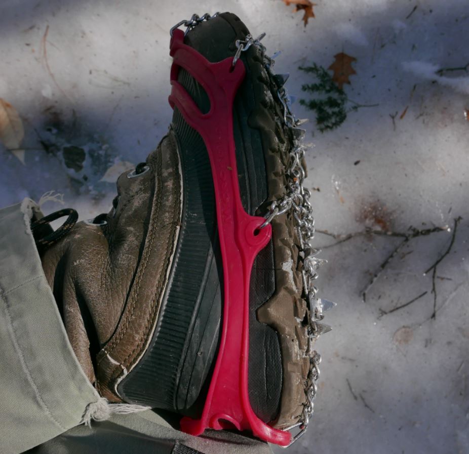
I recently walked significant portions of both of the new sections on successive weekends at the end of February and beginning of March 2016. Both trips, were made possible by the use of micro-spike "boot chains". In both cases the trails were extremely icy and neither excursion would have been possible without the micro-spikes (Images 1 and 2).
Image One
Image Two: Unusually icy conditions prevail in early spring 2016. Walking these trails would not have been practical without the use of micro-spikes.
The first of these two outings covered a portion of the the new trail that runs from the Benson Road to West Stony Creek North Branch (north of the Benson Road). The following weekend I walked the section starting at the brand new trailhead on Collins-Gifford Valley Road to the crossing of the West Stony Creek. Both hikes covered about ten miles for the round trip.
Notices at the trail registers warn that though a bridge is planned, currently there is no bridge over West Stony Creek. This is important for anyone planning to start a NLTP journey at the Gifford Valley trailhead because West Stony Creek is a significant stream. The creek can easily be forded at times of low water, but in the spring, or after heavy rains, it could present an impassable barrier.
Image Three: The only other hiker I saw on two full days of hiking is seen above on the far side of Stony Creek. He evidently hiked from the Benson road south to the creek crossing.
Not surprisingly, on the day I was there, March 6, 2016, fording the stream would have been a risky undertaking. West Stony Creek at the place where the trail crosses is wide and in early spring it carries a significant volume of water. The creek does look to be shallow, probably no more than knee deep, but with lots of ice and freezing water to contend with I can't imagine a casual hiker trying to cross at this time of year. The crossing will look completely different in six weeks and by mid-summer it might be possible cross without getting your feet wet. But without a bridge you need to factor the creek into any plan to pass thru this section. I shot a couple of short videos to illustrate.
I'm going to come back to these two outings in future posts, but for now I'll let a quick summary and some photos do the talking. Setting aside the value that these re-routes provide by finishing the long story of the NLTP, the first section, from the Collins Gifford Valley Road to the West Stony Creek crossing is a great new hiking route all on its' own. After climbing steadily for the first mile this section of trail enters a rapidly maturing oak forest that is notably different from forests along most of the NLTP. Then, at just under two miles you reach Mud Pond. The setting for the pond is attractive and open rock is visible on the ridge line northeast of the pond. The ridge appears to be easy to reach and probably has some nice views. I'm planning to return at some point to see for myself.
Image Four: Mud Pond in late winter splendor.
Past the pond the trail passes through a complex of small ridges coming down from the surrounding mountains and it crosses two stream carved valleys. Along the way the forest transitions to a more typical mix of Hemlock and northern hardwoods. This is a very attractive section of trail and the second major stream crossing, about a mile from Stony Creek, is at the head of a small gorge that also looks to be well worth a visit with time to explore.
Image Five: Details seen along the trail.
At just under five miles the trail reaches the ford of West Stony Creek. The area of the crossing, on the south side of the creek, looks to have a number of attractive potential camping spots and I suspect that this will become a well used destination.
All in all, the five mile stretch south of Stony Creek is a lovely hike on its' own terms and I have no doubt that I will return soon. When it is possible to cross it's 2.8 miles from the north bank of the creek to the Benson Road. Walking that section of trail is near the top of my list of possible future outings.
The second of my two recent hikes started at the Benson Road and covered the first five miles of the seven mile route to where the new trail joins the prior route of the NLTP. That outing was similar to the one I've just described with very ice trail conditions defining the day. The highlights of this section include the passage of Woods Lake; a long-time favorite local destination. Along the mile long shore of the lake the trail traverses some splendidly rugged terrain in crossing a ridge of Little Cat Head mountain. Little Cat Head reaches barely 2000 feet in elevation but it's an intriguing mountain with potential viewpoints. From the ridge to the point where I turned around the trail passes through mostly young second growth forests with sections of more mature Hemlocks along a couple of small ridges. I suspect that the section from where I turned back to the place where the new trail joins the old route is more interesting, but I had to leave that for another day. The Ten mile round trip --crunching along over icy ground the whole way-- is my limit for this time of year.
Image Six: Glare ice along the shore of Woods Lake. Heavy rains in the prior week followed by a temperature plunge to near zero created hard ice conditions.
This is a follow up to my previous post on GPS accuracy. Basically, I returned to the same location --the wading pool in the Roosevelt Baths Quad at Saratoga Spa State Park-- and recorded additional sets of GPS fixes using the Garmin GPSMap 64s and the Garmin eTrex. Image One is a screen capture from Google Earth showing the results. The green markers represent the fixes recorded using the 64s and the red markers were recorded using the eTrex. The red dots represent the actual locations.
Image One: Screen capture from Google Earth. The green markers represent locations recorded by the Garmin GPSMap 64s and the red markers are from the Garmin eTrex Venture HC. The red dots show the points where I stood to record the locations.
My intent, as described in detail in the previous post, is to understand the level of accuracy that can be obtained using inexpensive (less than $300) GPS devices and to determine the factors that affect that accuracy. From that perspective, the average accuracy of the fixes recorded on this visit to the Spa State Park site are similar to those obtained on the previous visit. Slightly better overall, but not substantially different.
The majority of the fixes recorded by both units where within ten feet of the actual and both recorded some fixes within five feet of the actual. Using the criteria discussed in the previous post these are excellent results. My methodology is to record a fix with each unit, walk to the next location and repeat the process. Starting at the upper left I proceeded to the lower left, lower right, and upper right corners of the pool. The green marker labeled 001 was the first fix recorded using the 64s and the red marker labeled 001 was obtained a few seconds later using the eTrex. I made three circuits so there are three markers for each unit at each corner.
On the third circuit I used the location averaging feature available on both devices. When using averaging the GPS device grabs a sequence of fixes at the location and averages those fixes to produce a single fix that should be more accurate. I have not seen a description of the algorithm these devices use to do the averaging, but an educated guess is that the units temporarily store fixes obtained using different sub-sets of the full set of satellites from which the unit is receiving signals. Comparing these trial fixes would allow the unit to drop signals that don't fit well with the others. See the previous post for a discussion of conditions that can reduce GPS accuracy.
To make it easier to see how these results compare I grabbed an additional screen capture showing a closer view of the lower left corner of the pool (the second stop on the circuit). And this brings me right back to the title of the first post; GPS accuracy is not a simple matter. As you can see, the distance from the Green marker 010 to the actual is 1.3 feet as measured using the Google Earth measurement tool. That fix, obtained on the 3rd circuit of the pool using the averaging feature of the 64s, was the most accurate fix obtained by either unit. But the 64s also recorded one of the worst fixes of the day at that same location. The green 002 marker, recorded by the 64s on the first circuit of the pool, is 16 feet away from the actual. That's not terrible but it is the 2nd worst result for either device on any of the three circuits. Given that the second time around the 64s recorded a fix about five feet away from the actual (green 006) it was probably the case that the 002 marker incorporated a signal from a satellite with corrections pending, and that that through off the result.
In summary, the accuracy you obtain using inexpensive GPS devices will almost always be better than the 30 foot level that the manufacturers claim for these devices. And it can be much much better with best case results under five feet. But that level of accuracy requires an understanding of how these devices work and what factors reduce accuracy. To obtain these 'best case' results you should turn your device on several minutes before recording the first fix -this allows your GPS device to download the satellite correction data it needs to make proper use of each satellite. Secondly, use the averaging feature of your GPS if it has one. Or, take several readings at the same location a few seconds apart and do the averaging yourself.
Most important, be skeptical. It may be that the one foot accuracy I got on this go round is a fluke. After all, I didn't see that on my first visit to the same site. Leaving me to wonder, what will the next visit show?
Image Two: Screen capture from Google Earth. The 1.3 feet distance from the actual location to the green marker 010 (third circuit) was most accurate fix by either unit. Confouding that, the green 002 marker, also recorded by the 64s, was one of the worst.